RCAF Stations in New Brunswick:
Moncton, Pennfield Ridge, Saint John and St. Margarets
RCAF Station Moncton
RCAF Station Moncton, also known as RCAF Aerodrome Moncton and BCATP Station Moncton, New Brunswick was a Second World War training air station of the British Commonwealth Air Training Plan (BCATP). The Moncton aerodrome was the home of No. 8 Service Flying Training School, RCAF, which operated from 23 December 1940 until the school was relocated to RCAF Station Weyburn, Saskatchewan on 24 January 1944.
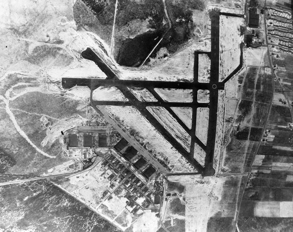
(Library and Archives Canada Photo, MIKAN No. 3583747)
RCAF Station Moncton, overhead view of the airfield, 25 Apr 1945.
The primary relief landing field for RCAF Station Moncton was located west of the community of Scoudouc, NB and the secondary relief landing field was located northwest of the community of Salisbury, NB. After the end of the Second World War, the property was converted into a civilian airport and is now operated as the Greater Moncton Roméo LeBlanc International Airport.
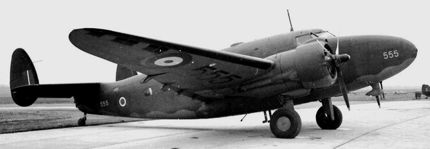
(Library and Archives Canada Photo, MIKAN No. 3643719)
Lockheed Lodestar, RCAF (Serial No. 554), 23 Nov 1943.
Shortly after the beginning of the Second World War, Prime Minister McKenzie King promoted the establishment of the British Commonwealth Air Training Plan (BCATP), with aim of training airmen from the Commonwealth throughout Canada, away from the threat of hostilities in Europe. A total of 131,553 pilots, navigators, bomb aimers, wireless operators, air gunners and flight engineers were trained under this program. In 2003 the Canadian Society for Civil Engineering erected a plaque in the McClure Aviation Museum at the Moncton International Airport recognizing the Moncton No. 8 Service Flying Training School, RCAF, as a National Historic Civil Engineering Site. (NBMHP)
RCAF Station Moncton was an operational station with No. 164 (Transport) Squadron stationed there from 20 January 1943 to 30 September 1945. No 8 Service Flying Training School, part of No 3 Training Command of the British Commonwealth Air Training Plan was established in Moncton for pilot training in December 1940, 16 weeks a head of schedule, although handicapped by a shortage of aircraft.
After completing their initial training course, those selected for pilot training went to Moncton for a seven week elementary flying training course. The failure rate in this phase was about 25%. In January 1944 it was moved to Weyburn, Saskatchewan. No. 31 Personnel Depot was also located at Moncton, a reception centre for members of the RAF moving to and from Canada and the United States. No. 2 Embarkation Depot was also located in Moncton.
RCAF Station Pennfield Ridge
The British Commonwealth Air Training Plan developed a total of 151 training schools across Canada and RCAF Station Pennfield was one of three built in New Brunswick. Pennfield Ridge grew from a community of 188 people in 1939 to approximately 5,000 in 1942, complete with hospital, theatre, dance hall, sport facilities, and restaurants.
In November 1940, a half million dollar contract was awarded to build a facility at Pennfield Ridge. From mid 1941 to May 1942 the station was home to No. 2 Air Navigation School. This school conducted a four week intensive course on astro navigation, designed to qualify students for night navigation.
From Pennfield Ridge this school was relocated to Rivers, Manitoba. After the fall of France, it was decided to move four operational training units (OTUs) from Great Britain to Canada. Once airmen had successfully learned their trade, they were sent to an OTU for operational training on a particular aircraft and for a particular task. No. 34 Operational Training Unit was sent from Greenoch, Scotland to RCAF Station Pennfield Ridge in April 1942. This station was part of No. 3 Training Command of the British Commonwealth Air Training Plan and both the RCAF and RAF shared the responsibility for running the base and school.
RCAF Station Pennfield Ridge was an RCAF training station located in coastal Charlotte County in the hamlet of Pennfield Ridge. Construction of the aerodrome began in the summer of 1940 after a suitable site was selected on a ridge high above the surrounding coastal plain of the north shore of the Bay of Fundy, east of the town of St. George. Proximity to a Canadian Pacific Railway line running between St. Stephen and Saint John eased the transport of building materials. General contractor Dexter Construction had 200 workers on the project by August 1940 and the runways were finished by November. The base was located southwest of Camp Utopia, an army training facility for southwestern New Brunswick. (NBMHP)
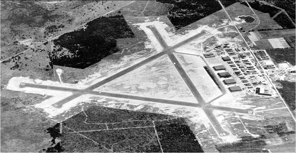
(Library and Archives Canada Photo, PA177628)
RCAF Station Pennfield Ridge, ca 1945.
By the end of summer 1941, over 40 buildings had been constructed on the base, including 4 large hangars, an observation tower, barracks, drill hall, mess halls and classrooms, along with a water supply and internal telephone system. The three runways were lengthened in the fall of 1941 into the classic BCATP triangle arrangement.
The first test flights took place on 1 January 1941 and the base officially opened on 21 July of that year, housing No. 2 Air Navigation School, RCAF.
The Royal Air Force (RAF) operated No. 34 Operational Training Unit (OTU) on site from 1 June 1942 until 19 May 1944. No. 34 OUT also operated No. 34 OTU Detachment, Yarmouth, Nova Scotia from 20 August 1942 until 30 April 1943. Two detached flights, No. 126 (F) Squadron and No. 127 (F) Squadron, operated at different times at the station, providing fight affiliation for those in training at No. 34 OTU. (NBMHP)
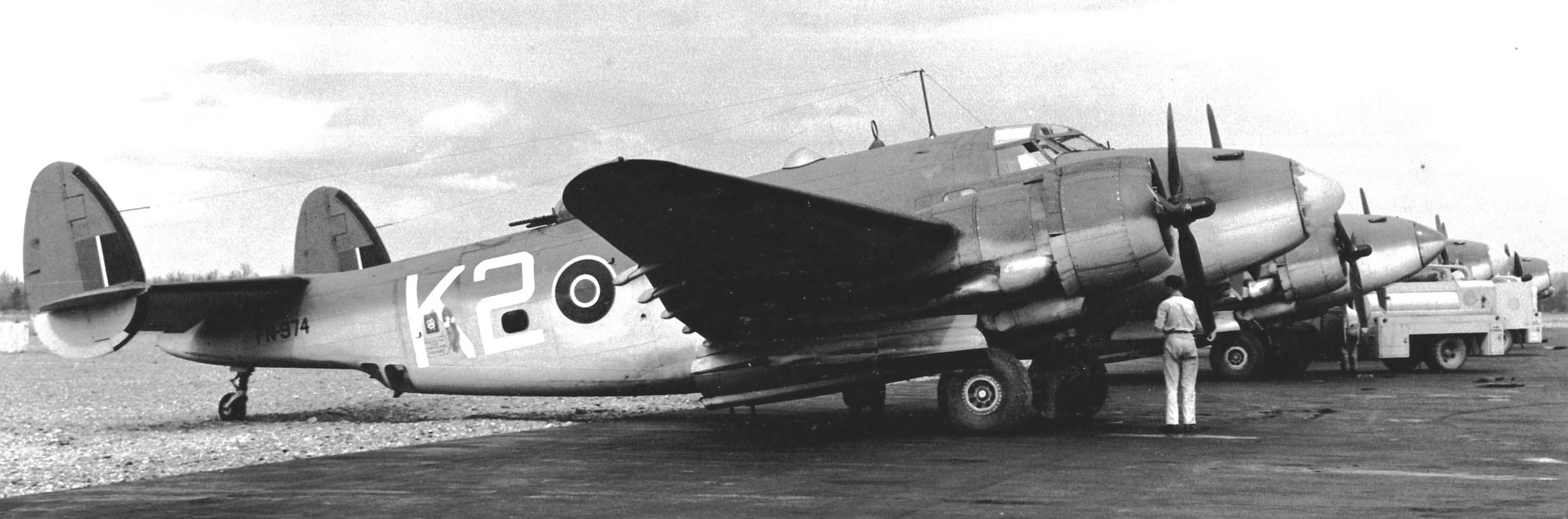
(Library and Archives Canada Photo, MIKAN No. 3650941)
Lockheed Ventura GR Mk. V, RCAF (Serial No. 2183), coded D, Jan 1944.
RCAF Station Pennfield Ridge had Lockheed Venturas, a light bomber, for the training of four man-crews for Bomber Command. The course for pilots and wireless operators was 12 weeks long and for air observers it was 8 weeks. Each group trained separately at first and in the final stage trained as a crew. It was operational from May 1942 to June 1944. Occasional operational missions were flown from this airfield into the Atlantic Ocean. The station experienced a number of difficulties due to serviceability problems with Venturas, persistent fog, and a lack of operationally trained instructors. (NBMHP)
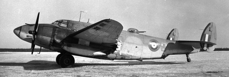
(RCAF Photo)
Lockheed Ventura GR Mk. V, RCAF (Serial No. FN974).
After the departure of No. 34 OTU, it was taken over by the RCAF on 20 May 1944 under the command of W/C W.W.S. Ross. No. 34 OTU was part of No. 3 Training Command, RCAF, which was headquartered in Montreal, Quebec, as part of the British Commonwealth Air Training Plan (BCATP). At that time, the Station was comprised of an Operational Training Squadron (OTS) with F/L Van Elslande as its Squadron Commander, and a Transport Conversion Squadron (TCS) with F/L L.B. Stevenson as its Unit Commander. Eastern Air Command School of Survival, a smaller training unit, was organized at the station in May of 1945 under the command of F/L G. Durrell. This school gave an extensive course in survival measures for those heading to the far East.
The airfield was decommissioned by the RCAF toward the end of the Second World War, with air force activities in eastern Canada being concentrated at RCAF Station Greenwood, Nova Scotia, RCAF Station Debert, Nova Scotia, RCAF Station Summerside, Prince Edward Island, and RCAF Station Chatham, New Brunswick. The Pennfield Ridge base became the operational location for a Heavy Transport until it was purchased several years later and operated by a commercial airline company as an alternative to the inadequate airport serving Saint John at Millidgeville.
Pennfield Ridge was operated as a Trans Canada Airlines (TCA) airfield from 1947 until 1951. The inaugural TCA flight took place on 15 April 1947 with co-captain of the flight being Peter Hamilton, a former trainee at No. 34 OTU.
After the new Saint John Airport was opened in the early 1950s, Pennfield Ridge closed as an operational airfield. One of its runways was used as a drag racing track by the New Brunswick Drag Racing Association during the 1950 up to 1996. Today, 2 of the 3 runways are used for drying seaweed which is then marketed as a natural plant fertilizer. The remaining runway is still able to handle small aircraft under visual flight rules (VFR) conditions; there is a small fuel reserve tank for the use of J.D. Irving Ltd, and New Brunswick Department of Natural Resources aircraft.
Less than 2 km (1.2 mi) to the east of the airfield is the location of the Jim Mollison landing in August 1932, in which Mollison completed the first solo east-to-west transatlantic flight. His aircraft was a de Havilland Puss Moth (G-ABXY) dubbed “The Heart’s Content“.
On 24 September 2006, a memorial was erected at a nearby park in Pennfield by “The Charlotte County War Memorial Committee” to honour the sixty men that died while on training at Pennfield Ridge.
Subsequent research by Pennfield Parish Military Historical Society shows that seventy men died while training at Pennfield Ridge. There were six civilian casualties as well. (NBMHP and G Christian Larsen)
RCAF Station Saint John
RCAF Station Saint John or RCAF Aerodrome Saint John, was a military aerodrome that was established at the St John Municipal Airport in 1939. The airport was in the neighbourhood of Millidgeville. In 1939 the RCAF took over operation of the Saint John Municipal Airport. The air force constructed additional hangars and other buildings at the site. From 1939 until 1940 a flight from No. 2 (Army Cooperation) Squadron was stationed at RCAF Station Saint. John. They were replaced by No. 118 (Coastal Artillery Co-operation) Squadron who remained at the station until April 1944 when they were transferred to RCAF Station Dartmouth, NS.
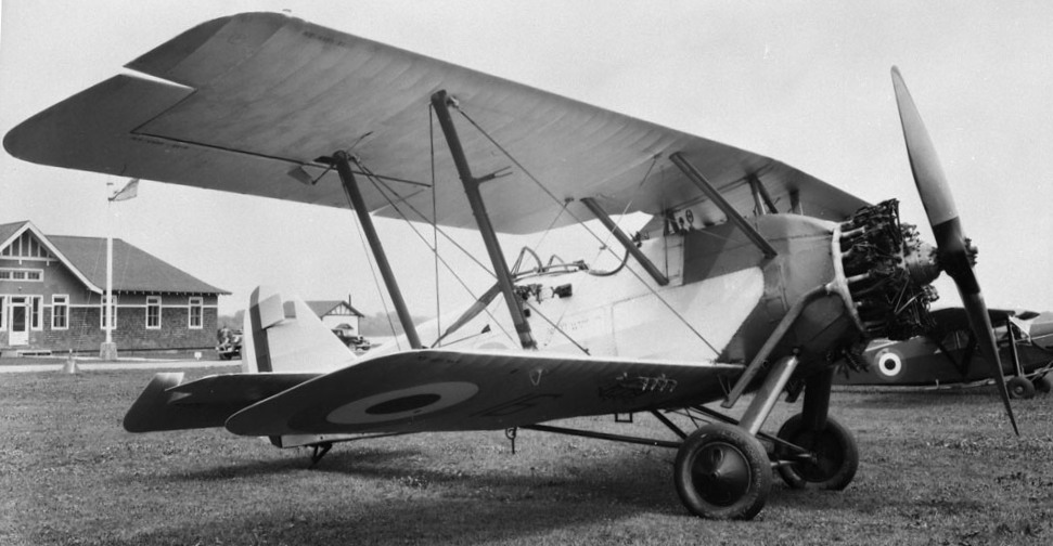
(Library and Archives Canada Photo, MIKAN No. 3521019)
Armstrong Whitworth Atlas Mk. I, RCAF (Serial No. 16), Rockcliffe, Ontario, 12 July 1934.
By the fall of 1941, the Saint John airfield was one of six operational fields in Eastern Air Command of the RCAF. Stationed at the municipal airport at Millidgeville there from 1 November 1939 to 27 September 1940 was a flight of 2 (Army Cooperation) Squadron, flying four Armstrong-Whitworth Atlas aircraft. These were soon after replaced by modern Westland Lysanders
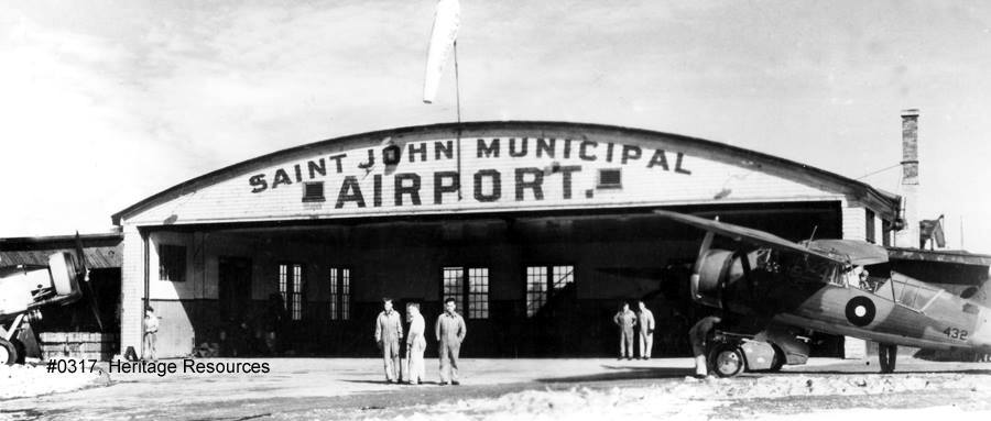
(Heritage Resources photo via Harold Wright)
The RCAF constructed one hangar which is still onsite. No. 117 Sqn. was the first unit at the Station in August 1939. Civilian flight operations at the airport continued until December 1951 Westland Lysander and a Blackburn Shark are shown here in front of the Municipal Hangar.
(Author Photo)
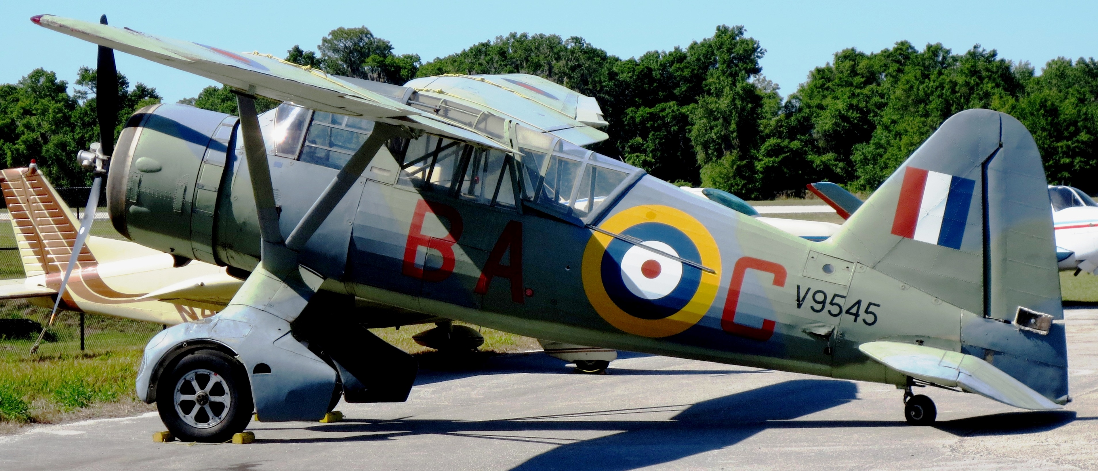
Westland Lysander (Serial No. ), Sun n Fun Florida Air Museum, Lakeland, Florida.
In the fall of 1939 a hanger and other buildings were built for the RCAF detachment at Millidgeville. No 2 Squadron was replaced by 118 (Coastal Artillery Co-operation) Squadron from 1 November 1939 to 27 September 1940. No. 118 Squadron was renumbered No. 1 (Coast Artillery Co-operation) Detachment and it remained until 1 April 1944. By the end of January 1944 1 (CAC) had been made redundant by army radar equipment, it was first transferred to Dartmouth, Nova Scotia, and then disbanded.
Shortly after RCAF Station Saint John was closed as part of the East Coast Air Defence Radar Coverage, No. 23 Radio Unit (Ground Control Intercept radar) was located at Saint John.
The majority of RCAF Station Saint John closed in early 1944. A six-member Detachment remained at the station until the Airport was turned back to the city of Saint John in May 1947 and the city operated the municipal airport at the site until Decemnber 1951 when the aerodrome was de-commissioned and flying operations were relocated to the new Saint John Airport. The former Municipal Airport and RCAF Station occupied an area that is bounded by the modern-day roads: Millidge Avenue, Daniel Avenue, Marlin Drive, Woodward Avenue and Boars Head Road. The main Runway followed the came course and distance as modern-day Donaldson Street. (NBMHP)
RCAF Station St. Margarets, (after 1968, Canadian Forces Station St. Margarets), New Brunswick.

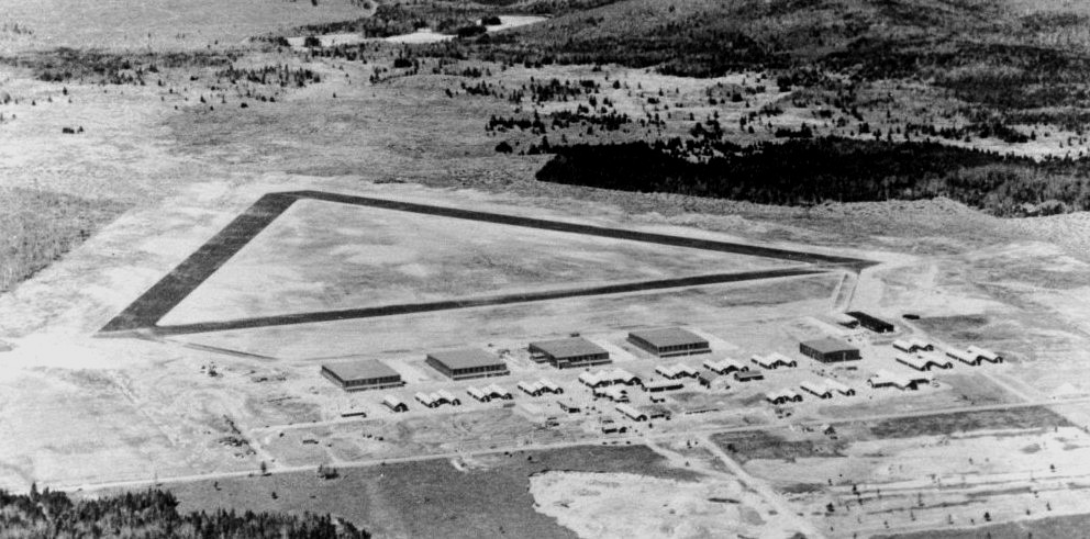
(Paul Richard Photo)
Aerial Photo of Canadian Forces Station St. Margarets, 1976.
It was operational as a Pinetree Line radar station from November 1953 to April 1988 and as a satellite tracking station from 1975 until its closure in 1989. It was involved in Operation Skyshield II in October 1961 which involved tracking “Enemy and Friendly aircraft engaged in a North American wide mock air battle. Personnel from this station and others involved were restricted to base until 16 October 1961 resulting in some personnel postponing personal plans such as weddings.
Today the facility has been renamed to James Park in honour of Air Vice-Marshal Arthur Lorne James. James Park is operated by a local development authority which has sold or rented many of the residential units. Most of the military buildings have been demolished since the facility was decommissioned in 1989.
The RCAF selected the community of St. Margarets for the location of a radar station in the early 1950s to close a key gap in air defence coverage. RCAF Station St. Margarets was constructed on what was then called the Old Yellow Road, today Highway 11, approximately 5 km (3.1 mi) northwest of the county line between Northumberland County and Kent County and approximately 20 km (12 mi) southeast of the air base at RCAF Station Chatham. Construction began in 1951 under general contractor Diamond Construction and it went operational on 1 November 1953, as part of the Pinetree network of radar stations when the ground control intercept operation was moved from RCAF Station Chatham.
During the 1950s and 1960s, RCAF Station St. Margarets was staffed by approximately 300 RCAF personnel and supported by approximately 100 civilians. Its location was designed to provide coverage of a large portion of the western Gulf of St. Lawrence as well as northeastern Maine, New Brunswick and Prince Edward Island to complement RCAF operated Pinetree Line stations at RCAF Station Moisie, PQ to the north, RCAF Station St. Sylvestre, PQ, to the west, RCAF Station Beaverbank, NS, and RCAF Station Barrington, NS, to the south, and RCAF Sydney, NS, to the east. The USAF also operated four Pinetree Line stations further east at Stephenville, St. Anthony, Gander and St. John’s, Newfoundland.
Radio callsigns used by the St. Margarets radar station throughout its operation from 1953-1988 included “MOHAWK”, “BROMIDE”, “CHOPSTICK”, “MIDWIFE” and “BILLYBOY”.
The St. Margarets station consisted of several radomes housing the early warning and ground control intercept radars, as well as supporting buildings including residences for personnel and a school. The primary lodger unit established at the station was No. 21 Aircraft Warning Squadron; this unit formed at RCAF Station Chatham on 21 November 1952, while the station was under construction and moved to St. Margarets on 15 October 1953. The station was operationally controlled by Sector Commander 2 ADCC, RCAF Station Chatham and was part of the Fredericton Sector of the Pinetree Line.
In August 1957 a new school was opened by the RCAF for children of personnel. It was named James Park School in honour of recently retired Air Vice Marshal Arthur Lorne James. The Post Office Department had established a post office at RCAF Station St. Margarets in 1954 named “Post Office RCAF St. Margarets.” The name of this post office was changed in 1966 to “Post Office James Park” following the death of Air Vice-Marshal Arthur Lorne James in 1964.
Search radars installed at the facility included models AMES-11, FPS-3, FPS-502, and FPS-508. No. 21 Aircraft and Warning Squadron was renamed to No. 21 Radar Squadron on May 8, 1958. That year saw the implementation of a partnership between the USAF and RCAF to form the North American Aerospace Defence Command (NORAD); consequently, many Pinetree Line radar stations were upgraded for automation and consolidation of intercept data. RCAF Station St. Margaret’s radar equipment underwent an upgrade in the late 1950s and early 1960s with the operational implementation of the Semi-Automatic Ground Environment (SAGE) System on 1 November 1963. Under SAGE, the St. Margarets station collected, discriminated and transmitted its radar coverage data to the designated SAGE Control Centre in the Bangor NORAD sector at Topsham AFS, Maine.
The Semi-Automatic Ground Environment (SAGE) was a system of large computers and associated networking equipment that coordinated data from many radar sites and processed it to produce a single unified image of the airspace over a wide area. SAGE directed and controlled the NORAD response to a Soviet air attack, operating in this role from the late 1950s into the 1980s.
Air bases at RCAF Station Chatham and Loring AFB in Maine were the nearest bases for interceptor aircraft that would respond to anything detected by the St. Margarets main radar. The SAGE upgrade in 1963 also saw RCAF Station St. Margarets become the designated Back Up Intercept Control One (BUIC I) for the Bangor NORAD sector. This evolved to become a BUIC II site in 1966 which lasted until the end of 1968.
On 1 February 1968, the RCAF merged with the RCN and the Canadian Army to form the Canadian Armed Forces. As part of the unification, many isolated radar stations comprising the Pinetree Line, the Mid-Canada Line and the DEW Line were renamed to become separate Canadian Forces Stations (CFS). In the case of RCAF Station St. Margarets, however, the facility’s proximity to the air base at RCAF Station Chatham saw this radar station realigned to become a detachment of the base. The air base was renamed CFB Chatham, thus the radar station was renamed to CFB Chatham, St. Margarets Detachment.
Under the BUIC III program, the St. Margarets facility was assigned to become a BUIC NORAD Control Centre (BNCC) in 1969. This saw No. 21 Radar Squadron renamed to No. 2 BNCC Squadron. By 1972, BUIC was winding down and St. Margarets became the only BNCC within the 22nd NORAD Region.
In 1974 the St. Margarets facility was selected as the site for a Satellite Tracking Unit (SITU) as part of Air Defence Command – reorganized into Air Command that year. The SITU formed on July 7, 1975, at St. Margarets and supported NORAD’s space defence role to collect, analyze and transmit satellite tracking data to the NORAD Space Object Identification Centre (SOIC) at NORAD headquarters in the Cheyenne Mountain Operations Center (CMOC) at the Cheyenne Mountain Complex, Colorado. The SITU used a Baker Nunn satellite tracking camera system, and this was augmented in 1978 by the Space Object Identification Telescope.
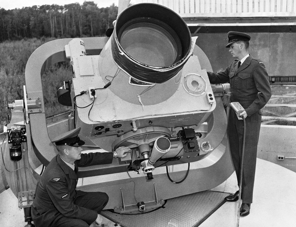
Baker Nunn Camera, Cold Lake, 1965. (Library and Archives Canada Photo, MIKAN No. 4118611)
Through the early 1980s the St. Margarets facility functioned as the controlling site of the 22nd NORAD Region until the consolidated Regional Operational Control Centre (ROCC) for the realigned Canadian NORAD Region at CFB North Bay in August 1984. At that time St. Margarets reverted to being a long-range radar site (in addition to the SITU as its BUIC function was phased out.
In 1985 the DND announced that the Pinetree Line network of radar stations would be closed. The final day of operations for the radar equipment at St. Margarets was 1 April 1988. The SITU was relocated from the facility in 1989 and the property was decommissioned and declared surplus.
All comments are subject to our Comment Policy. You must be at least 18 years old to comment.
See a comment that violates our guidelines? Report it here.