Bedolina Map, stone carving in Italy
The Bedolina Map

The Bedolina Map (formally Rock 1 of Bedolina) is a famous engraved prehistoric rock which is part of the Camonica Valley (Alps, Italian side, Lombardy region) petroglyph complex. It is known as one of the most ancient topographic maps,[1] interpreted as a depiction of cultivated plots, mountain paths and villages. The locality of Bedolina pertains to the Capo di Ponte municipality (BS-I), near the hamlet of Pescarzo. The area is included in the Seradina-Bedolina Archaeologic park, lying on a prominent terrace on the right slope of the Camonica valley, at an altitude of 530 m above the sea level. The rock, a flat surface of Permian sandstone (Verrucano of Lombardy) polished by the Pleistocene glacier, is 9 m long and 4 m wide.
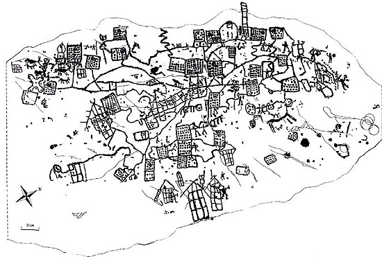
The general archaeo-iconographic tracing of the Bedolina Map (1996)
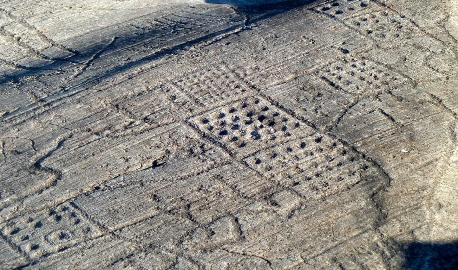
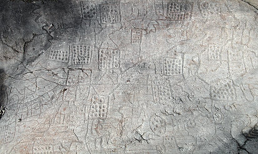
A total number of 109 figures were carved during the late Bronze Age and the Iron Age (1000-200 BC), mainly the so-called topographic patterns[3] (dotted squares and zigzagging "paths"), warriors, animals, wooden huts, cup-marks and a Camunnian Rose. The rock has been completely recorded and studied by Miguel Beltrán Llorís (Beltrán Llorís 1972) and more recently by Cristina Turconi, for the Milan University. According to the most recent studies and to the close examination of figures and superimpositions, the best known engraved patterns of the Bedolina Map, precisely "maps", likely pertain to the Iron Age, and more in detail to the central centuries of the 1st millennium BC (6th-4th centuries BC). (Wikipedia)
The Bedolina Map is a set of petroglyphs engraved on a sandstone slab of about 35 m², located at an altitude of 530 meters , overlooking the Valcamonica valley. This site belongs to a larger ensemble of rock art that includes about 200,000 engravings, an exceptional testimony to the evolution of prehistoric societies. Dated to the end of the Bronze Age (around 2200 to 750 BC), then enriched in the Iron Age, this map was engraved by the Camunni, a protohistoric population that occupied this Alpine region. It represents an early attempt at modeling the territory, probably for the purposes of social and agricultural organization.
Archaeologists have identified four phases of engraving in the creation of this map:
Phase A : Representation of human and animal figures. Phase B : Drawing of the topographic plan in its entirety. Phase C : Adding houses, animals and armed warriors. Phase D : Added five stylized characters. This superposition of engravings bears witness to an evolution in the lifestyle of the inhabitants of the valley and the increasing complexity of their society. Unlike the abstract petroglyphs found elsewhere, the Bedolina map exhibits a high degree of structure and precision, making it a true topographical map engraved in rock, the first antique map of Italy.
The main elements represented are: Plots of fields, suggesting organized agriculture. Houses and farms, with stylized sloping roofs.Roads and paths, connecting different spaces. Watercourses and irrigation systems, evidence of sophisticated water management. Human and animal figures, illustrating the coexistence between man and his environment.
This map is not only intended to demarcate a territory , but also seems to respond to practical, social and religious needs. Indeed, archaeologists believe that many elements of the Bedolina map are in some way prayers to the gods, in particular to ensure good harvests. The spatial organization observed on this slab proves that cartography was not just a Greek or Roman tool, but a more ancient form of knowledge, used since prehistory to structure human societies.
The Bedolina map reflects a fundamental turning point in human history: the transition from a way of life based on hunting and gathering to a sedentary society, centered on livestock breeding and agriculture. By mapping their living space, the populations of the time sought to organize their territory and perpetuate a collective memory. This act marks the emergence of new concerns:
- Land ownership, with a desire to demarcate cultivated land.
- Agricultural planning, essential for resource management.
- Social hierarchy, with distinctions between residential areas and agricultural spaces.
- Warlike conflicts and incursions, involving a more organized defense of the territory.
Thus, this rock map is much more than a simple engraving: it embodies the beginning of the structuring of human societies, laying the foundations of future civilizations. With its detailed engravings and complexity, the Bedolina Map is one of the oldest surviving examples of cartography in the world. It illustrates how early civilizations structured and represented their environment, long before modern maps. It reminds us that cartography is a fundamental tool for understanding, organizing and transmitting knowledge about our world, a principle that remains at the heart of our contemporary societies. (Votre Carte Ancienne)
(Pablo Allard)
Bedolina Map stone.
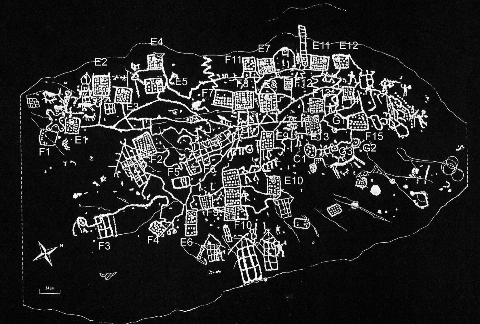
Turconi's tracing of the Bedolina map.
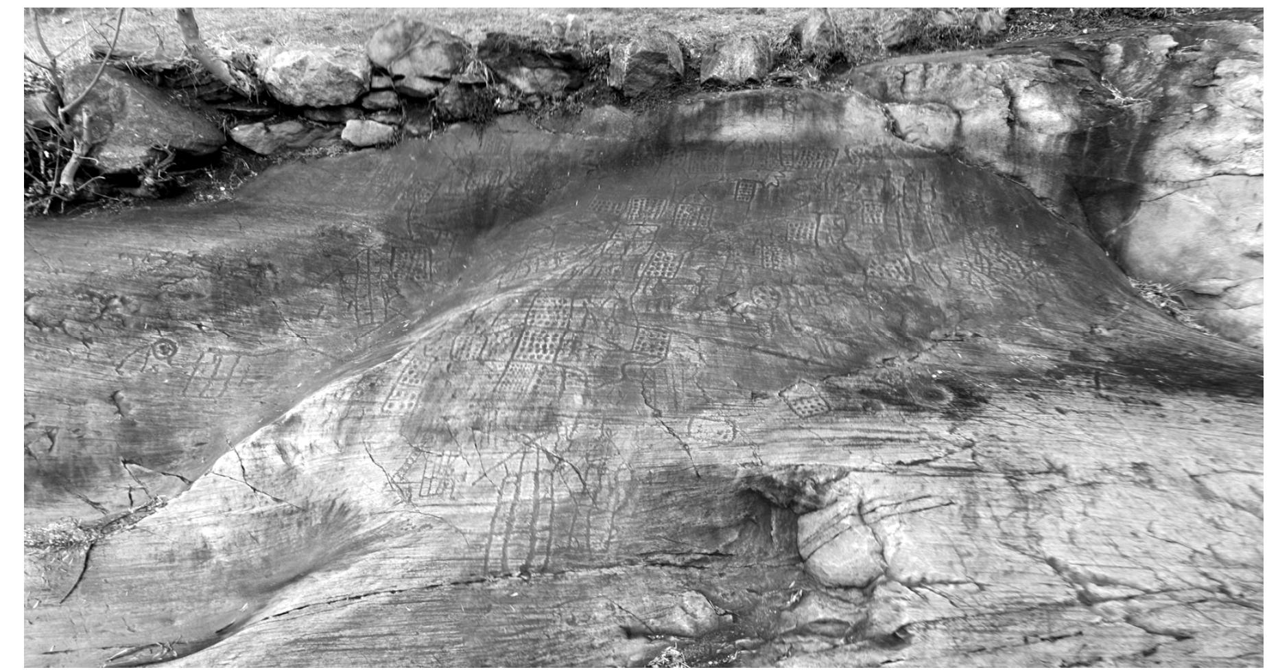
The Bedolina Map mappiform at Bedolina is situated in a commanding position on the western slope above the valley floor just outside Capo di Ponte in the mid-section of Valcamonica. It is probably the most complex example known in the valley. The rock itself measures about 9m x 4.3m while the engraved area measures about 4.3m x 2.4m. There are 6 readily identifiable buildings and around 30 fields — that is, geometric forms typically identified as fields. (Academia)
