Standing Stones, Menhirs, Dolmens, and Ancient Stone Circles
(Angela Findlay Photo)
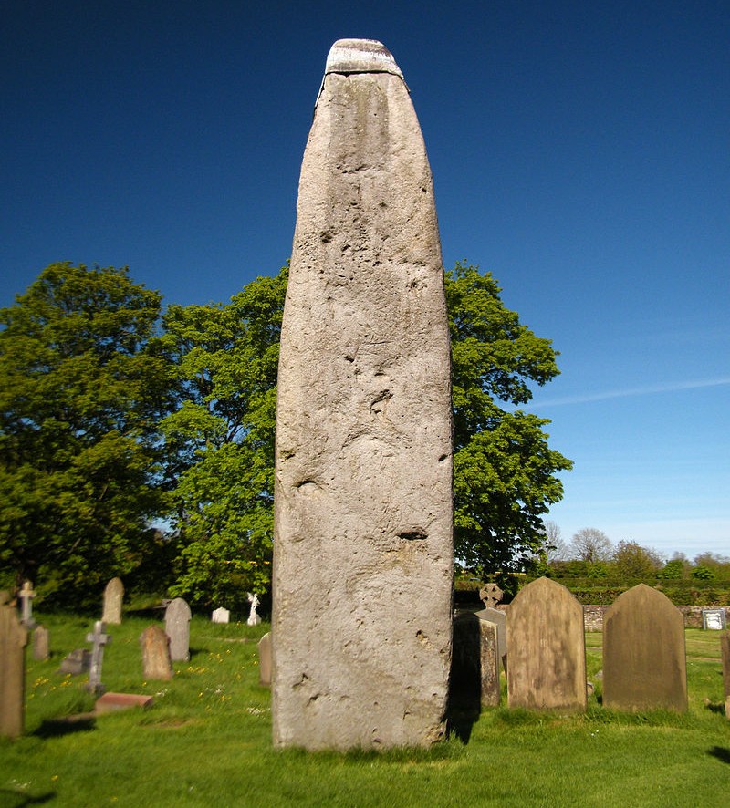
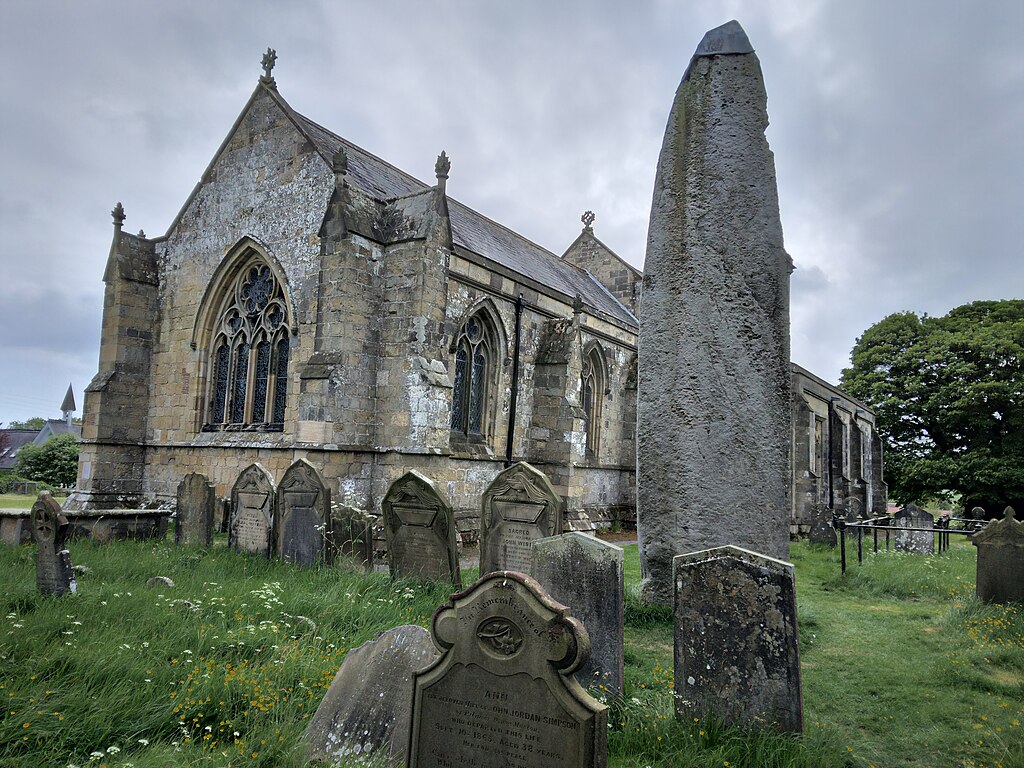
The Rudston Monolith at over 25 feet (7.6 m) is the tallest monolith (standing stone) in the United Kingdom. It is situated in the churchyard in the village of Rudston (grid reference TA 098 678) in the East Riding of Yorkshire. The stone is slender, with two large flat faces. It is approximately 5 feet 9 inches (1.75 m) wide and just under 3 feet 3 inches (1 m) thick. The top appears to have broken off the stone. If pointed, the stone would originally have stood around 28 feet (8.5 m). In 1773, the stone was capped in lead; this was later removed, though the stone is currently capped. The weight is estimated at 40 tonnes. The monolith is made of gritstone. The nearest source for the stone (Cayton or Cornelian Bay) is 9.9 miles (16 km) north of the site, although it may have been brought naturally to the site as a glacial erratic. The monument dates to the Late Neolithic or Early Bronze Age. A possible fossilised dinosaur footprint is said to be on one side of the stone, though a study by English Heritage in 2015 concluded that the claim was unsubstantiated.
There is one other smaller stone, of the same type, in the churchyard, which was once situated near the large stone. The Norman church was almost certainly intentionally built on a site already considered sacred, a practice common through the country – indeed the name of Rudston comes from the Old English “Rood-stane”, meaning “cross-stone”, implying that a stone already venerated was adapted for Christian purposes. The many other prehistoric monuments in the area include four cursuses, three of which appear to converge on the site of the monolith.
William Stukeley found “the dimensions of the monolith within ground as large as those without”.[4] Stukeley found many skulls during his dig and suggested they might have been sacrificial. Thomas Waller states that in 1861, during levelling of the churchyard, the surface of the ground near the monolith was raised 5 feet (1.5 m). (Historic England and Wikipedia)
(Ridiculopathy Photo)
The Rudston Monolith. In the Church (All Saints) Yard Rudston. Approximately 8m above ground it is Britain’s tallest standing stone. It’s weight is estimated at 40 tonnes. In the late 18th century tests revealed that there is as much again of the stone buried in the ground. Dating from 2000 BC, the stone is believed to come from near Whitby.
(Farz brujunet Photo)
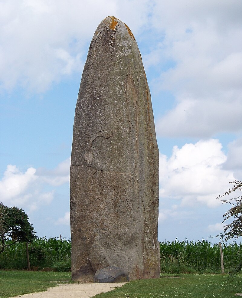
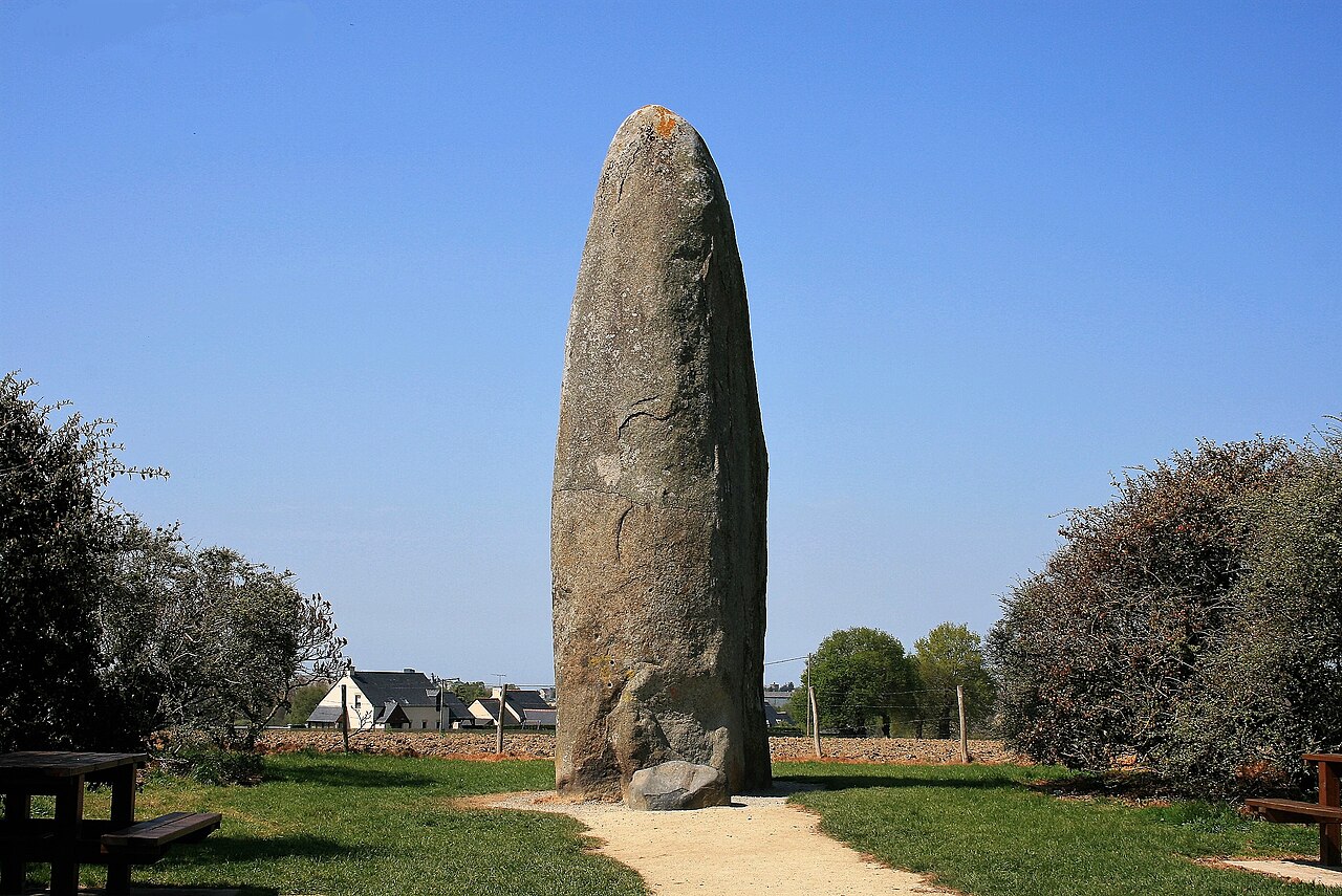
The Menhir de Champ-Dolent (Breton: Maen-hir dolenn) is a menhir, or upright standing stone, located in a field outside the town of Dol-de-Bretagne. It is the second largest standing stone in Brittany and is around 9.4 metres high. The Menhir de Champ-Dolent is 2 kilometres (1 mile) south of Dol-de-Bretagne in the department of Ille-et-Vilaine.
The menhir is the second tallest of Brittany’s standing stones. Its height above ground is between 9.3 and 9.5 metres (about 31 feet). It is made of pinkish granite, quarried about 2.5 mi (4.0 km) away, and has an estimated weight of around 100 tonnes. It is oval in shape with a smooth surface. A cross was once placed on top to Christianize it. It is not precisely dated, but recent scholarship suggests that Brittany’s menhirs were erected c. 5000–4000 BC. It has been registered as a monument historique by the French Ministry of Culture since 1889. According to tradition, in the year 560, Chlothar I, King of the Franks, is said to have met his rebel son, Chram, here. (Pozzi, Alberto (2014). Megalithism: Sacred and Pagan Architecture in Prehistory. Universal. p. 328. Wikipedia)
(Espirat Photo)
The Menhir de Champ-Dolent.

(Photo copyright Ian Moss)
The Ring of Brodgar, shown here, is a Neolithic henge and stone circle in Mainland, Orkney, Scotland. It is the only major henge and stone circle in Britain which is an almost perfect circle. Most henges do not contain stone circles; Brodgar is a striking exception, ranking with Avebury and Stonehenge among the greatest of such sites. The ring of stones stands on a small isthmus between the Lochs of Stenness and Harray. These are the northernmost examples of circle henges in Britain. Unlike similar structures such as Avebury, there are no obvious stones inside the circle, but since the interior of the circle has never been excavated by archaeologists, the possibility remains that wooden structures, for example, may have been present. The site has resisted attempts at scientific dating and the monument’s age remains uncertain. It is generally thought to have been erected between 2500 BC and 2000 BC, and was, therefore, the last of the great Neolithic monuments built on the Ness. (Wikipedia)

(Fog76 Photo)
One of the four Devil’s Arrows. These are four standing stones or menhirs in an alignment approximately 660 feet (200 m) to the east of the A1(M), adjacent to Roecliffe Lane, Boroughbridge in North Yorkshire, England. Erected in prehistoric times and distinctively grooved by millennia of rainfall, the tallest stone is 22.5 feet (6.85 m) in height, making this the tallest menhir in the United Kingdom after the 25 feet (7.6 m) tall Rudston Monolith in the East Riding of Yorkshire. The other two stones are 22 feet (6.7 m) and 18 feet (5.5 m) tall respectively, and it is thought that the alignment originally included up to five stones. (Wikipedia)
Standing Stones, Menhirs, and ancient stone circles
A menhir is a large human-made upright stone, typically dating from the European middle Bronze Age. They can be found individually as monoliths, or as part of a group of similar stones. Menhirs’ size can vary considerably, but they often taper toward the top.They are widely distributed across Europe, Africa and Asia, but are most numerous in Western Europe; particularly in Ireland, Great Britain, and Brittany, where there are about 50,000 examples, and northwestern France, where there are some 1,200 further examples. Standing stones are usually difficult to date. They were constructed during many different periods across pre-history as part of the larger megalithic cultures in Europe and near areas. Some menhirs stand next to buildings that have an early or current religious significance. Where menhirs appear in groups, often in a circular, oval, henge or horseshoe formation, they are sometimes called megalithic monuments. These are sites of ancient religious ceremonies, sometimes containing burial chambers. The exact function of menhirs has provoked more debate than practically any other issue in European pre-history. Over the centuries, they have variously been thought to have been used by Druids for human sacrifice, used as territorial markers, or elements of a complex ideological system, used as mnemonic systems for oral cultures, or functioned as early calendars. Until the 19th century, antiquarians did not have substantial knowledge of prehistory, and their only reference points were provided by classical literature. The developments of radiocarbon dating and dendrochronology have significantly advanced scientific knowledge on the subject. The word menhir was adopted from French by 19th-century archaeologists.
The introduction of the word into general archaeological usage has been attributed to the 18th-century French military officer Théophile Corret de la Tour d’Auvergne. It is a combination of two words of the Breton language: maen and hir. In modern Welsh, they are described as maen hir, or “long stone”. In modern Breton, the word peulvan is used, with peul meaning “stake” or “post” and van which is a soft mutation of the word maen which means “stone”. In Germany and Scandinavia the word Bauta is used (e.g. Bautastein) and this occasionally makes its way into English with the term “bauta stone”. Almost nothing is known of the social organization or religious beliefs of the people who erected the menhirs. Their language is also unknown. It is known, however, that they buried their dead and had the skills to grow crops, farm and make pottery, stone tools and jewelry. Identifying the purpose or use of menhirs remains speculative. Until recently, standing stones were associated with the Beaker people, who inhabited Europe during the European late Neolithic and early Bronze Age – later third millennium BC, c. 2800–1800 BC. However, recent research into the age of megaliths in Brittany strongly suggests a far older origin, perhaps back to six to seven thousand years ago.
Many menhirs are engraved with megalithic art. This often turned them into anthropomorphic stelae, although images of objects such as stone axes, ploughs, shepherds’ crooks, and yokes were common. With the exception of the stone axe, none of these motifs are definitely portraying what they are named after, and the name used to describe them is largely for convenience. Some menhirs were broken up and incorporated into later passage graves, where they had new megalithic art carved with little regard for the previous pictures. It is not known if this re-use was deliberate or if the passage grave builders just saw menhirs as a convenient source of stone (Le Roux 1992).During the Middle Ages, standing stones were believed to have been built by the giants who lived before the biblical flood. Many of the megaliths were destroyed or defaced by early Christians; it is estimated that some 50,000 megaliths once stood in Northern Europe, where almost 10,000 now remain. In 2019, four menhirs and nearly 1,000 small and big dolmens were found in India at the Pothamala hills at the Kerala-Tamil Nadu border. It is believed that the practitioners of the megalithic faith travelled via the sea, as the mass majority of menhirs are located on coasts, islands, and peninsulas. (Wikipedia)

(Wilson44691 Photo)
The Standing Stones of Stennes
The Standing Stones of Stenness is a Neolithic monument five miles northeast of Stromness on the mainland of Orkney, Scotland. This may be the oldest henge site in the British Isles. Various traditions associated with the stones survived into the modern era and they form part of the Heart of Neolithic Orkney World Heritage Site.The surviving stones are sited on a promontory at the south bank of the stream that joins the southern ends of the sea loch Loch of Stenness and the freshwater Loch of Harray. The name, which is pronounced stane-is in Orcadian dialect, comes from Old Norse meaning stone headland.
Although the site today lacks the encircling ditch and bank, excavation has shown this site was a henge monument, possibly the oldest in the British Isles. The stones are thin slabs, approximately 30 cm (12 in) thick with sharply angled tops. Four, up to about 5 m (16 ft) high, were originally elements of a stone circle of up to 12 stones, laid out in an ellipse about 32 m (105 ft) diameter on a levelled platform of 44 m (144 ft) diameter surrounded by a ditch. The ditch is cut into rock by as much as 2 m (6.6 ft) and is 7 m (23 ft) wide, surrounded by an earth bank, with a single entrance causeway on the north side. (Wikipedia)

(Marta Gutowska Photo)
.jpeg)
(Chmee2 Photo)
The Callanish Stones are an arrangement of standing stones placed in a cruciform pattern with a central stone circle. They were erected in the late Neolithic era, and were a focus for ritual activity during the Bronze Age. They are near the village of Callanish on the west coast of Lewis in the Outer Hebrides, Scotland. The Callanish Stones consist of a stone circle of thirteen stones with a monolith near the middle. Five rows of standing stones connect to this circle. Two long rows of stones running almost parallel to each other from the stone circle to the north-northeast form a kind of avenue. In addition, there are shorter rows of stones to the west-southwest, south and east-northeast. The stones are all of the same rock type, namely the local Lewisian gneiss. Within the stone circle is a chambered tomb to the east of the central stone. (Wikipedia)

(Chris Photo)
Aerial view of the Ring of Brodgar.
Silbury Hill

(OrionSM Photograph)
Silbury Hill with a view of flood waters making it appear as an island, courtesy of Simon Man’w.

(Dick Bauch Photo)
Silbury Hill is a prehistoric artificial chalk mound near Avebury in the English county of Wiltshire. It is part of the Stonehenge, Avebury and Associated Sites UNESCO World Heritage Site. At 39.3 metres (129 ft) high, it is the tallest prehistoric man-made mound in Europe[2] and one of the largest in the world; similar in volume to contemporary Egyptian pyramids. Silbury Hill is part of the complex of Neolithic monuments around Avebury, which includes the Avebury Ring and West Kennet Long Barrow. Its original purpose is still debated. Several other important Neolithic monuments in Wiltshire in the care of English Heritage, including the large henges at Marden and Stonehenge, may be culturally or functionally related to Avebury and Silbury.
Composed mainly of chalk and clay excavated from the surrounding area, the mound stands 40 metres (131 ft) high and covers about 2 hectares (5 acres). The hill was constructed in several stages between c.2400–2300 BC and displays immense technical skill and prolonged control over labour and resources. Archaeologists calculate that it took 18 million man-hours, equivalent to 500 men working for 15 years to deposit and shape 248,000 cubic metres (324,000 cu yd) of earth and fill. Euan Mackie asserts that no simple late Neolithic tribal structure as usually imagined could have sustained this and similar projects, and envisages an authoritarian theocratic power elite with broad-ranging control across southern Britain. The base of the hill is circular and 167 metres (548 ft) in diameter. The summit is flat-topped and 30 metres (98 ft) in diameter. A smaller mound was constructed first, and in a later phase much enlarged. The initial structures at the base of the hill were perfectly circular: surveying reveals that the centre of the flat top and the centre of the cone that describes the hill lie within a metre of one another. There are indications that the top originally had a rounded profile, but this was flattened in the medieval period to provide a base for a building, perhaps with a defensive purpose.[9]The first clear evidence of construction, dated to around 2400 BC,[10] consisted of a gravel core with a revetting kerb of stakes and sarsen boulders. Alternate layers of chalk rubble and earth were placed on top of this: the second phase involved heaping further chalk on top of the core, using material excavated from a series of surrounding ditches which were progressively refilled then recut several metres further out.[6] The step surrounding the summit dates from this phase of construction, either as a precaution against slippage,[11] or as the remnants of a spiral path ascending from the base, used during construction to raise materials and later as a processional route. (Wikipedia)
The prehistoric chalk mound of Silbury Hill in Wiltshire can be seen from the prehistoric stone circle at Avebury, which is older – and larger – than the one at Stonehenge. In the early 11th-Century, with southern England under pressure from Scandinavian armies looking to extort tribute (the notorious ‘Danegeld’), Silbury Hill was pressed into use.This artificial hill was fortified with a timber palisade and served as a lookout site/warning beacon against the Danes.The watchmen on Silbury Hill were well-connected. Not only did they overlook the old Roman road between London and Bath (today’s A4), they were also close to a ‘here-path’ (army path) not far from where it intersected the prehistoric route known as the Ridgeway. From their platform on top of Silbury Hill, the watchmen could see the beacons that monitored movement on the Marlborough Downs: at Marlborough itself; Avebury; Yatesbury – the only Anglo-Saxon beacon that’s been archaeologically ‘proved’ so far; and Totterdown (originally Tot-aern-dun, meaning Look-out House Hill). (John Baker and Stuart Brooks on beacons)

(Lisa G Bayer Photo)
Silbury Hill with associated archaeological sites in the Avebury region ca. 2600 to 2300 BC.
Uffington White Horse

(Graham Phillips Photo)
The Uffington White Horse is a prehistoric hill figure, 110 m (360 ft)[1] long, formed from deep trenches filled with crushed white chalk. The figure is situated on the upper slopes of Whitehorse Hill in the English civil parish of Uffington in Oxfordshire, some 16 km (10 mi) east of Swindon, 8 km (5.0 mi) south of the town of Faringdon and a similar distance west of the town of Wantage; or 2.5 km (1.6 mi) south of Uffington. The hill forms a part of the scarp of the Berkshire Downs and overlooks the Vale of White Horse to the north. The best views of the figure are obtained from the air, or from directly across the Vale, particularly around the villages of Great Coxwell, Longcot, and Fernham. The Uffington White Horse was created some time between 1380 and 550 BC, during the late Bronze Age or early Iron Age. The site is owned and managed by the National Trust and is a scheduled monument. The Guardian stated in 2003 that “for more than 3,000 years, the Uffington White Horse has been jealously guarded as a masterpiece of minimalist art. The Uffington Horse is by far the oldest of the white horse figures in Britain; the others inspired by it have an entirely different design. (Wikipedia)
Long barrows are a style of monument constructed across Western Europe in the fifth and fourth millennia BCE, during the period. Typically constructed from earth and either timber or stone, those using the latter material represent the oldest widespread tradition of stone construction in the world. Around 40,000 long barrows survive today.
The structures have a long earthen tumulus or “barrow”, that is flanked on two sides with linear ditches. These typically stretch for between 20 and 70 metres in length, although some exceptional examples are either longer or shorter than this. Some examples have a timber or stone chamber in one end of the tumulus. These monuments often contained human remains interred within their chambers, and as a result, are often interpreted as , although there are some examples where this appears not to be the case. The choice of timber or stone may have arisen from the availability of local materials rather than cultural differences. Those that contained chambers inside of them are often termed chambered long barrows while those which lack chambers are instead called unchambered long barrows or earthen long barrows.
The earliest examples developed in Iberia and western France during the mid-fifth millennium BCE. The tradition then spread northwards, into the British Isles and then the Low Countries and southern Scandinavia. Each area developed its own variations of the long barrow tradition, often exhibiting their own architectural innovations. The purpose and meaning of the barrows remains an issue of debate among archaeologists. One argument is that they are religious sites, perhaps erected as part of a system of ancestor veneration or as a religion spread by missionaries or settlers. An alternative explanation views them primarily in terms, as territorial markers delineating the areas controlled by different communities as they transitioned toward farming.
Communities continued to utilise these long barrows long after their construction. In both the Roman period and the Early Middle Ages, many long barrows were reused as cemeteries. Since the sixteenth century they have attracted interest from antiquarians and ; it is from the excavation of the latter that our knowledge about them derives. Some have been reconstructed and have become tourist attractions or sacred sites used for rituals by and other religious groups

The distribution of known Early Neolithic long barrows and related funerary monuments.

(Steffen Heilfort Photo)
Le Menec alignments at Carnac.

(Vanbasten 23 Photo)
Le Menec alignments at Carnac.

(Superbass Photo)
Standing stones of Carnac: Alignement at Kerlescan, Carnac, Brittany.

(PtrQs)
Standing stones of Carnac: Alignement at Kerlescan, Carnac, Brittany.
The Standing Stones at Carnac, France
The Carnac stones are an exceptionally dense collection of megalithic sites near the south coast of Brittany in northwestern France, consisting of stone alignments (rows), dolmens (stone tombs), tumuli (burial mounds) and single menhirs (standing stones). More than 3,000 prehistoric standing stones were hewn from local granite and erected by the pre-Celtic people of Brittany and form the largest such collection in the world. Most of the stones are within the Breton municipality of Carnac, but some to the east are within neighboring La Trinité-sur-Mer.
The stones were erected at some stage during the Neolithic period, probably around 3300 BC, but some may date to as early as 4500 BC. The question of which people Carnac stones are to be attributed to is still debated. There are three major groups of stone rows – Ménec, Kermario and Kerlescan. They may have once formed a single group but have been split up as stones were removed for other purposes. The standing stones are made of weathered granite from local outcroppings that once extensively covered the area. (Wikipedia)

(intofarlands Photo)

(Histories Mysteries Photos)
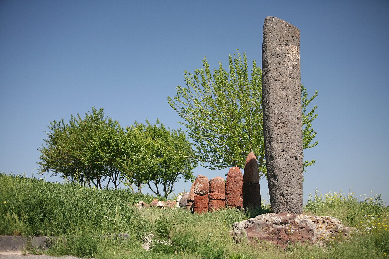
The Hartashen Megalithic Avenue
Hartashen Megalithic Avenue is a prehistoric megalithic monument in Armenia. There are two avenues of megalithic rocks which do not intersect. These avenues are composed of basalt stones which are placed at an angle, and menhirs are arranged in three rows in each. There is no clarity about the purpose of these three rows of menhirs and further research is under progress. There is no firm dating of the monument. It has been attributed in recent years to anti tank defences constructed in the Second World War, but recent research favours an interpretation that the site, if not its arrangement, dates to the neolithic or bronze age and perhaps shares a context with the Carnac stones of France.
The monument comprises 760 preserved steles. Some steles have been disturbed, and it is estimated there may have been up to 1200 originally. The flat surface between the monuments comprises an unexcavated funerary monument. No connection has been discovered between the avenue and the funerary monuments. The rows of stele begin at a rocky outcrop and follow the valley topography for 500 metres. The monument is not astronomically aligned, nor aligned with any features within the topography.The arrangement of the stone rows were integrated into a modern anti tank military barrier. As there is no firm dating, it is unknown to what extent and in what form the avenues predate this modern use. (Wikipedia)
.jpeg)
(Michael aus Halle)
Externsteine.

(Daniel Schwen Photo)
Externsteine.

(Bene Phloto)
Externsteine, aerial view.
In the early decades of the twentieth century, two German researchers Wilhelm Teudt and Josef Heinsch claimed that ancient Teutonic peoples contributed to the construction of a network of astronomical lines, called “Heilige Linien” (Holy lines), which could be mapped onto the geographical layout of ancient or sacred sites. According to Teudt, the region of Teutoburger Wald has astronomical lines connecting sacred sites, concentrated around the rock formation called Die Externsteine and located in Lower Saxony, in the center of Germany and was a very special place, the sacred heartland of the land. The area of ‘Teutberger Wald’, also known as the ‘German heartland’ has a significant network of these lines which include the Externsteine.

(Kenny Arne Lang Antonsen Image)
The Goseck Henge is an early Neolithic Henge-structure with entrances orientated to the rising and setting winter solstice sun. At c. 5,000 BC, the Goseck ‘Henge’ is considered the earliest solar observatory currently known in the world. It lies on the same latitude as Stonehenge, at just over 1′ minute of longitude further north (approx 1000m ). The Stonehenge ‘Post-holes’ are dated at least a thousand years earlier than this monument, but the Henge is considerably older than the one in England.

(Ralf Boutragel Photo)
The Goseck Circle (German: Sonnenobservatorium Goseck) is a Neolithic structure in Goseck in the Burgenlandkreis district in Saxony-Anhalt, Germany. Its construction is dated to approximately 4900 B.C., and appears to have remained in use until about 4700 B.C. Thus, it may be the oldest and best known of the circular enclosures associated with the Central European Neolithic. Currently, the site is presented officially by the state archaeologists and the local association that looks after it as a ritual or cult structure. The circle consists of a concentric ditch 75 metres (246 feet) across and two palisade rings containing entrances in places aligned with sunrise and sunset on the winter solstice days and smaller entrances aligned with the summer solstice. Marketing materials have described the site as one of the oldest “Solar observatories” in the world, but sunrise and sunset during winter and summer solstices are the only evident astronomical alignments emphasized in the remains of the structure. The existence of the site was made public in August 2003. It was opened for visitors in December 2005. (Wikipedia)

(Ch. Pagenkopf Photo)
Dolmen near Rarik.
In the area of present-day Mecklenburg-Vorpommern, Germany, up to 5,000 megalith tombs were erected as burial sites by people of the Neolithic Funnelbeaker (TRB) culture. More than 1,000 of them are preserved today and protected by law. Though varying in style and age, megalith structures are common in Western Europe, with those in Mecklenburg-Vorpommern belonging to the youngest and easternmost—further east, in the modern West Pomeranian Voivodeship of Poland, monuments erected by the TRB people did not include lithic structures, while they do in the south (Brandenburg), west (Lower Saxony and Schleswig-Holstein) and north (Denmark).Though megaliths are distributed throughout the state, their structure differs between regions. Most megaliths are dolmens, often located within a circular or trapezoid frame of singular standing stones. Locally, the dolmens are known as Hünengräber (“giants’ tombs”) or Großsteingräber (“large stone tombs”), their framework is known as Hünenbett (“giants’ bed”) if trapezoid or Bannkreis (“spellbind circle”) if circular. The materials used for their construction are glacial erratics and red sandstones. 144 tombs have been excavated since 1945. The megaliths were used not only by the bearers of the TRB culture, but also by their successors, and have entered local folklore.
The megaliths in Mecklenburg-Vorpommern were erected as burial sites in the Neolithic, by the bearers of the Funnelbeaker (TRB) culture, between 3,500 and 3,200 BC. Initially, the TRB people buried their dead in pits, often covered with mounds of clay. Later, they erected dolmens for this purpose, but also continued the use of flat graves. All megaliths were erected during a relatively short time period, spanning about 200 years or about seven generations, with the oldest ones dating to phase C of the Early Neolithic, while most were built in the beginning of the Middle Neolithic.The dolmens were built from glacial erratics, with the gaps filled with red sandstone. Presumably, standing stones were transported to the site using rollers, slides, levers and ropes, and the interior of the unfinished dolmens was filled with clay to form a ramp to enable the movement of the cover stones into their final position. After removing the clay from the interior, a barrow (tumulus) was then raised on top of the dolmen, which remained accessible through a passage made from smaller stones. In addition, single standing stones were sometimes placed around the dolmen, forming either a rectangular or trapezoidal shape (Hünenbett), or a stone circle (Bannkreis). Sometimes, large singular “guardian stones” (Wächterstein, Bautastein) were placed adjacent to these shapes. The interior of the dolmen was usually divided into small compartments by slabs of red sandstone, standing upright. (Wikipedia)


(Sémhur Photos)
La Roche-aux-Fées, Brittany, France
La Roche-aux-Fées (The Fairies’ Rock) is a Neolithic gallery grave, or dolmen, located in the commune of Essé, in the French department of Ille-et-Vilaine in Brittany. Its name comes from a legend that claims that the stones were placed by fairies. The dolmen consists of more than forty stones forming a corridor four times longer than wide. Its northwest–southeast axis is on an alignment with sunrise at the winter solstice.The tomb is one of the most famous and largest neolithic dolmens in Brittany. It consists of a covered passage of stone blocks, with roofing stones laid across them. It is about 20 metres long, and there are around 48 blocks, of which the heaviest weighs about 45 tonnes. the interior is divided into two separate chambers. The entrance is aligned with the rising sun at the winter solstice. The original structure would have been covered with a mound of stones and earth. It is thought to date from between 3000 and 2500 BC. (Wikipedia)
Barbour, Philippe (2005). Brittany. New Holland. p. 87.

(History Timeline Photo)
Rujm el-Hiri
Rujm al-Hiri (also known as the “Stonehenge of the Levant”) is a prehistoric megalithic site ocated in the Israeli-occupied region of the Golan Heights, approximately 16 kilometers east of the shores of the Sea of Galilee near the borders of Syria and Israel. Dating back to the 3rd millennium BCE, this site consists of a massive, circular arrangement of stones, with a central burial mound surrounded by concentric rings of large basalt stones. The structure’s purpose is still debated, but it is believed to have had astronomical, ceremonial, or religious significance, similar to other megalithic sites like Stonehenge in Britain. Rujm al-Hiri spans about 500 meters in diameter, with stones weighing up to 10 tons, and its layout is thought to align with solstitial events, suggesting a potential role in ancient calendar or time-keeping systems. The site is a testament to the advanced engineering and social organization of its builders during the Early Bronze Age, and it remains one of the most mysterious and impressive archaeological sites in the Levant.

(Nick Woolley Photo)
Castlerigg Stone Circle, situated on a prominent hill to the east of Keswick, in the Lake District National Park, North West England. It is one of around 1,300 stone circles in the British Isles and Brittany, constructed as a part of a megalithic tradition that lasted from approximately 3,200 BC to 2500 BC, during the Late Neolithic and Early Bronze Ages.

(Paul Allison Photo)
The Penrhos Feilw Standing Stones are a pair of standing stones on Holy Island west of Anglesey in north-west Wales. They are thought to date from the Bronze Age but their origins and purpose are unclear. They are about 3 m (10 ft) high and are a similar distance apart.

(Derek Harper Photo)
Mitchell’s Fold is a Bronze Age stone circle in southwest Shropshire, located near the small village of White Grit on dry heathland at the southwest end of Stapeley Hill in the civil parish of Chirbury with Brompton, at a height of 1083 ft (330m) o.d.
%252C_Oxfordshire_-_geograph.org.uk_-_605683.jpeg)
(Brian Robert Marshall Photo)
The Rollright Stones are a complex of three Neolithic and Bronze Age megalithic monuments near the village of Long Compton, on the borders of Oxfordshire and Warwickshire. Constructed from local oolitic limestone, the three monuments, now known as the King’s Men and the Whispering Knights in Oxfordshire and the King Stone in Warwickshire, are distinct in their design and purpose. They were built at different periods in late prehistory. During the period when the three monuments were erected, there was a continuous tradition of ritual behaviour on sacred ground, from the 4th to the 2nd millennium BCE.

(Alan Simpkins Photo)
The Longstones are two standing stones, one of which is the remains of a prehistoric ‘cove’ of standing stones, close to Beckhampton in Avebury parish, in the English county of Wiltshire.
Withypool Stone Circle is a stone circle located near to the village of Withypool in the south-western English county of Somerset. It is found within Exmoor. The Withypool ring is part of a tradition of stone circle construction that spread throughout much of Britain, Ireland, and Brittany during the Late Neolithic and Early Bronze Age, over a period between 3,300 and 900 BCE. The purpose of such monuments is unknown, although archaeologists speculate that they were likely religious sites, with the stones perhaps having supernatural associations for those who built the circles.

(Mark McGaughey Photo)
Beltany is a Bronze Age stone circle just south of Raphoe town in County Donegal, Ireland. It dates from circa 2100-700 BC. There is evidence that it may also have been the sacred site of Neolithic monuments, possibly early passage tombs. It overlooks the now destroyed passage tomb complex at Kilmonaster and Beltany is dominated by Croghan Hill to the east on the summit of which there sits a Neolithic mound most likely a passage tomb (though never excavated).
Today Beltany has 64 stones of varying height and width enclosing an earthen platform. The centre is greatly disturbed and most likely was the result of digging by locals in 1700s for available loose stones to build farmsteads and field boundaries. This evidence was given orally to the Ordnance Survey field officers in 1830s which is written into the OS records. It states that locals recalled the removal of vast heaps of stone and sepulchral type graves with bones. The boulder wall close to the circle may support this evidence and the mention in OS early maps of ‘Tops Village’ at the foot of the hill. The enigmatic Stone Circle is situated on the summit of Tops Hill, the anglicized Gaelic word meaning ‘the lighting of a ceremonial torch’. Several stones are cupmarked. One in particular, the triangle stone on NE is decorated with circular incisions or cup marks visible to naked eye. Other stones have what appears to be replicated star constellations. The heavy stones on NW lean outwards possibly from pressure of the earlier debris and boulders removed in 1700s or due to depletion of earthen bank.
This was a ritual site associated with marking the agricultural Celtic year – the summer and winter Solstices and Equinox. The Celtic Ritual Year was in 4 parts – Beltaine (May), Samhain (November) the main parts and Imbolg (February) and Lughnasa (August). Beltany may be linked to marking both sunrise and sunset at these important ritual and ceremonial events in the year. It may also have a lunar orientation, yet to be calculated.
A single ‘outlier’ stone about 2 metres high stands to the southeast of the circle. It probably had some function related to the rituals or ceremonies in the circle. Or it may be one of the several line standing stones found in fields around the slopes of Tops hill and valley.
A carved stone head (flat to back) is believed to have come from lands around Beltany and thought to have functioned as either a mask or a mould from which ceremonial masks were fashioned in bronze or even gold. It is in the vaults at the National Museum in Dublin. These megaliths indicate that this landscape was marked out and used as a sacred and ritual site for several millennia.
.jpeg)
(Eugene Birchall Photo)
Glastonbury Tor is a conical hill of clay and Blue Lias near Glastonbury in the English county of Somerset, rising to an elevation of 518 feet (158 m). The remains of the roofless St Michael’s Tower stand at the top. The sides of the Tor have seven deep, roughly symmetrical terraces, or lynchets. Although their formation remains a mystery, it is possible that the terraces are the remains of a medieval “spiral walkway” created for pilgrims to reach the church on the summit. Another suggestion is that the terraces are the remains of a three-dimensional labyrinth, a design found all over the Neolithic world, can be easily transposed onto the Tor so that by walking around the terraces a person eventually reaches the top in the same pattern. A labyrinth would very likely place the terraces in the Neolithic era.
The Tor is mentioned in Celtic mythology, particularly in myths linked to King Arthur, and has several other enduring mythological and spiritual associations. The slopes of the hill are terraced, but the method by which they were formed remains unexplained. Artefacts from human visitation have been found, dating from the Iron Age to Roman eras. Several buildings were constructed on the summit during the Saxon and early medieval periods; they have been interpreted as an early church and monks’ hermitage. The head of a wheel cross dating from the 10th or 11th century has been recovered. The original wooden St Michael’s Church was destroyed by an earthquake on 11 September 1275.

(Rodw Photo)
The stone Church of St Michael was built on the site in the 14th century. St Michael’s Church survived until the Dissolution of the Monasteries in 1539 when, except for the tower, it was demolished. Its tower remains, although it has been restored and partially rebuilt several times. There are many myths and legends associated with the Tor. It has been linked to Avalon and also with King Arthur, since the alleged discovery of King Arthur and Queen Guinevere’s neatly labeled coffins in 1191.
Glastonbury Zodiac

The Glastonbury Zodiac may be the most remarkable ancient earthen work in Great Britain. This great landscape configuration is comprised of a circle 10 miles across and 30 miles in circumference formed by hills, roads, and rivers that can only be seen in its entirety from high above. Discovered in1927 by Katherine Maltwood, the figures are representations of constellations in the heavens moulded into the fabric of the land. Here giant mythological archetypes depict the Grail Quest. Like the Twelve Giants, the Round Table has twelve places. Even the land around Glastonbury has been known for centuries as the Twelve Hides (given to Joseph of Arimathea the uncle of Jesus, when he arrived here with the Holy Grail).
This vast complex encompasses Glastonbury Tor and Chalice Hill in the sign of Aquarius (Phoenix), Wearyall Hill in Pisces, and so forth, as it weaves round the Isle of Avalon. Arthur, Guinevere, Merlin, and the Knights are still remembered in the signs of the Giant Zodiac.
Maltwood believed the Zodiac was constructed sometime around 2700 BCE, but earlier dates of 7000 BCE relating to Egypt’s Dendarah Zodiac, have also been suggested. (Internet:http://images.google.ca/imgres?imgurl=http://www.labyrinthina.com/glaszodiac)
5,000-year-old sun calendar in southern Alberta

Bob Weber
THE CANADIAN PRESS
EDMONTON – An academic maverick is challenging conventional wisdom on Canada’s prehistory by claiming an archeological site in southern Alberta is really a vast, open-air sun temple with a precise 5,000-year-old calendar predating England’s Stonehenge and Egypt’s pyramids. Mainstream archeologists consider the rock-encircled cairn to be just another medicine wheel left behind by early aboriginals. But a new book by retired University of Alberta professor Gordon Freeman says it is in fact the centre of a26-square-kilometre stone “lacework” that marks the changing seasons and the phases of the moon with greater accuracy than our current calendar. “Genius existed on the prairies 5,000 years ago,” says Freeman, the widely published former head of the university’s physical and theoretical chemistry department.
Freeman’s fascination with prairie prehistory dates back tohis Saskatchewanboyhood. He and his father would comb the short grasses of the plains in searchof artifacts exposed by the scouring wind. That curiosity never left him and hereturned to it as he prepared to retire from active teaching. Looking fora hobby, he asked a friend with an interest in history to suggest a fewintriguing sites to visit. On a warm late-August day in 1980, that list drewhim to what he has come to call Canada’s Stonehenge,which is also the title of his book.
A central cairn atop one of a series of low hills overlooking the Bow River, about 70 kilometres east of Calgary, had been partially excavated in 1971 and dated at about 5,000 years old. But as he approached it, Freeman strongly felt there was much more there than previously thought. “As we walked toward the hilltop, I saw all kinds of patterns in the rocks on the way up. As I walked around the hilltop, I could see patterns that I doubted very much were accidental.”
Freeman photographed what he saw and showed the images to archeologists. They told him the rocks, some of which weigh up to a tonne, had been randomly distributed by melting glaciers. But those rocks and rock piles, Freeman said, had been “highly engineered,” shimmied and balanced and wedged in ways he couldn’t believe were natural. And so began a magnificent obsession – 28 years of photographing the site in summer and winter, observing the alignment of rocks and how they coincided with the recurring patterns of sun, moon and stars. Freeman estimates he and his wife Phyllis have spent a total of seven months living at the site. Twelve thousand photographs with precise times and dates are neatly catalogued in his files.
What he found: The central cairn is surrounded by 28 radiating stone lines, four of which align with the cardinal points of the compass. Those lines are encircled by another ring of stones. A few metres away lies a stone semicircle, with a large stone between it and the central cairn. The left edge of the semicircle lines up with both the central stone and the right edge of the cairn, and vice versa.
To Freeman, those features represent the sun, the crescent moon and the morning star. As well, there are secondary cairns on nearby hills and rock assemblages that seem to correspond to constellations. And after years of rising before dawn, in all seasons and weather, to carefully photograph the positions of the sun, Freeman found the rocks once thought to be simply strewn across the prairie instead mark the progression of the year with uncanny accuracy. The rising and setting sun on both the longest and shortest days of the year lines up precisely with V-shaped sights in the temple’s rocks. The spring and autumn equinoxes, when day and night are equal, are similarly marked. They are not the equinoxes of the Gregorian calendar currently used, however, but the true astronomical equinoxes. Freeman is convinced the temple contains a lunar calendar as well, because the 28 rays radiating from the central cairn correspond to the length of the lunar cycle. “I thought I would complete that study in a couple years,” says Freeman, a laughing, vigorous 78. “Twenty-eight years later we’re still making discoveries.”
Mainstream archeology hasn’t been exactly welcoming. Despite being highly regarded in his own field, Freeman says journals have rejected his papers and conferences have denied him a platform. Professionals in any field resist interlopers from other disciplines and archeology is no exception, he says. But he suggests conventional wisdom can restrict insight. “If you have preconceptions, you’re never going to discover anything.”
Although he hasn’t read “Canada’s Stonehenge,” University of Alberta archeologist Jack Ives is familiar with Freeman’s theories. He says recent research suggests some astronomical knowledge developed in Central and South America flowed north to the plains, where it was adapted by people for their own purposes. “There is some basis for thinking there was sophisticated astronomical knowledge,” says Ives.
But what exactly is manifested in the medicine wheels? “They may certainly reflect solstices and equinoxes. How much more sophisticated beyond that has been a subject of debate.” But Ives points out the terrain in question is an ancient glacial moraine, full of naturally occurring rocks. “You have to be very careful about what you line up.”
Freeman, however, is convinced. He looks forward to the academic debate to come. “I know my song well before I sing it,” he says, quoting Bob Dylan. Meanwhile, Freeman hopes to use any publicity generated by his book to push for preservation of the site. Part of it is privately owned, but most is Crown land and open to both the energy industry and casual, possibly destructive, visitors. “The place is so far away from anything that it’s not adequately protected.”
Freeman is a man of science, trained to trust hard data and believe evidence over sensation. But after 28years unravelling a message in mute stones, the wind in his hair and the sun on his face, absorbed in ancient mysteries, the site has come to evoke in him something akin to reverence. “I can go down there with a headache and within a day everything is gone. It’s just like a cure. There is something down there. I just don’t know how to describe it. “I just feel very comfortable there. I just feel comfortable.”

(Sonashen Photo)
Vishapakar in Metsamor, Armenia.
A vishapakar (Armenian: Վիշապաքար) also known as vishap stones, vishap stelae, “serpent-stones”, “dragon stones”, are characteristic monoliths found in large numbers in the Armenian Highlands, in natural and artificial ponds, and other sources of water. They are commonly carved from one piece of stone, into cigar-like shapes with fish heads or serpents. Supposedly they are images of vishaps, a water dragon of Armenian folklore. There are about 150 known extant vishap stelae, of which 90 are found in Armenia.
The stones are found in Armenia’s Gegham mountains, Lake Sevan’s north-east coast, Mount Aragats’s slopes, Garni, the valley of Çoruh River, as well as other places, where they used to worship Vishap stones in ancient times. They are obvious with “Vishap” names. They were carved from massive stones (the biggest being 5.06m high), in a fish form, with a snake, bull, ram, stork, etc., as well as bird sculptures, usually placed in fountains, canals, reservoirs, and artificial lakes nearby. It can be assumed that these slabs were supporting agriculture and irrigation, by worshipping personal water deities. (Wikipedia)
All the findings are carved on one stone,that is within 3-5m high. Most of the Vishaps are in a fish form that resemblesa catfish. Basically, the carved details represent the fish eyes, mouth, tail,and gills. Another portion of the Vishaps are pictured as a hoofed animal suchas a bull or ram and may represent a sacrifice, with various cases onlypictured as stakes on the stretched animal skin. On other Vishaps, there arewaves symbolizing water, which often come out of the mouth of the bull, long-leggedbirds, and rare snakes.
Three Main Types of Vishaps:
Bull form (square, thick plate form, the front is mainly a bull’s head andfallen down limbs image)
Fish form (oval, carved in the shape of the fish, contains features unique tothe fish anatomy)
Fish-Bull Form (contains both of the forms)
Most of the Vishap stones are found fallen down in a horizontal position, lyingdown. However, the three forms listed above are designed and carved on allsides. The tails of the fish forms of the Vishap stones suggests that they werealso once in a standing position.
The Vishaps are monuments used to worship water, which are believed to have aclose tie to water distribution. Almost all the Vishaps are found in placesrelated to mountain springs or canals. Similarly, there are irrigation systemsfound by Ashkharbek Kalantar at Mount Aragats, the Tokhmakagan backwaters ofthe Gegham mountains, Artanish Bay and near Gemerzek settlements. Although itis impossible to precisely date the irrigation systems, scientists have linkedthe Vishaps to ancient fertility and water worship. (Wikipedia)
(Mediacrat Photo)
Vishapakar near Metsamor museum.

(Clarke Payne)
Tucked beneath Armenia’s Geghama Mountains, the ancient “Dragon Stones” endure, over 5,000 years old. A towering stone, 13 feet (4 meters) high, bears intricate carvings of birds and a mystical face gazing skyward. The bird motifs mirror those at Göbekli Tepe, sparking questions about links between ancient cultures and their symbolic art.
%20-%20Copy.jpg)
.jpg)
Ishi no Hōden (石の宝殿); plate in Siebold’s Nippon (1832–) (Nippon II Tab. XXIII)
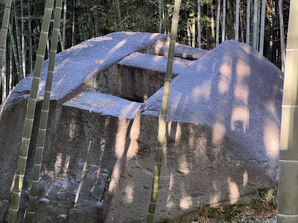
The Ishi no Hōden (石の宝殿) is a megalithic monument located in the grounds of the Ōshiko Jinja (生石神社), a Shinto shrine located in the city of Takasago, Hyōgo Prefecture in the Kansai region of Japan. The Ishi-no-Hōden is made from tuff and is surrounded on three sides by unprocessed bedrock. With a weight estimated at 500 tons, it measures 6.4 meters wide by 5.7 meters high by 7.2 meters in thickness. In shape, it is carved in the form of two flat rectangular parallelepipeds oriented vertically and sandwiching a small rectangular parallelepiped. One of the sides has a protrusion shaped like the top of a pyramid. The space between the surrounding bedrock and the megalith is wide enough for one adult to pass through, and it is possible to go around (admission fee is required). The monolith is situated in a large depression, which forms a pond at its base. The monolith is carved with a pillar at the center of its base, which is not visible at eye-level, so the monolith appears to be floating above the pond. Some estimate the stone was carved 14,000 years ago, but the actual date the monolith was carved, and by whom and for what purpose remain unknown. As with many sacred objects in Japan (including natural objects such as trees) the Ishi-no-Hōden megalith is adorned with a sacred rice-straw rope known as a shimenawa.

(Ancient Origins Photo)
Ishi no Hōden.
(Saigen Jiro Photo)
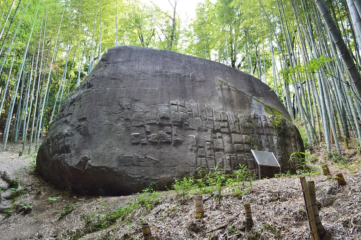
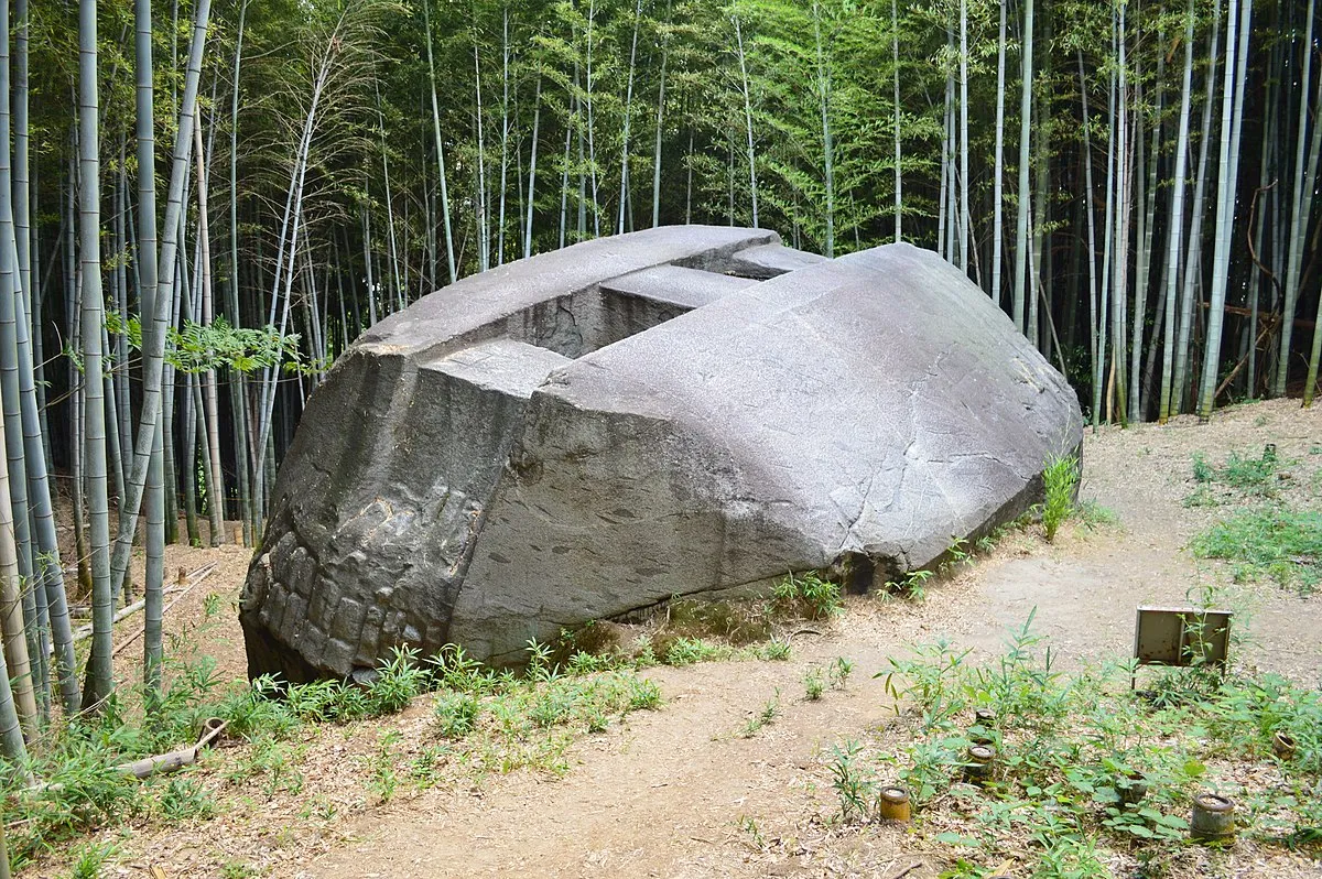
Masuda-no-Iwafune megalith in Asuka, Nara Prefecture. Also known as the “Rock Ship of Masuda” is located in in Kashihara, Nara Prefecture, Japan. The area is known for its carved granite stones, many of which are fashioned into the shape of human-like figures and animals. It’s uncertain when they were made, but some have argued they were built around the 7th century CE towards the end of the Kofun period.Collectively, the artworks are known as the Stoneworks of Asuka. They’re particularly interesting as they stand in contrast to the dominant style of Buddhist art that swept through Japan at the time.
The Rock Ship of Masuda, aka Masuda-no-iwafune, is the most unusual and large of them all. The carved stone measures 11 meters (36 feet) in length, 8 meters (26 feet) in width, and 4.7 meters (15 feet) in height – roughly comparable to the size of a luxury tour bus. Its unusual shape and size are especially impressive when you realize it was made out of granite, a notoriously tough rock that’s extremely difficult to cut and carve. Along with the square cut indents on top of the rock, it also features a square scale-like pattern on the side that’s also been intentionally carved. The exact purpose and construction of Masuda-no-Iwafune remain unknown.
(NARA Visitors Bureau Photos)
Masuda-no-Iwafune megalith in Asuka, Nara Prefecture, Japan.
(Hidden Inca Tours Photo)
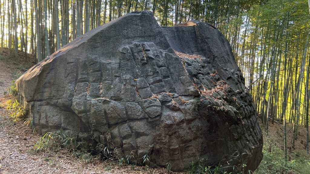
Other strange stone artifacts that do not fit the conventional Japanese historical paradigm include this finely shaped granite stone also in the Asuka area of Japan.
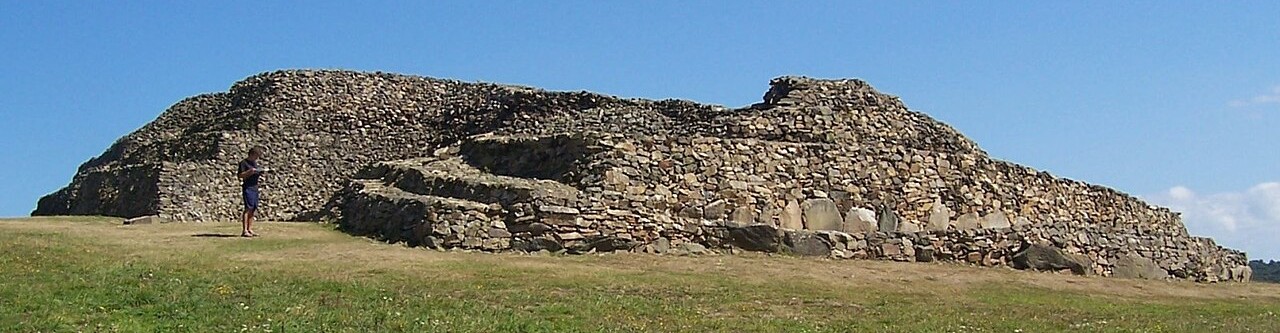
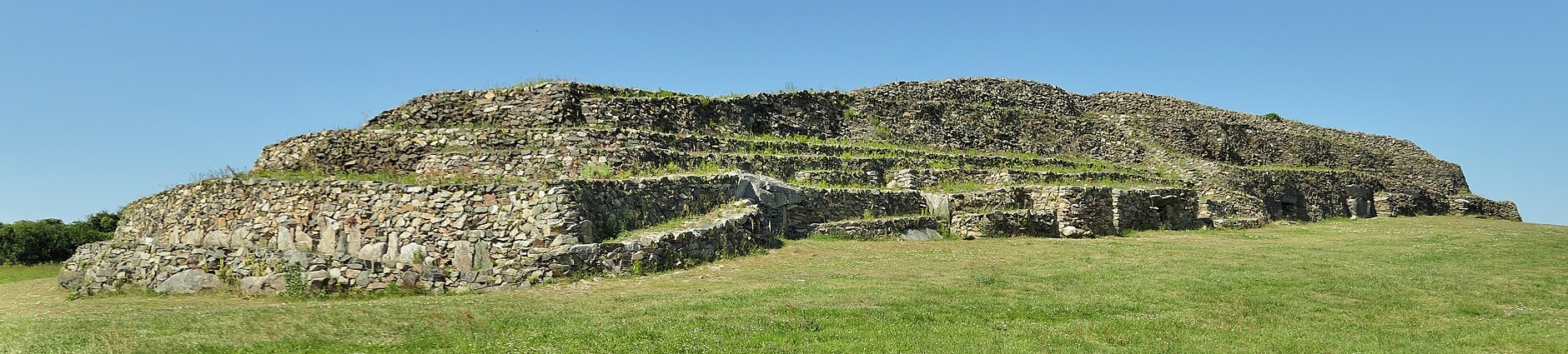
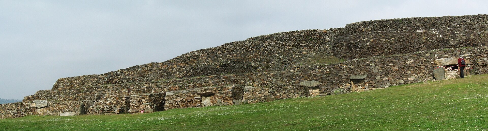
Cairn of Barnenez

Gerhard Haubold Photo)
The Cairn of Barnenez (also: Barnenez Tumulus, Barnenez Mound; in Breton Karn Barnenez; in French: Cairn de Barnenez or Tumulus de Barnenez) is a Neolithic monument located near Plouezoc’h, on the Kernéléhen peninsula in northern Finistère, Brittany, France. It dates to the early Neolithic, around 4000 BC. Along with the Tumulus of Bougon and Locmariaquer megaliths, also located in Great West France, it is one of the earliest megalithic monuments in Europe and one of the oldest man-made structures in the world. It is also remarkable for the presence of megalithic art.
Radiocarbon dates indicate that the first phase of the monument was erected between 4850 and 4250 BC, and the second phase between 4450 and 4000 BC. Pottery found in and around the monument indicates that it underwent a period of reuse in the Bronze Age, in the 3rd millennium BC.
The cairn was first mapped in 1807, in the context of the Napoleonic cadaster. Its first scientific recognition took place in the context of an academic congress in Morlaix in 1850, when it was classified as a tumulus. Privately owned until the 1950s, the cairn was used as a quarry for paving stones. This activity, which threatened to destroy the monument, was only halted after the discovery of several of its chambers in the 1950s. The local community then took control of the site. The cairn was restored between 1954 and 1968. At the same time, vegetation was removed from the mound and systematic excavation took place in and around the monument.
Today, the Barnenez cairn is 72 m long, up to 25 m wide, and over 8 m high. It is built of 13,000 to 14,000 tons of stone. It contains 11 chambers entered by separate passages. The mound has steep facades and a stepped profile. Several internal walls either represent earlier facades or served the stability of the structure. The cairn consists of relatively small blocks of stone, with only the chambers being truly megalithic in character. The monument overlooks the Bay of Morlaix, probably a fertile coastal plain at the time of its erection.
The monument is the result of at least two phases of building. Cairn 1, before 4500 BC. In a first phase, a slightly trapezoidal mound of 32 m by 9 to 13 m was erected. It contained 5 chambers and was surrounded by a double kerb. The first phase favoured the use of dolerite. Cairn 2, c. 4200 – c. 4000 BC. In a second phase, an extension with six further chambers was added in the west. At the same time, Cairn 1 was enveloped in a wider and taller structure; its passages had to be extended. More granite was used in this phase.
he 11 chambers of the Barnenez cairn are of the type known as Dolmen à couloir in French archaeological terminology. The term translates roughly as “passage grave”. They are built of large slabs of slate and granite. Originally, all the chambers were entirely enclosed by the mound. The fact that several of them are partially exposed now is the result of modern quarrying.
Each of the 11 chambers is reached from the southeast via a long narrow passage (7–12 m long). They are arranged parallel to each other. Shapes and construction techniques differ slightly.
In nine cases, narrow passages lead to corbelled chambers. Normally, the corbel vault rests on orthostats, in one chamber it actually sits on the ground, forming a true tholos. The passages have slab-built or dry stone walls and are covered with slabs. One of the chambers has a dry-stone vaulted ante-chamber.
One cubic metre of the Barnenez cairn contains 1,500 kg of stone. It is estimated that the quarrying, fashioning, transport and construction of such an amount represents about four work days for a single worker (assuming a 10-hour day). The original monument, Cairn 1, had a volume of about 2,000 cubic metres; it is built of 1,000 tons of granite and 3,000 tons of dolerite. It would thus have required 15,000 to 20,000 working days; in other words, it would have taken 200 workers three months to erect Cairn 1 alone. In its final form, the Barnenez mound is nearly three times as big as the first phase.
Engraved symbols occur in several of the chambers and passages. They depict bows, axes, wave symbols or snakes and a repeated U-shaped sign. One of the carved slabs is in secondary use; it was originally part of a different structure, an interesting parallel to the situation in several other such monuments, including Gavrinis.
The symbols on the engraved blocks resemble those found in other megalithic monuments in Brittany; in broader terms they belong to the cultural phenomenon described as megalithic art. One of the recurring symbols is sometimes interpreted as an anthropomorphic depiction (the so-called “Dolmen Goddess”).
Only Cairn 2, namely chambers A, C and D, contained Neolithic finds at the time of excavation. They included pottery, polished stone axes (of dolerite), flint blades and arrowheads. ottery shards found outside the monument indicate that it was reused in the Bronze Age (3rd millennium BC). A copper dagger and a barbed arrowhead are of Chalcolithic date.
Similar, possibly contemporary, monuments are known at 22 other locations in France and on Jersey. Breton examples are Larcuste-Colpo, Le Bono, Petit Mont, Ty-Floc´h, Gavrinis, Île Carn, Ploudalmézeau and Guennoc (I´ile Gaignoc – sometimes spelt Guénioc) off the shore at Landéda. Those located on islands are generally better preserved. Chamber 3 B at Guennoc contains a small standing stone near the entrance. (Wikipedia)
(New Pappillon Photo)
Cairn de Barnenez, backside.
(Bautsh Photo)
Cairn de Barnenez.
(Gerhard Haubold Photo)
Cairn de Barnenez.
All comments are subject to our Comment Policy. You must be at least 18 years old to comment.
See a comment that violates our guidelines? Report it here.