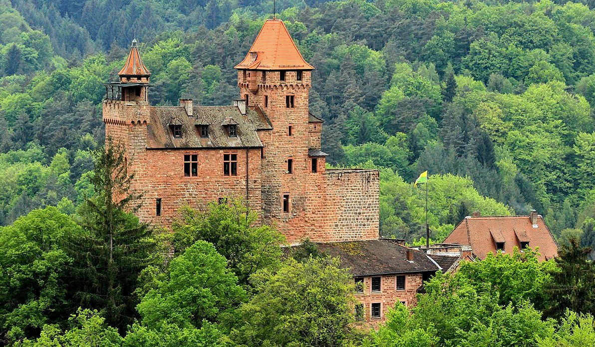
Castles in Germany: within a day's drive of 3 (F) Wing, RCAF Station Zweibrücken, Rheinland-Pfalz
Castles (Burgen und Schlösser) in Germany near Zweibrücken, Rheinland-Pfalz

(Rolohauck Photo)
Aerial view of Trifels, where Richard the Lionheart was held prisoner after the 3rd Crusade.
Most Canadians who lived in Zweibrücken from March 1953 to 27 August 1969, will be familiar with the numerous medieval castles within a short drive of the city. There are many, and the aim of this page is to tell you a bit about them.
My father, Warrant Officer (Retired) Aage C. Skaarup served with the RCAF at 3 (F) Wing, Zweibrücken, Germany, (1959-1963), and he took our family castle hunting often throughout our time there. This generated a huge interest for me in exploring and examining these historic time capsules. When I joined the Army, I had the extraordinary privilege of serving with HQ CFE in Lahr from 1981 to 1983, and with 4 CMBG based at CFB Lahr, from 1989 to 1992.
I often returned to visit the castles I explored with my parents and brother Dale, and have taken my own family to see them as well. I have explored, photographed, painted pictures and documented castles from one end of Europe to the other, and you will find other pages describing some of them on this website, but this page is specifically dedicated to castles within an hour or two's drive from Zweibrücken.
Zweibrücken is a town in the Rhineland-Palatinate, on the Schwarzbach river. The name Zweibrücken means 'two bridges older forms of the name include latin, Geminus Pons and Bipontum, and French Deux-Ponts, all with the same meaning. The town was the capital of the former Imperial State of Palatinate-Zweibrücken owned by the House of Wittelsbach. The ducal castle is now occupied by the high court of the Palatinate (Oberlandesgericht). There is a fine Gothic Protestant church, Alexander's church, founded in 1493 and rebuilt in 1955. From the end of the 12th century, Zweibrücken was the seat of the County of Zweibrücken, the counts being descended from Henry I, youngest son of Simon I, Count of Saarbrücken (d. 1182). The line became extinct on the death of Count Eberhard II (1394), who in 1385 had sold half his territory to the Count Palatine of the Rhine, and held the other half as his feudal domain. Louis (d. 1489), son of Stephen, founded the line of the Counts Palantine of Zweibrücken (Palatinate-Zweibrücken). In 1533, the count palatine converted Palatinate-Zweibrücken to the new Protestant faith. In 1559, a member of the line, Duke Wolfgang, founded the earliest grammar school in the town (Herzog-Wolfgang-Gymnasium, which lasted until 1987. When Charles X Gustav, the son of John Casimir, Count Palatine of Kleeburg, succeeded his cousin, Queen Christina of Sweden, on the Swedish throne, Palatinate-Zweibrücken was in personal union with Sweden, a situation that lasted until 1718.
A the beginning of 1680, Louis XIV's Chambers of Reunion awarded Zweibruecken and other localities to France, but under the 1697 Treaty of Rijswijk, "The Duchy of Zweibruecken was restored to the King of Sweden, as Count Palatine of the Rhine." In 1731, Palatinate-Zweibrücken passed to the Palatinate-Birkenfeld-Zweibrücken branch of the counts palatine, from where it came under the sway of Bavaria in 1799. It was occupied by France in 1793 and on 4 November 1797, Zweibrücken became a canton centre in department of Mont Tonnerre. At the Peace of Lunéville in 1801, the French annexation of Zweibrücken was confirmed; on its reunion with Germany in 1814 the greater part of the territory was given to Bavaria, the remainder to Oldenburg and the Kingdom of Prussia. The town of Zweibrücken became part of the Palatine region of the Kingdom of Bavaria.
The last prominent social event before the First World War was the inauguration of the Rosengarten (rose garden) by Princess Hildegard of Bavaria in June 1914. As a consequence of the First World War, Zweibrücken was occupied by French troops between 1918 and 1930. In the course of the Kristallnacht in 1938, Zweibrücken's synagogue was destroyed. On the outbreak of the Second World War the town was evacuated in 1939-1940, as it lay in the ‘Red Zone’ on the fortified Siegfried Lind. Shortly before the end of the war, on 14 March 1945, the town was nearly completely destroyed in an air raid by the Royal Canadian Air Force (RCAF), with the loss of more than 200 lives. On 20 March 1945, American ground troops reached Zweibrücken. The town became part of the new state of Rhineland-Palatinate after the war. In 1993, the town underwent a major change. With the departure of the Americans, the military area became free, which corresponded altogether to a third of the entire urban area. Unemployment increased to approximately 21%, leading to a decrease in demand in the retail trade of approximately 25%. The Zweibrücken City Museum has a permanent exhibition in the former residence of court gardener Ernst August Bernhard Petri, documenting the eventful history of Zweibrücken. In addition, special exhibitions take place regularly, e.g. on the occasion of the 200th anniversary of the State Stud.
RCAF Station Zweibrücken, also known as 3 Wing or 3 (F) Wing was one of four RCAF wings, consisting of three fighter squadrons each, established in Europe at the beginning of the Cold War. These four wings were part of the RCAF's No. 1 Canadian Air Division (1 CAD), which was formed as part of Canada's air defence commitment to NATO during the Cold War. The RCAF headquarters was located in Metz, France. Other bases were 1 (F) Wing, Marville, France, 2 (F) Wing, Grostenquin, France, and 4 (F) Wing, Baden-Soellingen, West Germany.
.jpg)
Three RCAF squadrons flying Canadair CL-13 Sabre fighters were located at Zweibrücken: Nos. 413, 427 and 434. The three squadrons arrived at Zweibrücken in March 1953. No. 413 Squadron was replaced in 1957 by No. 440 Squadron, flying the then new Avro CF-100 Canuck all-weather interceptor. In 1959 Canada adopted a new and controversial nuclear strike role in accordance with NATO's doctrine of "limited nuclear warfare" and began re-equipping with the new Canadair CF-104 Starfighter, that could handle the delivery of nuclear weapons. This aircraft also had a reconnaissance role.
In the fall of 1962 the Sabre squadrons of 1 CAD, including those at 3 (F) Wing, began flying Starfighters. No. 440 Squadron was disbanded in December 1962. No. 430 Squadron moved to Zweibrücken from Grostenquin when 2 (F) Wing closed down in 1964. The RCAF left Zweibrücken on 27 August 1969 as an austerity measure following unification of the Canadian Armed Forces. Its units consolidated at Canadian Forces Base (CFB) Lahr and CFB Baden-Soellingen. Before leaving, they erected a west coast Indian totem pole as a token of their friendship with the local German citizens. At the top of the pole was the Thunderbird, the First Nations god who watches over all creation. Below it was a double headed sea monster, the warrior's symbol; the third figure was of a little man who had grown from boyhood to become a warrior, and the fourth figure was that of the same warrior, grown to maturity as a tribal chief.
Upon the departure of the RCAF, control of the station was transferred to the United States Air Force (USAF) Sixteenth Air Force, USAF Europe (USAFE. Upon taking control of Zweibrücken Air Base, the United States Air Force either renovated or enlarged all base facilities. With the end of the Cold War, the USAF presence at Zweibrücken was gradually phased out. On 31 July 1991, Zweibrücken Air Base was closed. The facility was turned over to the German government civil authorities. The former Zweibrücken Air Base has been transformed into the modern Zweibrücken international airport.
Canadians who were posted to Europe after the closure of some of bases in France and Germany, became part of Canadian Forces Europe (CFE). CFE consisted of two formations in what was then known as West Germany, before the Berlin Wall fell in November 1990. These formations included Canadian Forces Base (CFB) Lahr with 4 Canadian Mechanized Brigade Group (4 CMBG) (1957-1993), and No. 1 Canadian Air Division (1 CAD), RCAF, at CFB Base Baden-Soellingen and CFB Base Lahr. 1 CAD later became No. 1 Canadian Air Group (1 CAG). Both formations were closed in 1993 with the end of the Cold War.
Note: Castles and Châteaus in France within an hour or two of Zweibrücken are listed on a separate page on this web site. For those with an enthusiasm for castle hunting and in particular, those around Zweibrücken, I hope you find this web site interesting.
Harold sends

(Thomas W. Jefferson Photo)
Schloss Zweibrücken (Residenzschloss) is a building in the town of Zweibrücken, Rheinland-Pfalz, Germany.
It was built as a ducal palace in 1720-1725. It is the largest and most magnificent secular (i.e. non-religious) building in the Palatinate (Pfalz). It is now the seat of the Palatine Higher Regional Court (Pfälzisches Oberlandesgericht), and of the Zweibrücken law courts (Generalstaatsanwaltschaft). The earliest recorded building near the site was a fortress (Burg Zweibrücken). It was built in the 12th century by the Counts (Grafe) of Zweibrücken, because the town was on an important trade route. It sat on the eastern side of an open triangular area, which still exists today, known as the Schlossplatz (Castle place).
In 1444, a junior (cadet) branch of the House of Wittelsbach was granted the title of Duke (Herzog) of a new state: Palatine Zweibrücken (Pfalz-Zweibrücken), with its seat in Zweibrücken. In the 16th and 17th centuries, the ducal family modernised and enlarged their dwelling-place. In 1585, they constructed a palace (known as "the long building by the water", der lange Bau am Wasser) on the northern side of the Schlossplatz, complete with water-mill and library. In 1677, the ancient and the newer buildings were badly damaged during the Franco-Dutch War (1672–1678).
In the early 18th century, Gustav, Duke of Zweibrücken ordered the construction of a new residence appropriate for his rank and status. The architect was Jonas Erikson Sundahl, whose design was in the modern Late Baroque style - for show and comfort, and not for defence. In 1720–25, this palace was built on the northern side of the
Schlossplatz. The site was marshy, so preliminary work involved driving very many oak piles into the ground to provide a solid foundation. That building has been twice destroyed and twice rebuilt; its second reconstruction is the building which exists today. Christian IV, Duke of Zweibrücken 1735–1775, entertained notable creative artists at his palace, including the leading operatic composer Christoph Willibald von Gluck. Christian's nephew Maximilian (1756–1825) spent some of his childhood at the palace. On 3 May 1793, during the War of the First Coalition, Zweibrücken was overrun and sacked by French troops. The building was badly damaged.
In 1817, Maximilian, in 1795–99 Duke of Zweibrücken, now King Maximilian I of Bavaria, gave the ruined building to the Catholic community of the town, with the command to convert it into a church. The central part of the building was walled off from its wings, and was roofed with slate. On 28 May 1820, it was consecrated as the Maximilianskirche by Johann Jakob Humann, Vicar Apostolic of both Speyer and Mainz. A bell tower was added later. The east wing was turned into a residence for the clergy. The west wing became a royal residence, and later the seat of the Royal Court of Appeals of the Palatinate. In 1867, the Maximilianskirche was deconsecrated and the whole building turned over to the administration of justice. The bell tower was taken down.
On 14 March 1945, in the final stages of the Second World War, Zweibrücken was the target of an Allied bombing raid. The building was gutted, and only its outer walls left standing. By great good fortune, a copy of Sundahl's original plans was discovered in Nancy, France. Between 1962-1964, the building was rebuilt from those plans, using red sandstone from the northern Palatinate and yellow sandstone from Lorraine. In 1965, the restored building was returned into use as the seat of the Palatine Higher Regional Court and of the Zweibrücken law courts. (Ammerich, Hans, Zweibrücken. Die alte Herzogsstadt in Geschichte und Gegenwart, Zweibrücken 1983)

(Aage Skaarup Photo)
This is my Mother Beatrice, my brother Dale and I, and our first view of Schloss Zweibrücken in July 1959.

(Immanuel Giel Photo)
Schloss Zweibrücken.
Fortresses and Castles have been built in the area over a long period of time.
Römermuseum Schwarzenacker (Schwarzenacker Roman Museum) is an archaeological open-air museum in Schwarzenacker, a district of Homburg, Saarland, Germany, just a few km NW of Zweibrücken. The museum was constructed by archaeologist Alfonso Kolling, who also led the archaeological excavations at the site. The current director is Klaus Kell. The Museum shows the remains of a Roman vicus (country town) of approximately 2000 inhabitants which existed from the time of the birth of Christ until its destruction by the Alemanni in 275 A.D. Visitors can view the excavated buildings, grounds, roads and culverts.
In the adjoining 18th century villa and the reconstructed houses of the vicus, important finds from the everyday life of the Roman population are exhibited, found either at the settlement itself or in the surrounding area. At the front steps of the villa stand life-size replicas of Roman equestrian statues which were discovered in 1887 in nearby Breitfurt. The originals stood for many years at the entrance of the Historical Museum of the Palatinate in Speyer, but they were removed and placed in the courtyard of the museum under a canopy, since they were heavily weathered due to environmental factors. The villa has a landscaped garden in the Baroque style, which was created following the excavation of the vicus.
Castles
There are quite a few castles in the Rhineland-Palatinate within an hour or two's drive from Zweibrücken. Although many are in ruins, a few have been restored and some of them have a history that extends back more than 1000 years. Many have been the setting of historical events and the domains of famous personalities; and often remain imposing edifices to this day. These are a few that you may have visited if you were a family member based at RCAF Station Zweibrücken. This list includes buildings described on German as a Burg (castle), Festung (fort or fortress), Schloss (manor house, palace or hunting lodge) and Palais/Palast (palace). After the Middle Ages, many German castles were built as, or converted to, royal or ducal palaces rather than fortified buildings.

(Luger Photo)
Drachenfels Castle is a ruin near the village of Busenberg in the state of Rhineland-Palatinate. It lies within the German half of the Wasgau region, in the southern part of the Palatine Forest. Drachenfels (Dragon's Rock) Castle is about 7 kilometres (4 mi) north of the Franco-German border on the eponymous 150-metre-long bunter sandstone rocks which are on a ridge at an elevation of 368 metres (1,207 ft) above sea level. The highest part of the rocks was turned into a keep or bergfried. Because of its present appearances the remains of the tower are known as the Backenzahn ("molar tooth") by the locals and make it one of the most striking castles in the Rhineland-Palatinate.
Not far from the Drachenfels are several other historic castles: just 3 kilometres (2 mi) to the south-east is Berwartstein; a similar distance to the north-west are the three castles of Dahn; Lindelbrunn is 6 kilometres (4 mi) northeast and the group of castles on the Franco-German border - the Wegelnburg (German) and the Hohnebourg, Lœwenstein, and Fleckenstein (all on the French side) - are 10 kilometres (6 mi) to the southwest. Man-made chambers have been hewn out of a rock massif opposite the castle, the so-called Buchkammerfels, which lies on the Heidenberg, 420 metres (1,380 ft) high. The date and function of these Heidenkammern are unknown: it is speculated it may have been an outpost of the Drachenfels. The name of the castle could have come from the dragon carved in the sandstone wall of the old great hall of the castle. However, because it has not been dated, it is also possible that the dragon was inscribed on the wall because of the castle's name.
The origins of the castle are largely unclear. Archaeological finds here can be dated to the mid-13th century, but the castle was already in existence in the early 12th century. In 1209 the brothers Conrad and William of Drachenfels were first mentioned in the records. Historian, Johann Lehmann (1797–1876), named a Burkhard of Drachenfels between 1219 and 1221 who was in service for the House of Hohenstaufen, but he gave no references. Other documents confirm that, in 1288, a dispute was settled between the cousins Rudolph and Anselm of Drachenfels on the one hand and the Bishop of Worms on the other. The oldest surviving seal of these two cousins depicts a dragon in a pointed shield (Spitzschild). From the early 14th century the seal contained a deer's skull or a wild goose. The first lesser nobleman who it is known with any certainty that had a connection with this castle in the Wasgau is Walter of Drachenfels (also Waltherus de Drachenvels) in 1245.
In 1314 the lords of Drachenfels were promised compensation payments for a campaign by the city of Strasbourg against Berwartstein Castle, during which the nearby castle at Drachenfels was also besieged and damages. In 1335 there was a conflict with Strasbourg in which the lords of Drachensfels were accused of being robber barons. At this time Drachenfels was besieged and partially destroyed, forcing its lords to gradually sell off parts of the castle from 1344. As a result, Drachenfels became a jointly-owned castle or Ganerbenburg, whereby several families or individuals divided the estate between themselves.
In 1510 the rebellious imperial knight, Francis of Sickingen, also bought a share in the castle. On 10 May 1523, after his defeat by the allied armies of three imperial princes, the castle was finally destroyed, although the Burgvogt, who occupied it with just eight servants, had surrendered without a fight owing to the odds that he was faced with. The victors refused to allow the castle to be rebuilt. What was left of the castle after it had been slighted was used as a quarry. In 1778, a descendant of its owners, Freiherr Franz Christoph Eckbrecht von Dürkheim, built a manor house in the village of Busenberg with the stones from Drachenfels, which is known today as the Schlösschen ("little palace"). The church in Busenberg was also built from stones from the ruined castle.
The moderate remains of the castle in the eastern part of the site are dominated by the so-called Backenzahn, the castle rock in the east. On the rock only a few original wall courses have survived. All the same, a climb up the steps partially carved into the rock conveys an idea of the strength of the fortification. On the plateau of the former bergfried are the remains of a cistern. In the rooms hewn out of the rock, putlock holes and other manmade marks chiselled into the sandstone indicated that it was once entirely covered by timber-framed or stone buildings.
Considerably more has survived of the lower ward and gate system. In 1903, the gate tower was enhanced by two round-arched portals. Since 1990, the remains of two other towers, a small outer bailey, as well as walls and buildings have been the focus of conservation and excavation activities by the "Directorate General for Cultural Heritage in Rhineland-Palatinate".
The visitor first enters the tower, which admittedly was added later, but is made throughout of rusticated ashlars with lifting holes on which numerous stone marks can be seen. Access to the upper ward was achieved through an older tower built against the rock. Today there is a staircase between the two gate towers, originally there was probably an equestrian staircase here. In the courtyard of the lower ward, two outbuildings have partly survived.
At the basement entrance of the western building, the year 1515 can be seen. In the basement of the other building is the castle well, now filled in. In the castle's later years the somewhat lower western rock was built on. The reason for such extensions is usually a change in ownership of castles, such as conversion of the original fief into a joint inheritance or Ganerbenschaft. However, no walls can be seen on the western rock, and it is not accessible. Elements of the ascent and a guardroom on the south side of the rock have survived.
The site on the western rock had a separate, small, lower ward and its own gate system southeast of the castle rock, of which the remains of a flanking tower with embrasures has survived. In building the castle on the western rock, a multi-story building was built over the old moat. Of this, only the putlock holes have survived, several of which pierce the old image of a dragon carved into the rock. To the north the courtyard was enclosed by a semicircular wall. (Johann Georg Lehmann: Urkundliche Geschichte der Burgen und Bergschlösser der bayrischen Pfalz. 5 vols., 1857–66; reprint by Urausgabe Kaiserslautern, Pirmasens, 1969)

(Franz Photo)
Burg Drachenfels.

(Tara2 Photo)
Burg Drachenfels.

(Hasselburg-muller Photo)
Burg Drachenfels.

(Rudiger Photo)
Burg Drachenfels.

Drawing of Burg Drachenfels, as it may have appeared before its destruction.

(Ulli1105 Photo)
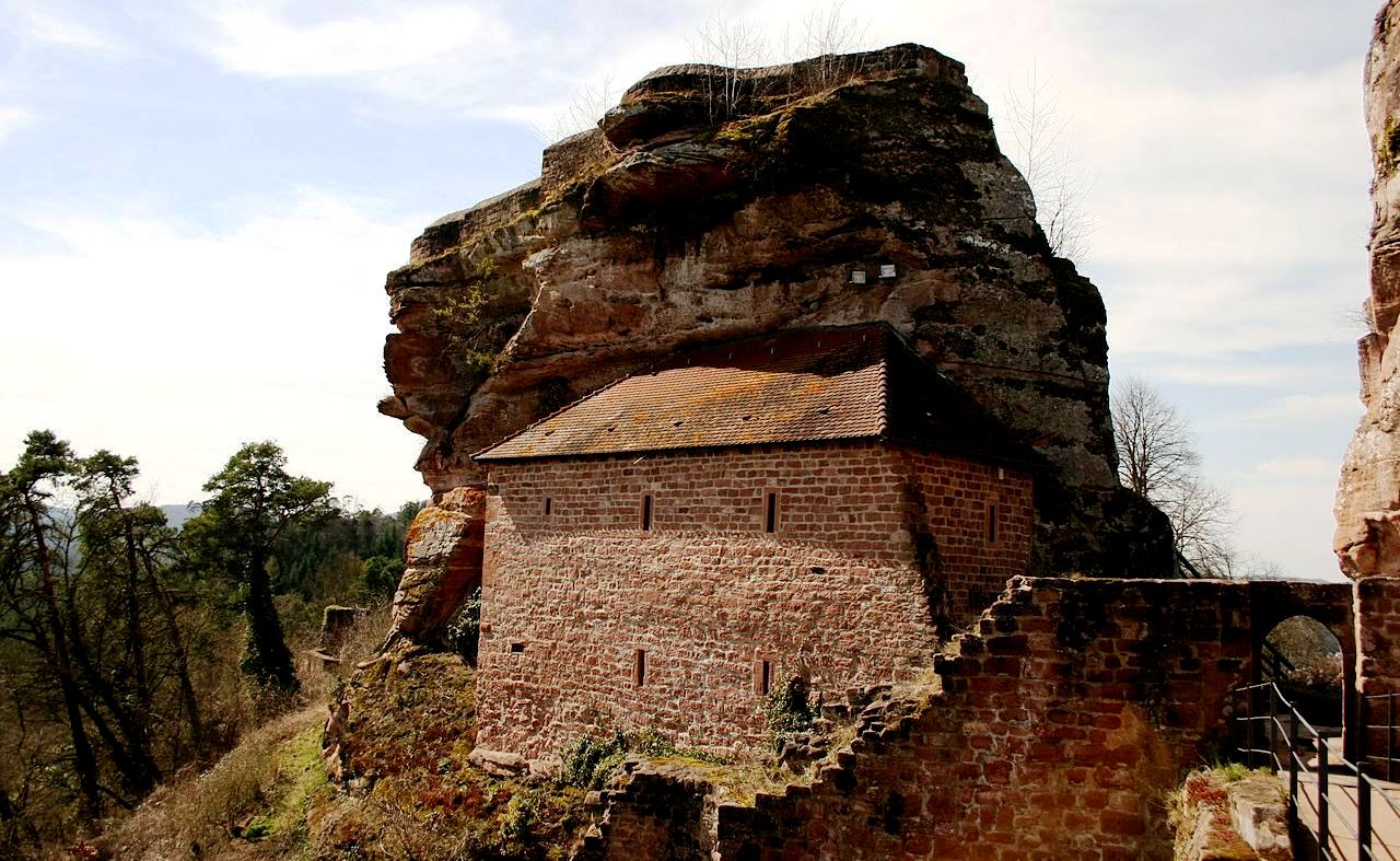
Berwartstein Castle (Burg Berwartstein) is a castle in the Wasgau, the southern part of the Palatinate Forest in the Rhineland-Palatinate state in southwestern Germany. It was one of the rock castles that were part of the defences of the Palatinate during the Middle Ages. In the publication Works of Preservation of Monuments of Rheinland-Pfalz, which was assembled and edited for the Ministry of Education and Culture, is is listed as one of the three prime examples of rock castles in the region, which include the Frachenfels, Altdahn and Berwartstein. These are castles where the stairs, passages and rooms are carved out of the living rock to form part of the accommodation essential to the defence of the castle. Although the Berwartstein appears more complete when compared to the ruins of neighbouring castles, it is only a restoration of the original rock castle. It is the only castle in the Palatinate that was rebuilt and re-inhabited after its demolition.
There is no definite record of the origins of the castle or its name. The name "Berwartstein Castle" is mentioned for the first time in a document dating from 1152, when the castle was granted by Emperor Frederick Barbarossa to Bishop Günther of Speyer. During the 13th century, feudal tenants, who carried the name "von Berwartstein" inhabited the castle, which they used as a base for raids in the manner of robber barons. The imperial cities of Strasbourg and Hagenau joined forces against the von Berwartsteins. Following several weeks of futile attacks against the castle, they succeeded in taking it in 1314, with the help of a traitor. A large amount of booty and about 30 prisoners were taken to Strasbourg. The knights of Berwartstein were permitted to buy the prisoners back for a large ransom. The knights of Berwartstein were forced to sell their castle to the brothers Ort and Ulrich von Weingarten. Four years later the castle became the property of Weissenburg Abbey.
The monastery at Weissenburg placed the castle in stewardship and established a feudal system. This allowed for the dismissal of vassals who became too presumptuous. Thus the monastery held possession of the castle for some time. This could have continued indefinitely had the last steward of the castle (Erhard Wyler) not gone too far. When he began feuding with the knights of Drachenfels, the Elector of the Palatinate took the opportunity to bring the Berwartstein Castle under his control. Because of his dynastic ambitions, the Elector of the Palatinate wanted to bring all of the Weissenburg estate under his control. To accomplish this, in 1480 he ordered the knight, Hans von Trotha, who was Marshal and Commander in Chief of the Palatinate forces, to acquire to Berwartstein. In this way he could enlarge the property at a cost to the Monastery of Weissenburg. For the quarrelsome knight this was a pleasure to fulfil, since this gave him a chance to take personal revenge on the Abbot of Weissenburg. Years before, Abbot Heinrich von Homburg had imposed a church fine on his brother, Bishop Thilo.
As a starting point for this conquering expedition, this experienced warrior first renovated the castle to improve its appearance. He built strong ramparts and bastions as well as the outwork and tower called Little France. After von Trotha's death, Berwartstein Castle was inherited by his son Christoph and, when he died, it went to his son-in-law, Friedrich von Fleckenstein and remained in the hands of this family for three generations. During this time, the castle was destroyed by fire in 1591, and, since there is no mention of any attacks, it is presumed that the castle was hit by lightning. Even though the main sections of the castle were not destroyed by the fire, it stood empty and unused for many years. In the Peace of Westphalia (1648), Berwartstein received special mention, when it was granted to Baron Gerhard von Waldenburg, known as Schenkern, a favorite of Emperor Ferdinand III. Since he did not restore the castle, it fell into ruins.
A certain Captain Bagienski purchased the castle in 1893. In 1922, it was sold to Aksel Faber of Copenhagen, and thus went into foreign ownership. Since he was seldom in Germany, he asked Alfons Wadlé to be his steward. Later on, Wadlé was able to purchase the castle. The village of Erlenbach below the castle was completely destroyed during the Second World War, and its inhabitants sought shelter in the castle. After the war, the roof had gone as well as the woodwork around windows, doors, staircases and other furnishings. Since the castle was not financially supported, Alfons Wadlé went about the renovation himself. At first he was only able to do what was essential to protect the castle from the elements.
Berwartstein has an opening on the southeast side of the cliff, commonly referred to as Aufstiegskamin (entrance chimney). During the early years of the castle only the rooms and casemates in the upper cliff were complete and the shaft was the only entrance to the castle. To make it easier to ascend the shaft, a portable wooden staircase or rope ladder was placed into the castle. In the event of attack, the staircase or ladder was hoisted up into the castle. This enabled the entrance to be defended by just one man who was supplied with boiling sap, oil or liquid to pour on any intruder attempting to ascend the shaft. This limited access to the castles inner rooms was probably the main reason it was never conquered during the Middle Ages. The narrow, almost vertical cliff on which the castle stands, rises to a height of approximately 45 metres.
The extremely deep well is one of the castle builders' greatest accomplishments. The well has a diameter of 2 metres (6 ft) and was hacked out of the rock to the bottom of the valley some 104 metres below. This was essential to the castle's survival when under siege. The historic Great Hall or Rittersaal has a cross-vaulted ceiling. An engraving on the supporting central pillar shows that it dates to the 13th century. The south wall of the hall is made from rock and includes a hewn-out lift shaft used by the knights of Berwartstein to deliver supplies to the table and deliver food and drink from the kitchen above.
Carved out of the cliff and accessible even today are corridors and passageways which used to be part of the large underground defence network. Although not accessible today, there was once a tunnel from the castle to the village below. These tunnels were hewn out with hammer and chisel and partly dug through the soil. To the south on the opposite side of the valley from the castle on a spur of the Nestelberg can still be seen the tower of Little France. This tower was part of an outwork or small subsidiary castle built by the well known knight and castellan of the Berwartstein, Hans von Trotha. The tower was an important observation post and defensive position, and meant that any attackers would have found themselves caught in a crossfire between the tower and the castle. The open ground in the valley below between the tower and castle still bears the name Leichenfeld (Corpse Field), a reference to the battles fought there. There is also evidence of an underground passage between the tower and castle which is no longer accessible today since it has largely collapsed.

(H. Zell Photo)
Berwartstein, view from the southeast.

(Klaus Ableiter Photo)
Berwartstein, underground passageways cut through the living rock.

(Franzfoto Photo)
Berwartstein, armour and stone catapult balls.

(Ulli105 Photo)
Berwartstein, Little France tower.

(BlueBreezeWiki Photo)
Berwartstein.

Drawing of Berwartstein, before its destruction and modern rework.
(Pascal Dihé Photo)
Berwartstein.

(Giulia Samira Photo)
Berwartstein.

(Lockileck Photo)
Berwartstein bergfried.

(H. Zell Photo)
Burg Berwartstein well, 10 metres deep. Burg Berwartstein) was one of the most interesting castles that I have a clear memory of my parents taking us to visit on 27 March 1960. The guide poured a cup of water into the well and it seemed to take a VERY long time before we heard the splash. He told us that the workers who dug the well could only work in it for a short time, because they would run out of breathable air quite quickly during the work and had to be pulled up so others could take a turn.

(CB Photo)
Casemate II, as it appeared when we came out of the tunnel - quite the introduction to castle tunnel spelunking! This room has been carved out of the living rock, leaving a support section from the original stone which has been cut around. I remember my father explaining that the robber knights operating from this castle created a problem for the rulers in the area, so they commissioned one of their best knights to go and sort them out. He managed to get the best of them, but on reflection decided they had a pretty good scheme going, and so he joined them, taking over the business, so to speak. Even more remarkable, the fortress was so well defended, the Robber Knight died of old age, quite rare for the profession. This castle is typical of many I have explored during our time in Germany.

(H. Zell Photo)
Burg Berwartstein, showing the original stone entrance, accessible only by a ladder lowered from the defenders above.

(Rudiger Photo)
Altdahn Castle (Burg Altdahn) is a castle ruin in the Palatinate Forest, the German part of the Wasgau region, and is located near the town of Dahn in the Rhineland-Palatinate. It stands 337 metres (1,106 ft) above sea level. The rock castle of Altdahn belongs to the group of castles at Dahn, which also includes Grafendahn and Tanstein. Although the three castles are sited next to one another on a low, rocky ridge, they were not built at the same time. A similar type of castle arrangement is also found e. g. in the nearby French Vosges in the upper Alsace, where there is a cluster of three castles at Husseren-les-ChVteaux. Other sights nearby include the castle of Neudahn and the natural rock formation of Jungfernsprung.
Altdahn was probably built in the early 13th century. Certainly in 1236 the castle was being run by Frederick of Dahn as a vassal (Lehnsmann) of the Bishop of Speyer who, at that time, was Conrad IV of Dahn, and may well have been a relative. The subsequent history of the castle is characterized by many wars and frequent destruction, that was, time and again, followed by rebuilding. Altdahn was first destroyed in 1363 in the course of a feud between the Dahns and the Fleckensteins. In the end, a squire took possession of the castle and carried out temporary repairs. In 1372 it was destroyed again and the squire was driven out. In 1406 the castle was destroyed in the War of the Four Lords, which played out from 1405 to 1408 especially in the Bliesgau, 40 kilometres to the west. In 1426 and 1438 the castle caught fire although this was not caused by military action.
After two centuries of relative prosperity Altdahn suffered further damage during the Thirty Years' War (1618–1648). At the beginning of the War of Palatine Succession, the castle was finally destroyed in 1689 by French troops under General Mélac. On 11 May 1820, a rockfall occurred, that caused the majority of the remaining ruins to collapse. Mendolssohn, the composer and artist, visited the ruins on 5 August 1844 in order to paint them. The originals are in Oxford, but copies may be seen in the museum, as can a medieval silver spoon engraved with the coat of arms of the lords of Dahn.
On the ridge of the Dahn castle group, which run roughly from east-northeast to west-southwest, Altdahn Castle occupies the two largest, easternmost rock outcrops, which have a total length of about 100 metres (330 ft). Its access is in the northeast, where the gateway and a small, water-filled neck ditch have survived. The lower ward is dominated on the north side by a horseshoe-shaped turret (Geschützturm) and, on the south side, by another tower of similar design. Other notable remains of the upper ward on the western rock outcrop that have survived, include the north wall of the palas and a watchtower that, from the remains of an oriel, indicate that it may well have been used as a garderobe tower. The southern part of the palas was destroyed in the rockslide of 1820. This also opened the remains of a round cavern, in the rock in the shape of an inverted cone, that has been identified as a cistern or dungeon. On the remains of the eastern side, rusticated ashlar stonework is visible. The isolated eastern castle rock is accessible over a narrow gangway. It used to support a small tower. In 1877 the first conservation work was carried out by the Dahn Conservation Society (Dahner Verschönerungsverein) under the Bavarian government. In 1936, restoration work was restarted. After an interruption caused by the Second World War the work continued from 1960 to the present day. In 2007, cracks were confirmed on a 1,100 ton block of sandstone on the castle. If this were to break, a third of the castle would be destroyed. Geologists placed sensors against the rock in order to observe further changes. Using abutmentss on the ground, the rock was secured, but these measures were very expensive and time-consuming. The all clear was given in June 2008, because the sensors did not pick up any further movement of the rock. The electronic sensors were removed and replaced with manually readable "rock spies" (Felsspione). The rock will be closely watched for the next few years. (Marco Bollheimer (2011), Felsenburgen im Burgenparadies Wasgau-Nordvogesen (in German) (3rd ed.), Karlsruhe: Selbstverlag)

(Peter Schmenger Photo)
Altdahn south tower.

(Peter Schmenger Photo)
View from Tanstein over the second rock from Tanstein via Grafendahn to Altdahn.

(Haselberg-muller Photo)
Burg Altdahn, View of the remaining north wall of the hall and tower.

(Peter Schmenger Photo)
Altdahn, ascent to the keep.Grafendahn, in the background Tanstein, view from Altdahn keep.

(Peter Schmenger Photo)
Altdahn, ascent to the keep.

(Haselberg-muller Photo)
Grafendahn Castle (foreground) and Tanstein (back) from the tower of Altdahn Castle.
(Haselberg-muller Photo)Castle rock of Grafendahn Castle from the east, the castle museum in the foreground.

(Haselberg-muller Photo)Burg Tanstein, view from the south, location Unterburg.

(Carola Neuchel Photo)
Altdahn, Grafendahn and Tanstein near Dahn in the Palatinate Forest. The entrance to the northern battery tower of the castle.

(Franzfoto Photo)
Aldahn ruins.

(Schrodian Photo)
Altdahn castle ruins near Dahn in the Palatinate Forest Nature Park, Südwestpfalz district, Rhineland-Palatinate.

(Tino E Photo)
View from the keep of Altdahn castle over the former hall to the east.

(Carola Neuchel Photo)
Burg Neudahn is a rock castle in the southwestern Palatine Forest in the German state of Rhineland-palatinate. It is located at the northern end of an elongated ridge near the town of Dahn. The heart of the castle is situated on one of the sandstone rock outcrops that are typical of the Dahner Felsenland region. Neudahn lies 2 kilometres northwest of Dahn, right of the River Lauter, which is known here in its upper reaches as the Wieslauter. The castle stands atop the Kauertberg hill, about 90 metres above the valley floor. The main castle rock is 310 metres above sea level, that of the lower ward reaches 290 metres. Immediately below the castle the Moosbach stream, which is impounded in a small woog (local name for a body of still water), used to feed an old mill, empties into the Wieslauter.
The name "Neudahn" ("New Dahn") is rather confusing, because the castle is older than Grafendahn Castle in the nearby group of three castles of Dahn, albeit more recent than Altdahn (Old Dahn). Its location enabled it to protect and block the old road running through the Wieslauter valley, the course of which is now used by the B 427 federal highway and the Wieslauter Railway. The castle was probably built just before 1240 by order of the Bishop of Speyer, because from 1233 to 1236 the office was held by Conrad IV of Dahn. The governing ministerialis was Henry of Dahn, who is also recorded as Henry Mursel of Kropsberg. He was probably granted the castle from the outset as a heritable fief. His second name, like other later heirs, indicates clearly that there were family ties with the South Palatinate-Kropsburg and Burrweiler. The castles is first mentioned on 3 May 1285 as Burg Than, an assessment of the estate mentioned in the deed indicating that it must refer to Neudahn.
Within a hundred years of the castle being built, the Mursel family died out, and its possession passed to the related Altdahn line. Probably razed during the Four Lords' War of 1438 and then rebuilt, the site was again badly damaged during the German Peasants' War in 1525. Because, King Henry II of France stayed overnight at the castle in 1552, it must have been thoroughly renovated before then. After the last lord of Dahn, Ludwig II died in 1603 in his castle at Burrweiler, Neudahn was returned to the Prince-Bishopric of Speyer. From then on the castle was used by the episcopal Amtmann as his headquarters until French troops finally destroyed it in 1689 at the start of the War of the Palatine Succession.
Today the castle appears to visitors largely as it did in the renovation and extension phase in the period after 1525 and after the last destruction. Safety and restoration measures took place in the 1970s. The site is managed by the Generaldirektion Kulturelles Erbe Rheinland-Pfalz, Direktion Burgen, Schlösser, Altertümer, and, together with Berwartstein Castle, 10 kilometres away, is one of the best preserved castles in the southern Palatine Forest. Left of the place where the original gates were located, in the southeast, are the remains of a tower, 7 metres in diameter. From this tower, parts of a thick defensive wall runs westwards, before bending north. On the steep northern and northeastern side of the hillside the wall has entirely disappeared. It led to the flanking tower at the northern end of the site.
Of the oldest parts of this late Hohenstaufen castle, built on the vertically hewn, central rock outcrop, which is just under 20 metres high, the only surviving features are a cistern at the western end and the southern wall of the small palas with its window and door openings. At the northwestern end of the main rock outcrop in the south was a late medieval domestic building and, west of that, a well. A formerly plastered newel tower from the same period on the northwestern edge of the rock outcrop leads up to the upper ward. The actual entrance into the ground floor is, as on many castles, probably not authentic and may have been made for modern visitors, which the date 1975 over the entrance suggests. It also lies outside the inner gate. The historic entrance is inside the gate to the left and at a higher level.
The dominant image of the castle is the two four-story, roughly 24 metre-high, battery towers on the opposite side. They date to the first half of the 16th century. The west tower measures about 7 metres in height, the east tower, about 10 metres. The thickness of the walls is about 3 metres. Two embrasures (so-called Maulscharten) on the southern battery tower have been ornately carved into the shape of lions' faces. On the continuation of the hill to the east-southeast the site was protected by a wedge-shaped bastion that was also a recognition feature of Neudahn. Its shape was intended to prevent shells from striking the castle frontally. It protected the upper ward on the more gentle slope of the hill on that side. The bastion and the weapon towers show that, in the late Middle Ages, considerable modifications to the castle were carried out and the lords of the castle took account of the introduction of firearms and cannon. (Marco Bollheimer (2011), Felsenburgen im Burgenparadies Wasgau–Nordvogesen (in German) (3rd ed.), Karlsruhe: Selbstverlag)

(Hassellurg-Muller Photo)
Burg Neudahn, interior of the mezzanine, restored condition. On the right two round stairs that lead up (front) and down (back).

Ground plan of Burg Neudahn.

(ich selbst Photo)
Burg Neudahn.

(Hassellurg-Muller Photo)
Burg Neudahn.

(Franzfoto Photo)
Burg Neudahn.

(Dietrich Krieger Photo)
Burg Neudahn, embrasure in form of a mouth.

(Steffen 962 Photo)
Burg Neudahn, embrasure in form of a mouth.

(derivative work Photo)
Burg Neudahn, view from the south.

(BlueBreezeWiki Photo)
The Rietburg is a ruined hillside castle on the edge of the Palatinate Forest above the village of Rhodt in the county of Südliche Weinstraße in the German state of Rhineland-Palatinate. The remains of the Rietburg stand at a height of 535 metres above sea level on the northeastern flanks of the 618-metre-highhigh Blättersberg mountain,a peak in the Haardt mountains that form the eastern edge of the Palatinate Forest. All that has survived of the castle is part of the shield wall, parts of the enceinte and the zwinger (an area between two defensive walls sued as a kill zone).
The construction of Rietburg castle is dated to the period 1200 to 1204 and ascribed to the Lords of Riet. These noblemen were initially vassals of the North Alsation Benedictine abbey of Weißenburg, later they became ministeriales and feudatories of the then German Hohenstaufen lords. The family came from the region between Speyer and Germersheim, and had taken their name from their place of origin along the Rhine River that had been colonised by reeds (Riet). They were first mentioned in 1149 in a deed belonging to the South Palatine abbey of Eußerthal. The castle was built by Conrad II of Riet, the eldest of six sons of Conrad I and his wife, Adelheid, whom he married in 1184. Following the death of Conrad II, his cousin, Hermann of Riet, inherited the lordship of the castle (Burgherrschaft). In the conflicts that broke out after 1250 between the Hohenstaufens and the Welfs, he remained a Hohenstaufen follower and went down in history as the result of a political hostage taking: in 1255 he took the Welf Queen Elisabeth, wife of the German King William, hostage, together with her escort during a journey from the episcopal town of Worms to the imperial castle of Trifels near the village of Edesheim. She was imprisoned at the Rietburg. A coalition of regional princes and towns forced him to release his prisoners on 4 December 1255. Hermann escaped with his life, but his castle was seized from him and declared an imperial castle that was under the immediate suzerainty of the king. Its first vassal was the Upper Alsatian Landvogt, Otto III of Ochsenstein. When his daughter married Emich V of Leiningen-Landeck in the 1280s, the castle went to a branch of the House of Leiningen. Later, ownership passed to the Bishopric of Speyer.
In 1470, during the Weißenburg Feud between Prince-Elector Frederick the Victorious of the Palatinate and his cousin, Duke Louis the Black of Palatinate-Zweibrücken, the Rietburg was shelled by Leiningen troops and badly damaged, but remained inhabitable. The castle survived the Palatine Peasants' War of 1525 unscathed, but was finally destroyed during the Thirty Years' War (1618–1648) and never rebuilt. During excavations in 1872, 580 gold and silver coins were found, dating to the 16th century. In 1925 the municipality of Rhodt carried out comprehensive preservation work in order to prevent the further ruin of the Rietburg. In 1931 the Palatine Forest Club built a refuge hut in the castle and, in 1955, the castle restaurant was built. Since 1991 the Rietburg Club has worked on the conservation of the site. In 2012 a wooden bridge was built over the historic neck ditch, which was probably originally spanned by a drawbridge. (Alexander Thon; Stefan Ulrich (2009), Rhodt unter Rietburg – Burgruine Rietburg : Schnell-Kunstführer Nr. 2739 (in German), Regensburg: Verlag Schnell und Steiner)

Ground plan of the Rietburg.

Andreas Rockstein drawing of the Rietburg as it may have appeared before it fell into ruin.

(Palatinatian Photo)
The ruin of Madenburg Castle is one of the biggest and oldest castle complexes in the Rhineland-Palatinate. The castle was built on a cliff on the outskirts of the Palatinate Forest looking towards the Rhine rift valley. The ruin, which is surrounded by forest, lies at an elevation of 458 metres overlooking Eschbach. Despite its strong defences, the castle was destroyed during the War of the Grand Alliance by the troops of Joseph de Montclair. The castle was never rebuilt.

Drawing of Madenburg Castle as it may have appeared before its destruction, by Andreas Rockstein.

Ground plan of Madenburg Castle drawn by Andreas Rockstein.

(Palatinatian Photo)
Aerial view of Madenburg Castle.

(Rollohauck Photo)
Aerial view of Madenburg Castle.

(Martin Dürrschnabel Photo)
Madenburg Castle.

(Ritter Ellen Photo)
Madenburg Castle, entrance.

(Ritter Ellen Photo)
Madenburg Castle.

(Ritter Ellen Photo)
Madenburg Castle.

(Steffen 962 Photo)
Madenburg Castle.

(BlueBreezeWiki Photo)
Landeck Castle (Burg Landeck) is a ruined hill castle southwest of Landau, near Klingenmünster in the county of Südliche Weinstraße in the German state of Rhineland-palatinate, west of the village above the Klingbachtal. Burg Landeck was founded at the end of the 12th century, destroyed in 1689, reconditioned c1910 and 1964–1967. It has a roughly oval outer ring wall with chemise (with inner castle gate), and a donjon built with rusticated ashlar. It has an enceinte built with simple ashlar. In 1416 it was reinforced by a zwinger, and there are remains of a drawbridge still visible.
As with the overwhelming majority of the Palatinate castles, the exact year of foundation is also unknown for Burg Landeck. It is generally assumed that the castle was built as the successor to the nearby tower castle Walastede (now called Schlössel), which was probably destroyed in the second half of the 12th century. There is just as little direct evidence for this assumption as there is for the further thesis that both castles had a protective function for the nearby Klingen (-münster) monastery. The visible architectural features of Landeck refer to the time around 1200. Landeck was actually mentioned and thus definitely documented only in 1237 on the occasion of the division of the Leiningen estates between Count Friedrich III. and Emich IV. von Leiningen. In this division, the castle and all accessories fell to Emich IV, who founded his own line from Leiningen-Landeck.
By the middle of the 13th century at the latest, the complex was an imperial fiefdom, which was jointly owned by the Counts of Zweibrücken and the Counts of Leiningen. In 1255 Emich IV. Intercepted messengers from Mainz and Worms who were moving to Alsace to a city conference at Hördt and deported them to Landeck.
After the rapid extinction of the Leiningen-Landeck sideline in 1289/90, King Rudolf von Habsburg awarded the relapsed half of the imperial castle to his nephew, the Alsatian bailiff Otto III von Ochsenstein, while the other half remained in the possession of the Counts of Zweibrücken-Bitsch.
Only since the beginning of the 14th century can more or less justified, but in the long term successful, attempts by the Abbey of Klingenmünster to pass Landeck and surrounding goods off as their property, which primarily had an impact on the Ochsenstein part. Also important were the ambitions of the Count Palatine near Rhine,
recognizable since the middle of the century, to bring the castle into their hands, which began in 1358/66 with the acquisition of the opening rights. In a similar way due to disputes within the family, disputes among the commoners and not least due to financial difficulties, in 1405 a further share fell to the Principality of Speyer.
The preserved written sources, including the truce, which is particularly important, testify to the attempts of the now three owner parties - the Counts of Zweibrücken-Bitsch, the Lords of Ochsenstein and the Duchy of Speyer - to regulate their castle community sustainably.
Although Landeck had been expanded at the end of the 15th century, the farmers of the Alsatian piston heap conquered the facility in the Palatinate Peasants' War in 1525 and burned it down. However, the damage that occurred at that time has apparently been repaired. After the Lords of Ochsenstein and the Counts of Zweibrücken-
Bitsch-Lichtenberg died out in 1485, the Palatinate electors were initially able to increase their ownership share to three quarters, and in 1709 they were able to complete them by exchanging them with the Duchy of Speyer.
Until the end of the 18th century, the Electoral Palatinate was to remain the sole owner of Landeck, which, however, had since been destroyed. When this destruction by French troops happened, contrary to popular opinion, which mentions the year 1689, cannot be clearly determined, but it is more likely to have happened as early as 1680. With the entire area on the left bank of the Rhine, the region was initially occupied by French revolutionary troops in the first coalition war and annexed to France after 1798.
Due to the agreements reached at the Congress of Vienna (1815) and an exchange contract with Austria, the region and with it Landeck Castle became part of the Kingdom of Bavaria in 1816. Today the impressive castle ruin is one of the objects managed by the “Directorate for Castles, Palaces, Antiquities of Rhineland-Palatinate”.
The Landeckverein founded in 1881 has made special contributions to the maintenance and promotion of the facility. The Landeck castle ruins are now a popular excursion destination. The castle tavern is open all year round, except on Christmas Eve. The tower can be climbed via an internal, wooden spiral staircase and offers an
impressive view from its battlements. On the first floor of the tower there is a small exhibition of finds from the castle grounds. On the grounds of the Landeck castle ruins, medieval markets are held annually under the name "Landeckfest".
The remaining components go back to around 1200. Two building eras can be clearly recognized. The keep and the mantle wall are among the oldest parts of the castle. One side of the tower cuts into the wall, so it was built a little earlier. Up until the beginning of the 15th century, Landeck consisted only of the inner castle, which was
marked by the inner ring wall. The far forward bridge tower was not built until the end of the 13th century or even later. The curtain wall was changed several times over the centuries, probably as a result of the inserted buildings, which hit the inside of the wall and used it as an outer wall. The remnants of the western housing are part of a renovation by the von Ochsenstein family at the end of the 13th or beginning of the 14th century. The house opposite from the late 14th century, on the east side of the Bering, was at least partially built in half-timbered construction and later also in stone. These east and west buildings are likely to correspond to the “tree-lined (wooden) house” and the “stone house”, which are mentioned in a written source from 1407. The corridor between the two buildings, which reached from the castle gate to the southern end of the core castle, was built over by a transverse wing after 1421.
Probably in the first half of the 15th century, the core castle was surrounded by today's kennel complex and with half towers and thus adapted to the changed technical requirements. In 1456, further construction measures may have resulted in the barbican-style “Vorwerk” including the bridge tower. Further construction measures are no longer recorded until the destruction at the end of the 17th century. Since 1881, at the instigation of the Landeckverein, the rubble has been cleared away, shrubbery damaging the walls has been removed and repair measures have been taken. The castle tavern was built from the large amount of found stones, thereby securing some art-historically significant building blocks. In the 1960s, extensive renovation and restoration work took place under the supervision of the State Office for Monument Preservation. In 1967 the original entrance situation - previously the castle was only accessible from the moat via an earth ramp on the east side - was restored over the renewed bridge on the still existing pillars. (Marco Bollheimer (2011), Felsenburgen im Burgenparadies Wasgau–Nordvogesen (3. ed.), Selbstverlag: Karlsruhe)

(Rolohauck Photo)
Aerial view of Burg Landeck.

(BlueBreezeWiki Photo)
Burg Landeck.

(Erik Christensen Photo)
Burg Landeck.

(KapsTeam Photo)
The Heidenschuh is a hill fort (ring wall system) on the Treutelsberg near Klingenmünster in Rhineland-Palatinate. It is a characteristic example of a barrier to a steep mountain tongue (section fortification). It was built for times of need and served as a refuge for the inmates of the Klingenmünster monastery and the population of the
surrounding villages when danger threatened. It is not yet possible to determine the exact age of the complex, as there are no small finds such as weapons, tools,
jewelry and vessels. The Fliehburg was probably built in the early Middle Ages to protect against the Norman invasions; In terms of shape and construction, it should belong to the Carolingian-Ottonian period (8th - 9th centuries), as well as the nearby Waldschlössel. There are no old documents about the fortification. The original name of the place was lost. The current name was not formed until the 18th century when the complex was assigned to the Heiden, as were the similar complexes Heidenlöcher, Heidenburg or Burg Schlosseck.
The Fliehburg stands on a mountain top, the longitudinal axis of which runs in a south-west-north-east direction. The north-eastern tip forms a steep rock. At the end of the fortification there are two section walls. The terrain slopes steeply on the north side. The western side is also protected by two section walls. The outer wall leans
against a rock in the north. The wall could originally have been four to five meters thick. In front of the outer wall there is a six-meter-wide ditch that protrudes 18 meters above the wall to the north and leads down the steep slope. The inner section wall is better preserved. The wall is 60 meters long and 3.5 meters wide. The outer and inner walls consist of unprocessed stones, the spaces between which are filled with rubble. The gate is 26 meters from the northern end. It is flanked by weaker, projecting pieces of wall. (Pfälzisches Burgen-Lexikon, Band II F-H: Institut für pfälzische Geschichte und Volkskunde : Kaiserslautern, 2002)

Drawing of the Heidenschuh.

(Ulli105 Photo)
BurgWaldschlössel on the Treutelsberg near Klingenmünster in Rhineland-Palatinate is one of the oldest castles in the Palatinate. The original name of the complex, which has been under the protection of UNESCO since July 2000, is unknown, and it is often referred to simply as the castle. It cannot be clarified with certainty whether it is identical to the villa walahstede named in a document. At present, no written records are known about the origins of the castle, its function and its inhabitants. The name Waldschlössel or Schlössel was only given to the complex after it was destroyed. The hilltop castle was built in two widely spaced construction phases. The complex of the larger ring wall, known as the outer bailey, which spans the later castle, was built between 880 and 920. It belongs to a series of similar
refuges in the Palatinate, which were built to protect against the Norman incursions. It is in the immediate vicinity of the Heidenschuh. Other facilities were the Heidenlöcher, Castle Schlosseck and the Heidenburg near Gimmeldingen.
The tower hill castle was built in 1030, and therefore dates to the Salier period. The “Mortar Square” and the remains of two buildings have been preserved from that time. Fireplaces and an ore furnace can also be dated to this phase. The second third of the 11th century is assumed to be the castle's first period of use. Presumably
after being destroyed, it was rebuilt in the last third of the 11th century, with numerous changes being made to the building fabric. The third period of use is at the beginning of the 12th century. Here, too, another destruction of the castle may have prompted the renovation.
The Salian king Konrad II was possibly one of the owners of the castle. After the appointment of Archbishop Adalbert I of Mainz as Chancellor, he appropriated imperial goods, church property and possessions of the empire in a short time. Due to the territorial policy of Adalbert I, his relatives moved into the area around Klingenmünster. The line of the Saarbrücken thus provided guardianship of the Klingenmünster monastery and its possessions. In this way, the castle also came into the possession of the Counts of Saarbrücken. In the further course of history, the patronage passed to the imperial family of the Staufer. There was a close relationship between the Saarbrücken and the first Staufer King, Konrad III. The good relationship between Count Simon I of Saarbrücken and the Staufer Emperor Friedrich I (Barbarossa) must have suffered a serious disturbance, because the Count's castles were destroyed in 1168 on the orders of the Emperor. This could also have affected the Schlössel.
The castle was forgotten and overgrown in the Middle Ages . It only "surfaced" again in 1855, when stones were removed from the castle for the construction of the Pfalzklinik. It was not until 1890 that the archaeologist Christian Mehlis examined the castle scientifically and had large parts of the complex uncovered. At that time
there are said to have been window sills and pillars. Friedrich Sprater carried out further excavations in 1935 and the entire inner castle was exposed. Since 1988, on behalf of the State Office for the Preservation of Monuments in Rhineland-Palatinate, excavations have been taking place to research the complex.
A polygonal building with a length of around seven meters and a width of 3.5 meters can be reconstructed through four post holes, inside of which two fireplaces were found. The accompanying finds allowed the first indications of non-ferrous metal or glass processing. Several ceramic shards with yellow, red and green remains of material were found in the fireplace and in the immediate vicinity. A shard of green, transparent glass with a painting was found at the southern hearth. Immediately in front of the building, several stone layers of a stove sunk into the floor with a working area have been preserved. The stones in the oven are partly badly flaked from high heat. The opening of the firebox is at ground level. Overall, there are great similarities to the oven in front of the kitchen in the Oberhof, so that an oven can be accepted there for the time being. However, if the first indications of glass processing are confirmed, use there as a cooling furnace cannot be ruled out. In addition, there was another building as well as four ovens and fireplaces in the farm yard. In the cellar of the residential tower, stocks of wine and water were stored, which were brought from the Martha spring, among other things, and fed into the cellar through an opening in the residential tower. The kitchen and probably storage rooms were on the first floor. The upper floors were used by the owners and servants as living quarters.
The remains of three buildings were found in the farm yard, one of which served as a bathhouse. In the middle, traces of a forge could also be found. This was right at the gate tower. The fireplace in the south-western corner of the building was not only significantly larger than previously known, but it is apparently an open fireplace
with a width of around 1.50 meters. The northern stone cheek with a height of about 1.10 meters was already removed at the beginning of the excavations in this area. Only the stump of the southern cheek has survived, some of which has severely flaked off. Immediately next to the chimney, a charred board one meter long and
0.20 meters wide was found in the course of the foundation. It should be a doorstep. The centerpiece of the building, however, is an elaborate heating system that is largely below the building's walking horizon. It was accessed through a stone staircase between the building and the curtain wall. The boiler room had a barrel vault
with a crown height of 1.80 meters and was closed to the outside with a double-leaf door.
The furnace consisted of two parts: under a hot air room was the fire or stoke room, the round arched stoke opening 20 cm above the floor of the boiler room and showing no signs of wear. The hot-air room protruded into the room above and apparently had a round opening at the top, which was closed with a stone and was used
for heat regulation. From the hot air room, a duct runs at right angles, which runs roughly in the longitudinal axis of the building and was covered with stone slabs. For a steam bath, water was poured over the hot plates of the canal. The construction of the oven is atypical for a pure steam bath. It is therefore very likely that normal
baths in wooden containers also existed.
In the upper courtyard, next to the residential tower, there was a larger building with an outside oven that housed the kitchen. By relocating this room, more space was created in the residential tower. An opening in the wall to the gate tower served as a drain. Animals were sometimes kept in the front building of the residential tower.
Some excavation finds could not be dated to the 11th century, which is why there must have been further conversion and use phases at the beginning of the 12th century. However, no detailed information is yet available. On the east side, there is the elongated oval “outer bailey”, a Carolingian refugee castle that is partially covered by the later tower castle. It cannot be said with certainty whether the early medieval complex was still used as a bailey in the 11th century. Its wall, which now appears as a dry stone wall, consists largely of boulders that were originally held together by mortar. Gate systems were found on the north and south sides. The
design of the gates suggests that there were wooden towers above. Some of the ramparts can still be seen quite clearly. The actual access from the outer bailey to the gate tower can currently only be guessed at. After the current excavations inside the castle have been completed, the outdoor facilities and the access route will be
examined more closely.The gate tower has a passage to the castle courtyard. Its external dimensions are 6.00 by 7.30 meters. The large cuboids of the southern front wall were processed using a construction technique that was used in the last quarter of the 11th century to the beginning of the 12th century and was apparently intended to achieve a representative effect. The gate tower had two two-door swing gates with a passage height of 2.50 meters. Repair work can be seen on it, indicating multiple destruction. On the right-hand side of the entrance, a door robe was mistakenly used in an earlier excavation (probably 1935). This is authentic, but belongs to one of the building entrances.
The ring wall made of small stone blocks, which forms an irregular polygon, is attached to the gate tower. It was built shortly after the residential tower was built and probably replaced a wall made of sand and wooden pegs. The castle area is divided into two areas. The farm buildings of the settled craftsmen stood in the south-eastern farm yard. After the gate tower, another gate on the right led to the Oberhof. This was accessible to the castle owners and their employees. The Oberhof was controlled from the gate tower and the front of the residential tower. In the western area of the farmyard there is an area of around 35 m², on which two solid layers of mortar have partially survived. This is where the “mortar place”, where the mortar was mixed for the construction work on the plant, was probably located.
The structural design of the massive residential tower, which has been preserved in the west at a height of around 6 m, can be reconstructed based on the volume of the remaining rubble (approx. 2500 m³) and individual building fragments. Accordingly, four more floors above the basement and ground floor can be assumed, which ended in a pyramid-shaped roof construction made of Eifel slate. The total area can be estimated on this basis: With a square floor plan of 13.3 by 13.3 m and a wall thickness of approx. 2.5 m at floor level and 2.4 m on the first floor, 320–380 m² of usable area can be assumed. The wall shells of the tower are made of red sandstone, on the
south side three narrow wall slots provide lighting. There are also three complete window pillars and several cube capitals as well as a window sill with an incised mill map. Coloured plaster fragments and remnants of glass windows suggest a representative design of the premises. A colourful window measuring 40 by 16 cm and
marble slabs with the image of a lamb of God indicate the presence of an integrated chapel or prayer niche.
The residential tower is flanked by two other structures: In the north by a shaft-like extension with a floor plan of 4 by 3.5 m. A lavatory shaft is suspected here. In the east there is a front building of 13.3 x 5.60 m that was erected at the same time. It most likely served to protect the high entrance, which is presumably located on the
second floor. The entrance to the porch is about 1.50 meters high. In front of it is a platform that was previously only accessible by a ramp. It ran along the wall so that it was impossible to use a battering ram on the door of the porch. (Dieter Barz: Die Burgruine "Schlössel" bei Klingenmünster, in: Laura Heeg (Hrsg.): Die Salier.
Macht im Wandel. Begleitband zur Ausstellung im Historischen Museum der Pfalz Speyer, Bd. 2: Katalog. München 2011)

Ground plan of Burg Waldschlössel drawn by Andreas Rockstein.

(Ulli Ziegenfuß Photo)
The Kropsburg, also known as Kropfsegg, is located in the district of the southern Palatinate wine-growing community of St. Martin in the southern Weinstrasse district (Rhineland-Palatinate). Before its destruction in 1689, the Spornburg u. a., seat of the highest barons of the empire, the Knights of Dalberg. A successor building
erected in 1771 by a Dalberg descendant from the ruins in the courtyard of the lower castle was operated as a restaurant. This restaurant is now closed and the castle is no longer accessible. However, there is a newer restaurant in the outer bailey.
The Kropsburg lies on the fracture zone between the Palatinate Forest in the west and the Rhine plain in the east. The hilly transition between the two landscapes is the Palatinate wine-growing region on both sides of the German Wine Route. The castle rises south of St. Martin on a hill just 250 m high on the Hochberg; this belongs to the Haardt mountain range, which forms the eastern edge of the Palatinate Forest. The Kropsbach flows through the valley north of the castle from west to east, which flows further below at Hanhofen from the right into the Speyerbach, a left tributary of the Rhine. The castle can be reached on foot or by bike from St. Martin and by car from the city of Edenkoben, where there is a connection to the Autobahn 65 (Ludwigshafen – Karlsruhe).
The building of the Kropsburg goes back to the Staufer era and it is dated to the time around 1200. At that time, a whole ring of castles was built to shield the Trifels Imperial Castle, which is about 20 km away. Similar to the Hambach Castle to the north and the Rietburg to the south, the Kropsburg offered a wide view of the Rhine plain. Initially, the Kropsburg was the seat of a ministerial. Later it was passed on to the descendants of the feudal people and so became a Ganerbeburg with several owners who expanded it into an upper and a lower castle. A small lordship that consisted of the towns of Sankt Martin, Maikammer and Winnweiler belonged to the castle.
After the end of the Hohenstaufen in the second half of the 13th century, it came into the possession of the Speyer Monastery. This enfeoffed proportionally various noble houses with the Kropsburg, including those of Kropsberg, von Ochsenstein and von Odenbach. Johann III. In 1323, Chamberlain von Worms bought a house in Kropsburg from his son-in-law, Merkel von Kropsburg. In 1345 he bought his entire 50% share in the castle and associated goods. The descendants of Johann III. bought the second half of the Kropsburg between 1393 and 1439, so that it now belonged exclusively to the family of the Chamberlain of Worms. From 1492 to 1531 this family was Johann XXII, Chamberlain of Worms Lord on the Kropsburg and in St. Martin, where his magnificent tomb is preserved in the local Martinskirche.
In 1522 the castle chapel of St. Giles was mentioned in a document, for which Georg von Schwalbach, cathedral curator and vicar general of the diocese of Speyer, approved the keeping of the holy of holies. The chaplain of St. Martin also receives permission to work there as a pastor.
While the Kropsburg survived the turmoil of the Peasants 'War and the Thirty Years' War almost unscathed in the 16th and 17th centuries, It was, however, completely and permanently destroyed by French troops in 1689 in the War of the Palatinate Succession. In 1771 Jakob Amandus von Dalberg built a new stately home on the ruins of the lower castle. After remodeling and modernization, it was later operated as a restaurant until it was closed. The new restaurant built on the site is known for its panoramic view over the Rhine plain. (Alexander Thon, Hans Reither, Peter Pohlit (Hrsg.): „Wie Schwalben Nester an den Felsen geklebt…“ Burgen in der Nordpfalz. 1.
Auflage. Schnell und Steiner, Regensburg 2005)

(Cassiopeia Photo)
View of the Kropsburg from the Stations of the Cross from St. Martin on the way to the Mariengrotte.

(Cassiopeia Photo)
Kropsburg gateway.

(Cassiopeia Photo)
Kropsburg, view of the large tower from the courtyard.

(Gerd Eichmann Photo)
Lindelbrunn Castle (Burg Lindelbrunn) (also called Lindelbol, Lindelbronn or Lindelborn) is the medieval ruin of a rock castle near the village of Vorderweidenthal in the county of Südliche Weinstraße in the German state of Rhineland-Palatinate. The name of the castle is probably derived from the castle well which stands under a large lime tree (Linde). The ruins of Lindelbrunn lie about 2.3 km northeast of Vorderweidenthal, on whose territory they stand, and 1.7 km (both as the crow flies) south-southeast of Darstein. It is located at a height of 437.6 m above sea level on the conical summit of the Schloßberg (castle hill). At its foot is a forester's lodge and a tourist café, the Cramerhaus, formerly belonging to the Palatine Forest Club.
Lindelbrunn Castle was founded in the middle of the 12th century, presumably as an imperial castle to defend the Trifels. Prior to that, it may have been owned by the imperial church at Speyer. In 1268 the ministerialis, Dieter von Lindelbol, is mentioned for the first time in the records as a descendant of the imperial seneschal Reichstruchseß), Markward von Annweiler (ca. 1140–1202). It is likely that the main construction phase of the castle with its palas and separate chapel dates to around 1190/1200. At that time, large halls and independent chapels were only built by relatively high-ranking lords; around 1200, not a single count had such facilities. In 1274 the castle was transferred by King Rudolph of Habsburg to Counts Emich IV and Frederick III of Leiningen.
In the course of time, Lindelbrunn became a joint-inheritance or Ganerbenburg. As a result of the enfeoffment of various parts of the castle, there were so many co-owners that disputes arose. In 1381, St. Nicholas' Chapel was first mentioned in a deed. In 1441, troops of the Palatine Prince-Elector and the Bishop of Speyer, Reinhardvom Helmstatt, besieged the castle for seven weeks until a peaceful agreement ended the investment. Shortly after Easter 1450, as a result of a feud and the seizure of Hans von Helmstadt, troops from the town of Landau and Bishopric of Speyer advanced on the castle. After four days of unsuccessful siege, Holzapfel was ransomed. In June that year, Count Emich VI of Leiningen-Hardenburg and his son, Frederick of Zweibrücken-Bitsch, besieged the castle, captured it and so ended the disputes.
During the German Peasants' War of 1525, the castle was razed by rebellious peasants of the Kleeburg Kolbenhaufen band. Since then it has remained unoccupied and fallen into ruins. When the peasant mobs had made several attempts to burn the castle down and cause a bloodbath but failed because the castle was well defended by the knight and his foot soldiers, the peasants withdrew with heavy losses and gave up. The knight of the castle was celebrating his victory in fine style when a commoner stood before the gate in order to report the withdrawal of the peasants. He was invited in and given a meal. He praised the lord of the castle and wished him happiness. Believing he was safe the knight allowed him to stay the night in the castle. But when almost all those in the castle had fallen into a drunken sleep, the commoner seized his chance. He let down the drawbridge and the peasant mob, which had been waiting outside the castle, stormed in. They caused a bloodbath, stole what they could and burned the castle to the ground.
In 1963, the castle became the possession of the state of Rhineland-Palatinate. In 1979 to 1981 comprehensive remediation measures were carried out which saw the remains of the detached chapel being uncovered and partially restored. As there are steep sandstone rock faces on all sides, the castle did not need a neck ditch or a Zwinger. The curtain walls, of what is largely a stately home, are also the castle walls and follow the line of the terrain. Of the outer entrance to the castle nothing visible remains. The surviving inner gate is in the northeast. An older castle entrance, south of it, can be seen as a shaft that was hewn in the rock. The foundations of the former St. Nicholas' Chapel (around 1190/1200) have been restored.
The most important visible remains are the preserved parts of the palas (around 1190/1200) in the southwest of the castle. The outer wall on the valley side is made of rusticated ashlars and has three niches with adjacent windows and a fireplace, which has not quite been faithfully reconstructed. The interior probably contained a large hall. Although other outer walls and the remains of residential buildings have been partially reconstructed, it is still difficult to get a clear picture of what the castle looked like. At the highest point of the castle in the northeast, Lindelbrunn could have had a bergfried, but it has not yet been uncovered . Also unclear is the original purpose of the building remains on an overhanging rock outcrop in the southwest as well as the discovery of a well south of the outer wall of the palas and thus outside the curtain wall. Another well was located in the south of the castle near the chapel. From the forester's lodge, Forsthaus Lindelbrunn, it is a 15 to 20 minute walk to the ruins of Lindelbrunn Castle. In clear weather, there is an extensive 360-degree panoramic view which also takes in the imperial castle of Trifels. (Magnus Backes, Heinz Straeter: Staatliche Burgen, Schlösser und Altertümer in Rheinland-Pfalz. Schnell & Steiner, Regensburg, 2003)

(Stefan962 Photo)
Burg Lindelbrunn.

(Palatination Photo)
Burg Lindelbrunn.

(Gerd Eichmann Photo)
Lindelbrunn.

(Gerd Eichmann Photo)
Lindelbrunn.

(Stefan962 Photo)
Burg Lindelbrunn.

(Immanuel Giel Photo)
Trifels, Anebos and Scharfenberg Castles viewed from a distance.

(N-nrg Photo)
Trifels Castle (Reichsburg Trifels) is a reconstructed medieval castle at an elevation of 500 m (1,600 ft) near the small town of Annweiler, in the Palatinate region of southwestern Germany. It is located high above the Queich valley within the Palatinate Forest on one peak of a red sandstone mountain split into three. Trifels Castle is on the peak of the Sonnenberg, and on both of the other two rock elevations there are castle ruins: Anebos Castle and Scharfenberg Castle (demotically called Münz). Trifels Castle has been gradually restored since the 19th century and today replicas of the Imperial Regalia (Reichskleinodien) of the Holy Roman Empire are on display
here. It is, together with Hambach Castle, one of the most popular tourist destinations in the state of Rhineland-Palatinate.
The castle in Rhenish Franconia was first mentioned in a 1081 deed of donation, when it was held by a local noble Diemar, a relative of Archbishop Siegfried I of Mainz. From him Trifels passed to the Imperial Salian dynasty. In 1113, Emperor Henry V made it a Reichsburg (Imperial Castle), rejecting the inheritance claims raised by Archbishop Adalbert of Mainz. The archbishop, allied with Henry's opponent Lothair of Supplinburg, had to spend several years of imprisonment at Trifels.
Upon the death of Emperor Henry V in 1125, his nephew Duke Frederick II of Swabia, made the castle a place of safekeeping for the Imperial Regalia of the Hohenstaufen emperors until in 1220, when Frederick II of Hohenstaufen moved them to Waldburg Castle in Swabia. Trifels Castle is also famous as the site where Richard the Lionheart, King of England, was imprisoned after he was captured by Duke Leopold V of Austria near Vienna in December 1192 on his return from the Third Crusade. Handed over to Emperor Henry VI of Hohenstaufen, a period of three weeks of captivity at Trifels from 31 March to 19 April 1193 is well documented. According to one legend, Richard was found by the troubador Blondel de Nesle, who reported the king's location to his friends; in fact, Richard's location was not a secret.
Trifels Castle lost its importance with the Interregnum. After the fall of the Hohenstaufen dynasty, the castle was pledged several times. In 1330, it was mortgaged to the Electoral Palatinate. It finally fell to the Dukes of Palatinate-Simmern and Zweibrücken in 1410 and decayed after the Thirty Years' War. Deserted and derelict, the ruin served as a stone quarry, as a result of which the late-Romanesque residential building almost completely disappeared and the outer bailey for the most part.
From about 1840, the Wittelsbach kings of Bavaria had the castle rebuilt. Ludwig I of Bavaria had reconstruction plans prepared by his court architect August von Voit in 1851. In 1881, Georg von Schacky made a reconstruction drawing, and the Trifels Association (founded in 1860) carried out structural measures in 1882, in particular the erection of the great well arch. The Munich architect Rudolf Esterer designed a monumental rebuilding project following the model of south Italian Hohenstaufen castles, initiated by the Trifels Association and born by the cultural-political ideology of the Nazi epoch.
The Second World War era reconstruction in 1938-1942 and later reconstructions in 1946-1959 (residential building), 1960 (1st castellan's house), 1963-1966 (heightening of the keep), 1972-1978 (safeguarding and enclosing wall) and 1988-1989 (2nd castellan's house) utilized in part the preserved walls from the Middle Ages or those found by archaeological investigations in 1935-1937, but also in many cases rigorously ignored the original medieval findings and created essentially an architectural reinterpretation of the 20th century. The present-day castle is in large parts not true to the medieæval original. It is characterized by a large well tower outside the ring wall, linked to the castle by a bridge. The surrounding rocky landscape is a popular venue for mountaineers. (Castles, Palaces and Antiquities of the State of Rhineland-Palatinate, published by Landesamt für Denkmalpflege, translated by John M. Desy, 2000)

(Sol Octobis Photo)
Trifels.

(Armkraft Photo)
Reichsburg Trifels, photographed from the neighboring castle Anebos, the south and east sides can be seen, framed in a group of trees in front of the rock castle Anebos. Also interesting is the chapel bay in the Source castle tower.

(R. Wallenstein Photo)
Trifels.

(Derzno Photo)
Trifels.

(Derzno Photo)
Trifels.

(qwesy Photo)
Trifels.

(Rolohauck Photo)
Aerial view of Trifels.

(qwesy Photo)
Trifels.

(Christian Reitwießner Photo)
Trifels.

(Stefan 962 Photo)
Trifels, Anebos, Jungturm, Scharfenberg, Asselstein.

(Steffen 962 Photo)
Anebos Castle (Burg Anebos) is a ruined medieval castle in the Palatine Forest south of Anweiler in the Rhineland-Palatinate. The name of the castle is probably derived from the German word "Amboss" (anvil). The remains of this castle are located on top of a 300-metre (980 ft) high, rocky low hill ridge at an elevation of 480 metres (1,570 ft). Anebos belongs to a group of castles, together with the Trifels Castle and the Scharfenberg Castle, located on rocky hilltops. This type of castle is known as a rock castle. Today there are only a few remains of the walls and the cistern. Until recent archaeological excavations, the cistern was mistaken for a cellar. Additionally traces of stonemasonry can be seen on the rock. Excavations since 2000 supplied new evidence that the castle was inhabited until the 14th century. It appears that the castle was peacefully abandoned as no traces of destruction by military action was found.
According to architectural research, the construction of the castle dates to the beginning of the 12th century. The castle was the ancestral seat of the lords of Anebos. They were ministeriales of the highest administrative rank and reported directly to the imperator, who was responsible for the system of feudal tenure of the castle. Historic sources relating to the lords of Anebos exist only from the last decade of the 12th century until the middle of the 13th century.
In 1194, the Holy Roman Emperor, Henry VI, was accompanied by Marshal Eberhard of Anebos during the campaign against Italy. His brother Henry replaced him in 1196. Historic records mention an Eliza of Anebos as a widow of a marshal in 1234, 1250 and 1252. By the middle of the 13th century the House of Anebos appears to have become extinct as there are no further records containing their family name. It is assumed that the feudal tenure of the castle was passed on to the family of a seneschal named Philip I of Falkenstein. His wife, Isengard, transferred the castle back to king Conrad IV of Germany. This is evidence of the expiry of a tenure due to the lack of a male successor, which would require the return of a castle to the king. The last written record about the castle dates to 1266. (Jürgen Keddigkeit: Pfälzisches Burgenlexikon. Volume I)

(Skarabeusz Photo)
Scharfenberg Castle (Burg Scharfenberg, popularly also called Münz), is a ruined medieval castle in the Palatine Forest south of Anweiler in the Rhineland-Palatinate. This hill castle lies in the forest estate of the municipality of Leinsweiler at a height of 489 metres on a rocky hill with a rounded summit, typical of the Wasgau region, as the southern part of the Palatine Forest and the adjoining northern part of the Vosges is called. Scharfenberg and its sister castles, Trifels and Anebos are known as the Trifels Group and are the symbol of Annweiler, which sprawls beneath them in the valley meadows of the River Queich. In the immediate vicinity lie the sites of two other castles, the Fensterfels and the Has.
This landmark of the castle is a 20-metre-high bergfried (tower), whose walls are made of rusticated ashlars from the Hohenstaufen era. In addition, parts of the well tower and enceinte may still be seen. Scharfenberg Castle was built in the first half of the 12th century under the Hohenstaufen king, Conrad III, who died in 1152. It was initially probably used as a state gaol. After its subsequent owners, a ministeriales family, named Scharfenberg, it became the seat of the most important member of the family in the early 13th century, the Bishop of Speyer and Chancellor of the Holy Roman Empire, Conrad III of Scharfenberg. Since its destruction during the Peasant's War in 1525, the castle has lain in ruins. Its popular name, Münz, is often thought to relate to the right of coinage (Münzrecht) which was granted to Annweiler in 1219 together with its town rights. It was suspected that the town had its coins minted at the castle. However, this would have been very inconvenient and full of risk due to the isolation of the castle and its distance from the town. Its name is more likely to be derived from the Latin word munitio, which means "fortress" or "stronghold". Many other buildings in the Palatinate bear this name without having been connected with a mint. (Rüdiger Bernges: Felsenburgen im Wasgau. Warlich Druck Ahrweiler GmbH, Wuppertal, 2005)

Burg Scharfenberg, ground plan.

(Wolfgang Braun)
Drawing of Burg Scharfenberg as it may have appeared before its destruction.

(quesy Photo)
Burg Scharfenberg.

(Ulli Ziegenfuß Photo)
Alt-Scharfeneck Castle is a castle ruin near Leinsweiler in the district of Südliche Weinstrasse. The few remains of this castle are located on a height of 363m on a rocky spur, 363 metres (1,191 ft) high, on the north-eastern end of the Ringelbergstrasse at the entrance to the grove creek valley in the southern Palatinate Forest. The castle appears to have been built c1100–1130 AD, during the time of the Salian emperors in the first third of the 12th century, and most likely served as a feudal seat. The castle may have been built on order of Emperor Frederick Barbarossa to protect the Trifels. In 1219, it passed into the possession of Henry I "the Old" of Scharfeneck, who named himself after the castle. Subsequent owners after 1232, were his two sons, Henry " the elder" and Henry "the Younger".
It appears that in 1416, the castle was abandoned and left to decay, since it was completely dismantled and the remains used to build Castle Neuscharfeneck. During excavations in the 1950s additional foundations were discovered. Three different wall remains were uncovered, and it was noted that their outer shells were made of typical Salian masonry. The ruined wall was built with mortar instead of clay, also indicating Salian builders. Comparable masonry can be viewed at Trifels, Anebos, and on Schloessel at Klingenmünster. Ceramic clay shards were also found at Wiligartaburg, which date to an earlier period of occupation than previously thought. Later items have been found that correspond to Scharfenberg/Scharfeneck origin when they were in possession of the castle. In 1830, the descendants of the current owners rebuilt other fortresses around the area using the remains of much of the north-eastern wall as well as other parts of the old castle.

(Gerd Eichmann Photo)
The castle of Neuscharfeneck is a ruin and a cultural monument above Ramburg and Dernbach on the territory of an exclave of Flemlingenin the district of Südliche Weinstrasse, Rhineland-Palatinate. The ruins are situated in the eastern part of the palatine Forest and stand at an elevation of 500 metres (1,600 ft) on the western foothills of the Kalkofen Berg in the middle of a forest and are only accessible over forest trails. The first castle, dating to the 13th century, was considerably smaller than the present ruins. Of the Hochstaufen castle only a few remnants have survived. The entire site measures about 60 by 150 metres (200 by 490 ft). Its shield wall was built from c1212 to 1232 and was further extended in the years 1470 and 1530. It is the strongest in the Palatinate, with a length of 58 metres (190 ft) and a thickness of 12 metres (39 ft). Within the shield wall there are relatively few usable passages, chambers and casemates. It therefore acted - apart from the hoarding (Plattform) that has not survived - primarily as passive protection for the castle behind it. The original entrance was over a drawbridge through the shield wall into the castle.
In the castle gardens, rare herbs such as White Henbane, Ingräu and Abbey Hysop were planted. There is still a partially surviving gateway with a flanking tower. Four water basins, chiselled out of the rock in the 13th century, were used as cisterns, that were supplied with rainwater and, from the 16th century, with water from the Roßberg Spring, 2 kilometres (1.2 mi) away, over pipes made of clay or hollow tree trunks. The 30-metre (98 ft) long upper castle (Oberburg) on the central rock was built from 1212 to 1232 as the first residential building but has unfortunately not survived, apart from its well and an inaccessible chamber and steps in the rock. (Marco Bollheimer, ed. (2011), Felsenburgen im Burgenparadies Wasgau - Nordvogesen : 43 descriptions of castles, 471 colour photographs... (in German) (3rd, expanded ed.), Karlsruhe: Verlag M. Bollheimer)

(H. Schreiber Photo)
Model of Burg Scharfeneck.

Drawing of Burg Scharfeneck, Andreas Rockstein)

(Dokape Photo)
Burg Neuscharfeneck, gate tower.

(Gerd Eichmann Photo)
Burg Neuscharfeneck, inner court.

(Gerd Eichmann Photo)
Burg Neuscharfeneck, view from the gate tower towards the palas.

(Gerd Eichmann Photo)
Burg Neuscharfeneck, view from the shield wall towards palas.

(Dokape Photo)
Burg Neuscharfeneck, view of the gate tower from the court.

(Carola Neuchel Photo)
Burg Neuscharfeneck, view from the gate tower towards the palas.

(Dokape Photo)
Burg Neuscharfeneck, view from the shield wall towards the palas.

(Gerd Eichmann Photo)
The Ramburg is a ruined hill castle in the county of Südliche Weinstraße in the German state of Rhineland-Palatinate. The ruins of the Ramburg stand on the Schlossberg ("castle hill") at a height of 444 m above sea level, above the village of Ramberg in the Palatinate region. The Dernbach river, the left-hand headstream of the Eisbach) flows through the valley. Other castle ruins in the vicinity are: Modeneck Castlee (ca. 2 km east-northeast), Frankenfelsen Castle (ca. 2.5 km east-northeast) and Neuscharfeneck Castle (ca. 2 km southeast).
The Ramburg was built in the 12th century under the House of Hohenstaufen as an imperial castle for the protection of Trifels Castle. It is recorded as the seat of imperial ministeriales from 1163. In 1519, Hans of Ramburg, the last member of the House of Ramburg, sold his castle to the Dalbergs. Six years later the castle was completely razed during the Peasants' War. In 1540 the ruins were sold to the Counts of Löwenstein. After being totally destroyed by a lightning strike in 1560 it was rebuilt as a residential castle again. The castle was plundered during the Thirty Years' War, but not destroyed. Until 1638 it remained occupied as district office (Amtsitz), but fell into increasing disrepair and was used as a quarry in the early 18th century. From the valley the impressive remains of the mighty shield wall and the palas are still visible. In addition, a neck ditch, several wall remains and a huge rock cellar have survived. (Alexander Thon (ed.), Burgen in der Südpfalz, 2nd revised edition, Regensburg, 2005)

(Gerd Eichmann Photo)
Ramburg.

(Dietrich Krieger Photo)
Ramburg.

(Gerd Eichmann Photo)
Ramburg.

(Joachim Specht Photo)
Schloss Löwenstein, Albersweiler, Ortsteil St. Johann, Rheinland-Pfalz, built in 1764 by Matthias Mayer, additional outbuildings built in 1801.

(myself Photo)
Nanstein Castle (Burg Nanstein) is a castle in Landstuhl, Rhineland-Palatinate. It was built around 1162 after the Holy Roman Emperor Frederick I demanded its construction to provide an additional defence for the Palatinate. In 1504, German knight Franz von Sickingen inherited part of the castle after his father's death in the War of Bavarian Succession, finally acquiring the entire castle in 1518. He immediately began extensive re-fortification to make the castle suitable for firearms. Nanstein is well known for an elaborate siege during the Knight's Revolt in 1523 which claimed the life of von Sickingen. The fall of Nanstein was a symbol for the decline of castles in the Palatinate. In 1542, von Sickingen's sons recovered Nanstein as a fief and started reconstruction of the castle. Reinhard von Sickingen completed the reconstruction in 1595. In 1668, Elector Charles I Louis forced Lotharingian troops from the castle and destroyed the fortifications. In the 19th century the first conservation work was done on Nanstein, and has continued to the present.

Ground plan of Burg Nanstein.

(construvision Photo)
Model of Burg Nanstein as it would have appeared at the time of its lord Franz von Sickingen.

(Del Jeanne Mathews Photo)
Aerial view of Burg Nanstein, Landstuhl.

(Peter Schmenger Photo)
The Wegelnburg is castle ruin near Schönau in the Palatinate Forest in the Rhineland-Palatinate, near the border with France. Its location is at a height of 572m, making it the highest ruined castle in the Palatinate Forest. Wegelnburg was founded by the Hohenstaufens in the 12th or 13th century. It was built to protect the border of the Hohenstaufens’ territory. In 1272, the castle was destroyed because the castellan had committed a breach of the peace. The von Wegelnburg family rebuilt the castle.
In 1330 the Wegelnburg was pawned to the Palatinate and in 1417 it was given to the Duchy of Zweibrücken through barter. Because of the Treaty of Nijmegen, the castle was destroyed by French troops under General Monclar in 1679. Owned by the Palatinate and then by Bavaria, the Wegelnburg was given to Rhineland-Palatinate and has been administered by its Castles Administration since 1963. During the restoration work from 1979 until 1982 the remains of the castle were saved and large amounts of rubble were removed.
Wegelnburg Castle was divided into three wards: a lower, middle and upper bailey, the lower bailey only being established on the western side. The internal gateway has been preserved and restored. Rock staircases, hewn into the sandstone rock, enable access to the upper ward. Niches, various timber holes, another stair and some renewed arches can be seen in the lower and middle wards. The foundation walls on the sandstone rock are remarkable because of the smooth transition of the wall and the rock. Together with the rock caves they belong to the upper and middle bailey. (Staatliche Burgen, Schlösser und Altertümer in Rheinland-Pfalz, published by the Landesamt für Denkmalpflege, Burgen, Schlösser, Altertümer Rheinland-Pfalz. Koblenz 2003)

Karlsberg Castle (Schloss Karlsberg) is a castle ruin on Buchenberg east of Hornburg in Saarland. The castle was built from 1778 to 1788 in Baroque and Classical style by Johann Christian von mannlich, architect and general building director of the dukes of Zweibrücken, by order of Charles II August, Duke of Zweibrücken. The castle was the largest country palace of Europe and served as the residence of the Duke of Zweibrücken. The illustration shows what the castle looked like in 1790. In 1793 the castle was destroyed by French revolutionary troops.
After the outbreak of the French revolution and the beginning of the first coalition war (1792–1797), the duke held a neutral position in relation to the revolutionary government of France. The dukedom of Zweibrücken had a close relationship to France. The Royal Deux-Ponts Regiment served within the French army, and participated in several battles alongside French and American troops at the siege of Yorktown, where they played a prominent part of taking redoubt 9. As compensation for this policy of neutrality, the duke was granted neutrality by the French government. Because of this guarantee, unlike other princes, the duke stayed within his dukedom, close to the French territory and the French armies. After the execution of France's King Louis XVI, Duke Charles II August was to be put on trial in front of a revolutionary tribunal, which would have meant his death. Before French troops could arrest him, he was warned by a nearby farmer and was able to escape to Mannheim, to live in his castles of Mannheim and Rohrbach near Heidelberg.
Within the next six months, French and Prussian troops alternately gained control of the region around the castle. Protected by the Prussian army, the equipment was transported to Mannheim too. When the French troops capitulated in Mainz, the relief troops retired back home to France. Before leaving the region, they marauded the castle and allowed the residents of the nearby villages to plunder the buildings. On the eve of 28 July the French soldiers set fire to the main buildings. To be able to do so, about one hundred cartloads of straw had to be transported from Metz.
Today, only one building remains. The Karlsberger Hof, a former farmhouse near the main entrance of the castle territory. After serving for different purposes as a sugar factory or a forester's house, the Karsberger Hof is owned by the Karlsberg brewery. Of the other buildings nothing remains, except parts of the foundations. Soon after the destruction, the hill was forested. Within this forest, there are some ponds, especially the Karlsberg weiher (Karlsberg pond), which are remains of water basins of the castle park.

(Alfred Adler Photo)
Blumenstein Castle is castle ruin in the Palatinate Forest in the Rhineland-Palatinate . According to the State of Rhineland-Palatinate, Blumenstein castle was probably constructed in the first half of the 13th century as part of a line of defensive castles along the Alsatian border. The castle was first mentioned in 1332 in connection with Lord Anselm of Batzendorf and Blumenstein. After a feud with the House of Fleckenstein in 1347, the knight was banished from the castle.
About 1350, the counts of Zweibrücken had one fourth of the castle, the House of Dahn owned the rest. Blumenstein Castle was probably destroyed during the German Peasant's War in 1525. The ruin passed from the counts of Hanau-Lichtenberg to the landgraves of Hesse, then to the Bishopric of Speyer and finally to the state of Rhineland-Palatinate. The State Office of Castles, Palaces and Antiquities installed safety measures (such as railings along stairways and around the cliff edges) in the 1970s.
"Blumenstein Castle, stands on a height of about 500 meters (1,600 ft). The castle sits upon the top of a narrow red sandstone pier about 6.1 metres (20 ft) wide and 46 metres (150 ft) long, about 24 metres (80 ft) above the hilltop. Parts of the castle, including the narrow stairways, are carved directly into the red sandstone. (Marco Bollheimer (2011), Felsenburgen im Burgenparadies Wasgau–Nordvogesen (in German) (3. ed.), Karlsruhe)

(KaPsTeam Photo)
Burghalder Castle a hilltop castle ruin that was built on a rock formation known as the "Burghalder" (also called Burgfels), 370 meters above sea level, in Hauenstein. The few remains include a trench with wall section and a sign on the castle. The Burghalder was probably built in the 9th-10th Century as a Carolingian refuge fort. Shard finds attest to its use from the 12th Century.

(Palatinian Photo)
Guttenberg Castle (Burg Guttenberg, more rarely, Guttenburg) is a ruined rock castle near the French border in the German part of the Wasgau, which in turn is part of the Palatine Forest in the state of Rhineland-Palatinate. The castle is located in the Upper Mundat Forest, about three kilometres west of the village of Oberotterbach on the 503-metre-high Schlossberg hill. The Otterbach, a left tributary of the Rhine River, rises on the northeastern slopes of the Schlossberg, below the castle. The castle was possibly first mentioned in 1151 as an imperial castle of the Hohenstaufen emperors which was managed by the ministeriales, Landolfo de Gudenburc, or it may have been connected with Ulrich of Guttenberg (Udelricus de Gudenburhc) who gifted it in 1174 to Eusserthal Abbey. The first confirmed record occurs in 1246 when Isengard of Falkenstein, on behalf of her husband, the imperial steward (Reichstruchsess), Philip I of Falkenstein, transferred the castle to King Conrad IV.
In 1317, half of the castle was enfeoffed to the Counts of Leiningen, while the other half went, a little later, to the Electoral Palatinate. In the division of the Palatinate of 1410 the castle was allocated to Duke Stephen of Palatinate-Simmern-Zweibrücken. The Leiningens lost their share in 1463 when it went via the Hanau-Lichtenbergs to the Wittelsbach branch of Palatinate-Zweibrücken. In 1525, during the German Peasants' War Guttenberg Castle was destroyed by a Lorraine peasant mob. The ruins were never rebuilt and its associated office or Amt moved to Dörrenbach. With the extinction of the Heidelberg line in 1559, Palatinate-Zweibrücken also inherited the other half of the Barony of Guttenberg including the related part of the ruined castle.
From 1680 to 1697 the region was under French hegemony as part of the successes achieved under France's policy of reunionspolitik. From 1792 to 1815 the region was part of the First French Republic, and was assigned to the départment du Bas-Rhin (Department of Lower Rhine). In November 1815 the area between the rivers lauter and Queich, including the ruins of Guttenberg, came under the sovereignty of the Empire of Austria, as a result of the agreements reached in the Second Treaty of Paris. Finally in April 1816 the region of the Palatinate was surrendered in the Treaty of Munich to the Kingdom of Bavaria, becoming the Circle of the Rhine.
After the end of the Second World War, the site became the property of the state of Rhineland-Palatinate, but was under French administration from 1949 to 1986. From 1989 to 1995 safety measures were implemented with the support of the Advisory Board for the Preservation of the Mundat Forest (Kuratoriums zu Erhaltung des Mundatwaldes). (Magnus Backes; Heinz Straeter (2003), Staatliche Burgen, Schlösser und Altertümer in Rheinland-Pfalz (in German), Regensburg: Verlag Schnell und Steiner)

(Deguendel Photo)
Burg Guttenberg.

(Palatinian Photo)
The Frankenburg is a natural monument with the ruins of a rock castle in the county of Südliche Weinstraße in the German state of in the state of Rhineland-Palatinate. It stands above the Modenbach valley on a rocky outcrop of the Frankenberg called the Frankenfelsen and was built to guard the road opposite Meistersel Castle. There are only a few wall remains and manmade traces cut into the rocks where the Frankenburg was built. The castle stands on a rock whose sides have been vertically cut. The rocky outcrop on the Frankenberg lies at a height of 545 metres above sea level. The first record of the castle dates to 1327, when James of Ruppertsberg opened the castle to Count Jofried of Leiningen, on the occasion of an Urfehde, a sworn agreement not to feud.
Before 1353 the Frankenburg was under the rule of the Lords of Dahn. In the 15th century it appears to have been abandoned and fell into ruins. Visitors may reach the castle using a rock staircase. The bergfried probably stood on the top of the rock with the palas below it. There appear to have been wooden huts on the castle rock, supported on beams that fitted into the putlock holes on the rock. A few small remains of a curtain wall can still be seen. Access to the castle is broken by a wide neck ditch. Behind this ditch, on the northwestern side is a moat hewn out of the rock. The rusticated ashlars are still visible and individual pottery finds suggest that the castle dates roughly to the 13th century. (Jürgen Keddigkeit (ed.): Pfälzisches Burgenlexikon. Vol. 2. Institut für Pfälzische Geschichte und Volkskunde, Kaiserslautern, 2002)

(Steffen 962 Photo)
Frankenburg moat minus the bridge.

(Peter Schmenger Photo)
Meistersel Castle (Burg Meistersel), is a ruined castle near Ramberg on the outskirts of the Palatinate Forest in the Rhineland-Palatinate. It is located on a 492-metre-high hilltop that towers above the Modenbach valley near the Three Beeches pass (Drei Buchen) on the road from Ramberg to Edenkoben. Meistersel Castle is one of the oldest castles in the Palatinate, and was likely built in the 11th century. Its name is derived from the words Meister ("master") and Saal ("hall") and hence the term Meister des Saales or master of the hall/chamberlain. It is likely that it was a seat for ministeriales of the imperial castle of Trifels. Its other name, Modeneck, comes from the name of the nearby stream.

(Peter Schmenger Photo)
Burg Meistersel stairway carved out of the living rock.

(Peter Schmenger Photo)
Burg Meistersel, first of the two former gates.

(Peter Schmenger Photo)
Burg Meistersel, second of the two former gates.

(Steffen 962 Photo)
Burg Meistersel, entrance.

(Peter Schmenger Photo)
Burg Meistersel, pointed arch windows in the remains of the palas ruins.
The Burgschnabel, also known as Burg Schnabel, is an abandoned castle ruin near the village of Hilst in the municipality of Pirmasens-Land in the administrative district of Südwestpfalz in Rhineland-Palatinate. The castle complex of the former Fliehburg is located in a forest area at the exit of the village of Hilst in the direction of Schweixer Mühle 330 meters above sea level. Remains of the ramparts can still be seen on the 120 by 45 meter area of the Wallburg.

(Dokape Photo)
Falkenburg Castle is a castle ruin overlooking the village of Wilgartswiesen in the Palatinate Forest in the Rhineland-Palatinate. Like almost all castles in this region it was built on sandstone. The elongated castle is in two parts: a 50-by-11-metre (164 by 36 ft) upper ward that was connected by a staircase to the lower ward with its gateway and drawbridge. The bergfried occupied an area of 6.8 by 7.2 metres (22 by 24 ft). Its walls were 1.8 metres (5.9 ft) thick and its remains 2.5 metres (8.2 ft) high. The ruins include a cistern, a gatehouse, a rock chamber, living quarters (a palas) and further wall remnants on the castle rock. The Falkenburg was probably built in the 11th century as a successor to the nearby Wilgartaburg and to protect the adjacent villages.
In the documents of Archbishop Erkinbald of Mainz, letters dating to 1019 describe a rock outcrop called the Falkenstein considered as the most northerly border belonging to the principality of Kaiserslautern. Werner I of Bolanden is thought to have begun construction of the castle on this rock in 1125; he was a vassal of Duke Frederick II of Swabia. At the Bolanden family monastery in Hane were records of Sigbold of Falkenstein in 1135; he was one of the first to take the name of the castle for himself. Then in 1233 the imperial ministerialis, Phillip IV of Bolanden, was the first to clearly say that he was from Falkenstein in a legal document.
A Werner of Falkenburg is mentioned among legal documents dating from 1290. From 1300 to 1313 the castle was enfeoffed to Frederick IV of Leiningen. Then in 1317 it was given in fee to Counts Palatine Rudolph II and Rupert I by Louis IV, Holy Roman Emperor. In 1375, Emich V of Leiningen became the owner of the castle and in 1398 the fiefdom of Falkenstein became its own county. From 1420, the Bolanded/Falkenstein lineage died out and the Counts of Virneburg took over the castle until 1456 when it went into the possession of the counts of Dhaun-Oberstein. In 1458, the Duke of Lorraine took over and became the high feudal lord.
The Falkenburg survived the German Peasants' War of 1524–1525 . In 1545, with the fall of the empire, the House of Austria took over under the charge of the Austrian government in Freiburg. During the Thirty Years' War the castle was captured, first by Spanish troops in 1631, and then again by Swedish troops in 1632, before being finally retaken by troops from Lorraine. The castle was demolished by the French Marshal Schönbeck in 1638. The entire region of Frankenweide was administered from Falkenburg until the castle was destroyed. The administration then moved to Wilgartswiesen. Restoration work on the castle was carried out in the 1930s and 1970. (Marco Bollheimer (2011), Felsenburgen im Burgenparadies Wasgau–Nordvogesen (in German) (3. ed.), Karlsruhe: Selbstverlag)

(Ulli1005 Photo)
The Wilgartaburg, also called the Wiligartaburg, Wilgartsburg or Wiligartisburg, is the heritage site of a ruined rock castle located at a height of 245 m above sealevel near the German village of Wilgartswiesen in the state of Rhineland-Palatinate. The remains of this ruin stand on a spur of the Göckelberg hill above the River Queich. The Wilgartaburg is one of the oldest castles in the Palatinate region, probably dating to the 8th or 9th century. According to an unverified source it was built in the late 10th or early 11th century by an abbot of Hornbach Abbey, initially as a wooden castle. In the Salian era (11th century) it was rebuilt in stone. This was expanded in the 12th century and a final remodelling took place in the 13th century. The castle was probably abandoned at the end of the 13th century in favour of the better situated Falkenburg Castle.
According to legend, after the death of her husband, Gaugrave Wernher I, his widow, Wiligarta, led a hermit's life here as penance to atone for his dissolute life. On 16 April 828, her granddaughter, also called Wiligarta and the daughter of Wernher II, donated her estate, Wiligartawisa, with all the fields, pastureland and woods within which the castle stood, to Hornbach Abbey. All that survives of the castle are a few wall remains, numerous putlog holes and rock chambers. (Putlog holes are small holes made in the walls of structures to receive the ends of poles (small round logs) or beams, called putlogs or putlocks, to support a scaffolding. Putlog holes may extend through a wall to provide staging on both sides of the wall. (Marco Bollheimer (2011), Felsenburgen im Burgenparadies Wasgau–Nordvogesen (in German) (3. ed.), Karlsruhe: Selbstverlag)

(Pfalz39 Photo)
Wiesbach Castle, Wiesbach, Rhineland-Palatinate. This castle's original name is unknown, but is said to have been built between 1125 and 1250. Wiesbach was first mentioned in 1269 as Reichsdorf Wisebach. In 1297 a castle is mentioned. The castle had at least a two-story complex and probably served as the Reichsministerial headquarters. Only two walls of the castle have been preserved. In the 19th century, the stones of the castle were used as a quarry by the Wiesbachers for building houses. (Statistisches Landesamt Rheinland-Pfalz (in German). 2020)

(Gerd Eichmann Photo)
Gräfenstein Castle (Burg Gräfenstein) is a ruined rock castle about 2 kilometres (1.2 mi) east of the village of Merzalben in the German state of Rhineland-Palatinate. It is in the county of Südwestpfalz within the Palatine Forest, and is often called Merzalber Schloss ("Merzalben Castle"). It is built on a rock plateau 12 metres (39 ft) high at an elevation of 447 metres (1,467 ft) above sea level. Gräfenstein Castle was built by the Counts of Saarbrücken, who had lost their fortress and were in need of a new one. Evidence for the exact date of the castle's building does not exist although the earliest record dates to a 1237 deed of partition by the Counts of Leiningen. But from the castle's design and materials it can be deduced that it was built sometime between 1150 and 1200. Another clue is in the date of the restoration of the stone fortress, which took place in 1168, and coincides with first construction work on Gräfenstein Castle.
The central element of the site, with its bergrfried and palas probably dates to the 12th century and thus goes back to the Hohenstaufen era. The upper part of the castle was built on a rock shelf 12 metres high. The building's highlight is the peculiar seven-sided tower. Possession of Gräfenstein was first given to the younger counts of the von Leiningen family. The House of Leiningen was related to the von Saarbrücken counts. The castle was built primarily for protection. It lies on the intersection of the Diocese of Worms, Speyer and Metz. The boundaries of these places were contiguous with that of Gräfenstein's, so the castle's main function was to maintain a hold on the uncertain borders. So was the protection of the surrounding forests and villages.
In 1317 the castle went into the possession of the collateral Leiningen-Dagsburg line. By 1367 they had to sell 7/8 of the estate to the Prince Elector, Rupert I of the Palatinate. Through marriage, Gräfenstein went in 1421 to the Counts of Leiningen-Hardenburg. They expanded the castle, particularly the lower ward. The castle was first destroyed in 1525 during the German Peasants' War. Rebuilding work began in 1535 and, in 1540, the castle was sold by its owner, Count Palatine Johann von Simmern to the Count Palatine, Rupert, who used it from then on as his new residence and also introduced the Reformation locally. Rupert had been born in 1506 in Zweibrücken and died at Gräfenstein Castle on 28 July 1544. Thereafter the castle continued to change hands, until in 1570 it was transferred, together with its associated villages, to Badenese ownership (Margraviate of Baden-Baden and Baden-Durlach). In 1635, during the Thirty Years' War, the castle was razed by fire (due to "carelessness on the part of the imperial forces..."), and became unusable for a long time. In 1771, when the rule of the Counts of Baden-Baden ended, ownership of the castle passed into the hands of the government of Baden-Durlach. They held the castle until the French Revolution.
The castle had at this point reached the crest of its glory, and after that it fell into dereliction. In spite of that the fortification is relatively well preserved. The first conservation measures on the ruins were carried out in 1909/10 and 1936/37. From 1978 to 1986 the state of Rhineland-Palatinate had the ruins comprehensively restored at some cost.
Gräfenstein is one of the most important Hohenstaufen era castles in Rhineland-Palatinate. It is about 80 metres (260 ft) long and about 60 metres (200 ft) wide. Around the bergfried there is a mantlet wall, which appears to represent five sides of a slightly irregular octagon, due to the nature of the terrain. The outer wall of the upper ward consists externally entirely of rusticated ashlars. Access was via a wooden staircase at the site of the present stone one. The gate at this point has not survived. In the northern part of the upper ward lies the Hohenstaufen era palas, whose walls have been preserved as far as the height of the rain gutters. Its plan resembles a pointed triangle. Its windows were replaced in the Late Middle Ages, but the Romanesque window arches in the upper storey can still be made out.
The most important late medieval additions to the upper ward are the toilet tower and a staircase tower, dating to the 16th century. There were no other structural changes in the palas. The lower ward, which is laid out in a ring around the foot of the rock on which the upper ward is built, goes back to Hohenstaufen times, at least in its southern and western sections. The shape of the irregular polygon is again repeated in the expected direction of attack, so that there is a triple defence here consisting of enceinte, mantlet wall and bergfried. Thus the southern part of the lower ward was built shortly after the upper ward at the end of the 13th century. The northern part with its zwinger may not have been added until the 15th century. Two small round towers with loopholes for hand weapons guarded the approach on the northeastern side of the lower ward. In the entrance, original stone slabs with cartwheel grooves may still be seen. Two-story buildings were erected against the inside of the curtain wall on the southern side of the lower ward. Four chimneys and six garderobes from these buildings can still be seen. They indicate the presence of a large castle garrison. (Alexander Thon (ed.):...wie eine gebannte, unnahbare Zauberburg. Burgen in der Südpfalz. 2. Auflage. Schnell & Steiner, Regensburg, 2005)

Gräfenstein, ground plan. 1, portal, 2, outer ward, 3, inner castle and gate tower, 4, outer court, 5, former stable and storeroom, 6, well, 7, round-arched gate, 8, crenelated curtain wall with round-arched niches, bay windows and chimney openings, 9, former residence and farm buildings, 10, coat of arms in stone, located above a filled-in cistern, 11, former vaulted cellar, 12, round-arched gate, 13, staircase, 14, heptagonal keep with an inner fortification wall, 15, staircase tower (16th century), 16, cellar, 17, palace (Romanesque and Gothic), originally 3 stories high, 18, privy tower.

(Peter Schmenger Photo)
Burg Gräfenstein.

(Peter Schmenger Photo)
Burg Gräfenstein.

(unimog404 Photo)
Aerial view of Burg Gräfenstein.

(Gerd Eichmann Photo)
Burg Gräfenstein.

(Gerd Eichmann Photo)
Burg Gräfenstein.

(Peter Daub Photo)
Burg Gräfenstein.

(Peter Daub Photo)
Burg Gräfenstein.

(Muck Photo)
Burg Gräfenstein.

(Gabriele Delhey Photo)
The Heidelsburg, also called the Bunenstein, is an old fortification in the western Palatine Forest in the German state of Rhineland-Palatinate, that goes back at least to the days of the Roman Empire. Today only the remains of two gates, together with their steps, the castle walls and a cistern have survived. The castle ruins lie 3 kilometres southeast of Waldfischbach-Burgalben on a rocky ridge of the Drei-Sommer-Berg at a height of 340 metres above sea level above the valley of Schwarzbachtal. The Heidelsburg cannot be accessed by car, but there is a well marked forest trail starting at the Galgenberghaus (Gallows Hill House) car park near Waldfischbach-Burgalben (approximately 4 km, duration about one hour).
According to finds of Roman coins which came to light in the 1970s, the Heidelsburg was built between the 2nd century A.D. (the time of Emperor Hadrian) and 351 (the time of the Germanic invasions). Based on the location and shape of the site as well as a find of Gallic coins, historians believe it is possible that there may have been an earlier structure going back to the Celts, with an origin of around 100 B.C. It is also possible that the castle was extended during the late Carolingian period, as suggested by certain features in the construction of the chamber gate. In a 1355 document, a rock formation is named as the Bunenstein and is recorded as being situated at the same spot as the Heidelsburg. It was sold by Count Arnold of Homburg to Count Walram of Zweibrücken. The latter wanted to build a castle on the rocks, but this came to nothing.
The actual name of the castle has not survived. The name "Heidelsburg" is related etymologically to Heiden (heathens) and first appeared in the Middle Ages, by which time the castle had been a ruin for several centuries. A local source from Waldfischbach mentions the ruins around 1600. In 1990 the site went into the possession of the state Forestry and Castle department of the Office for Heritage Monuments. According to historians, Christian Mehlis (1883) and Friedrich Sprater (1927/28), who conducted the excavations in two stages, there was an oval walled enclosure of solid ashlars on the ridge that drops steeply into the Schwarzbachtal valley. This enclosure made good use of natural bunter sandstone rock faces and reinforced an older structure of wooden posts. Within this wall was the Roman camp which had two gates, one at the eastern end and one at the western end.
Today only remnants of the defensive wall can be made out. The west gate was rebuilt by Sprater in the late 1920s from the heavily moss-covered original ashlars. The function of a depression in the area of the ring wall is unclear; it may have been a cistern. There is a model of the entire site in the local history museum at Waldfischbach-Burgalben. During the first phase of excavation work in the 19th century, a grave slab was uncovered that portrayed a man with an axe and a woman with a basket. The axe was the symbol of a Roman forest manager, the Saltuarius, and an eponymous name suffix, inscribed on the wall, was found in the vicinity along with a corresponding tool. Although there are no written sources detailing whether and to what extent the Romans operating around the Heidelsburg area were actually engaged in forestry, it is nevertheless the oldest known evidence of forest administration in late antiquity on German soil. As a result, tourist promotional material claims the Heidelsburg to be the "oldest forestry office in Germany". The grave slab is housed today in the History Museum of the Palatinate in Speyer. At the location of the find in the area of the destroyed east wall an 1876 replica may be seen. The local history museum in Waldfischbach-Burgalben has a wood carving that comes from a local hobby carver. In addition to coins, shards of Roman pottery and iron tools were found in the area around the castle, which are also displayed in the local history museum. From the west gate there is a circular path that runs over the beech-covered plateau between the natural rock formations and the remains of the circular wall. The sandy soils are dominated by ferns, heather and blueberriew. Individual trees take root in the crevices of the rock faces, which are also used by sport climbers as a training area. (Jürgen Keddigkeit: Bunenstein. In: Pfälzisches Burgen-Lexikon I (A–E). Kaiserslautern, 2007)

(Gabriele Delhey Photo)
Heidelsburg (Roman castrum), natural sandstone rocks supplementing walls, near Waldfischbach-Burgalben.

(myself Photo)
Lemberg Castle (Burg Lemberg) is a medieval castle ruin in the territory of Lemberg in the county of Südwestpfalz in the German state of Rhineland-Palatinate. This hill castle stands on the Schlossberg hill at an elevation of 458 metres and houses a castle information centre for the Palatinate and North Vosges regions and a castle café owned by the Palatine Forest Club. Its exposed location means there are extensive views over Lemberg and the surrounding wooded hills of the Wasgau region. In 1198 the abbot of Hornbach Abbey granted two hills, the Gutinberc and the Ruprehtisberc, to Count Henry I of Zweibrücken. On these hills the count built the castles of Lemberg and Ruppertstein. The construction period was probably around 1200, but the first documented record of the Castrum Lewenberc dates to 1230. Today, all that survives on the Schlossberg hill are some wall remains and the foundation of a chapel. The chapel was mentioned in 1502, but coins and shards of pottery found on the site indicate that it goes back to the second half of the 13th century.
The first known castellan (Burgmann) was Gozo of Lemberg, who is recorded in 1269. In 1333 the castle went to Count Simon I, son of Eberhardt of Zweibrücken-Bitsch. From 1535 to 1541, his successor, Count James of Zweibrücken-Bitsch resided at the castle and remodeled it into a Renaissance schloss. Following his death in 1570 an inheritance dispute arose, which the Lehnsherr of the castle, Duke Charles of Lorraine, ended by occupying the castle with his own troops in 1572. In 1606 he agreed with Count John Reinhard I of Hanau-Lichtenberg, that James' grandson would receive the Lemberg estate, whilst Charles II would hold the lordship of Bitche. The castle and village were occupied and plundered in 1634 and 1635 during the Thirty Years' War.
In 1636 the castle was razed and then only rebuilt in makeshift fashion. In 1688 Louis XIV of France sparked the War of the Palatine Succession. He acted on the authority of his sister-in-law, Liselotte of the Palatinate. The background was his plans for expansion, which were opposed by an alliance of the German emperor, the imperial princes, Spain and England. In view of their superiority, Louis XIV, ordered that the Palatinate was to be burned. French troops probably slighted the castle in October 1689; including demolishing the bergfried. From then on, the location no longer held any military significance. The wall remains continued to decay, usable stone was carried off and employed for other purposes, for example, the rebuilding of a village church in 1746. Since the 20th century, the castle ruins have gained in importance as a tourist attraction. In 1953, the Lemberg branch of the Palatine Forest Club renovated the castle and established a café; and since 2001 a modern extension has been built to act as a castle information centre and centre for medieval events.
One feature of Lemberg Castle is its shaft cistern, also, but not quite correctly, called the well shaft. After digging down 94.80 metres the well diggers had still not struck the ground water. So the shaft was turned into a cistern and almost horizontal adit (underground entrance) driven to the shaft. After almost 200 metres the adit meets the shaft at a depth of about 60 metres. A spring on the hillside filled the shaft via the adit thus providing the required water supply. All the work was carried out with hammers and chisels. It is also remarkable that the tunnel ever intercepted the shaft. The well proved to be a valuable archaeological site during several excavation projects in the 1990s, especially for the period of the destruction of the castle in the 17th century. (Marco Bollheimer (2011), Felsenburgen im Burgenparadies Wasgau–Nordvogesen (in German) (3. ed.), Karlsruhe: Selbstverlag)

(myself Photo)
Remains of the Lemberg chapel.

(Palatination Photo)
Lindelskopf Castle, whose historical name is not known, is an abandoned rock castle near the municipality of Fischbach bei Dahn in the district of Südwestpfalz in Rhineland-Palatinate. The former castle complex is located in the Dahner Felsenland east of Ludwigswinkel on a rock massif of the Lindelskopf at 343 above sea level.
Only a few remains of the early medieval complex remain. (Jürgen Keddigkeit, Ulrich Burkhart, Rolf Vbel: Pfälzisches Burgenlexikon, Band 3: I-N. Herausgegeben vom Institut für pfälzische Geschichte und Volkskunde, Kaiserslautern 2005)

(Ulli1105 Photo)
Hohenecken Castle (Burg Hohenecken) (buorch hônecke) is the ruin of a spur castle from the Hohenstaufen era on the Schlossberg hill above the Kaiserslautern ward of Hohenecken in the Rhineland-Palatinate. It stands at an elevation of 363 m above sea level. The exact date of the foundation of the castle is unknown. While older sources often suggest a construction date immediately following the building of the Barbarossaburg in Kaiserslautern in 1156, more recent sources tend to lean towards a date about 50 years later. The pentagonal bergfried and the massive shield wall in particular, point to a construction date of around 1200.
In the first half of the 13th century the castle was enfeoffed to a Kaiserslautern family of ministeriales, the descendants of the knight Reinhard of Lautern . In 1214, they were awarded the right of patronage of Ramstein by King Frederick II, who would later become emperor. From then on the castle's owners called themselves von Hohenecken. A barony belonged to the castle, which covered several villages: the valley settlement of Hohenecken at the foot of the castle hill (Burgberg) as well as Erfenbach, Espensteig, Siegelbach and Stockweiler (Stockborn). All have since become part of the city of Kaiserslautern. Castle and barony were an imperial fief for centuries.
At the beginning of the early modern period, Hohenecken Castle went into decline. In the German Peasants' War of 1525 it was captured by rebellious peasants. In 1668 there was a lengthy siege by Prince-Elector Charles Louis of the Palatinate, which ended in the partial destruction of the castle. In 1689, during the War of the Palatine Succession, the castle was blown up by French troops.
The castle measures about 50 by 9 metres in area, including the outer ward, moat, upper and lower wards. It has a formidable shield wall (25 m wide, 11 m high) and a pentagonal bergfried. The castle is considered by experts to be one of the best examples of castles from the Hohenstaufen period. Today it is a popular attraction and offers extensive views. (Alexander Thon, ed. (2005), Wie Schwalbennester an den Felsen geklebt. Burgen in der Nordpfalz (in German) (1 ed.), Regensburg)

(Geak Photo)
Burg Hohenecken, entrance.

(Geak Photo)
Burg Hohenecken, South-western area of the main castle.

Reconstruction of Burg Hohenecken, drawn by Andreas Rockstein.

(99-commons Photo)
Burg Hohenecken.

(Marcus Leister Photo)The ruined Imperial Palace of Kaiserslautern, popularly also known as Barbarossaburg or Burg Kaiserslautern, (Casimirschloss Kaiserslautern), is a fortified and administrative castle in the West Palatinate city of Kaiserslautern (now Rhineland-Palatinate) built by Emperor Friedrich Barbarossa in the 12th century as a royal palace. Excavations on the hill, which took place in 1991/1992, brought up a burial ground with ribbon ceramic finds from the 6th millennium BC. BC to the surface. This is the earliest evidence of settlement on the castle grounds. In the year 830 the place is attested as the Carolingian Villa Luhtra. It is believed, however, that the courtyard was already in the same place in the 7th century. Originally there was a necropolis with 188 proven graves on an area of 1400 m². The court came to the Salians in 985 and was still referred to as curtis (Latin for court) in 1114. A defensive wall 1.40 m thick along the eastern and southern boundary was established in the 10th century, in the late Salian period. In view of the traditional name Rittersberg, which is still in use today, the castle-like settlement is likely to have been administered by low-nobility ministerials.
The complex was rebuilt as a mighty Palatinate from 1152 to 1158 by Emperor Friedrich Barbarossa, who called it his domus regalis (Latin for the king's house). In 1162 he appointed Gotfried von Lutra, who later became the progenitor of the Knights of Hohenecken, as castle administrator. In the following period the Palatinate was
regularly visited by rulers, such as Barbarossa with his son Heinrich VI. in the year 1184. In the years 1214, 1215, 1217 and 1234 Barbarossa's grandson stayed here, who in 1220 became Emperor Frederick II. In 1215 he had the complex redesigned and held a court day there in 1234. The first episode of the saga of the pike in
Kaiserwoog, which took place in this era, is historically not guaranteed.
The English King Richard married in 1269 in St. Nicholas dedicated the double chapel of the castle to his bride Beatrix von Valkenburg. In 1305 13 nobles were appointed as royal castle men in Lautern, including the Counts of Zweibrücken-Bitsch. The complex came to Johann the Blind in 1322, to his son, Archbishop Balduin von Trier, in 1332, and was last pledged to the Electoral Palatinate in 1357. Then electoral Palatinate officials were deployed to the castle. [8] Further construction work was probably carried out in 1367, when Elector Ruprecht I was allowed to use customs revenue to expand the castle.
Count Palatine Johann Casimir had a splendid Renaissance castle built between 1570 and 1580 in the immediate vicinity of the Imperial Palace. The imperial palace and palace were both in 1635, when imperial troops of the General Campaign Master Melchior von Hatzfeld stormed the city and partially cremated it, and in 1688 in the
Palatinate War of Succession by French troops. In 1703, the French set the castle on fire and finally blew it up. In 1714, Elector Johann Wilhelm had the remains of the imperial palace expanded in a simpler form into a hunting lodge. It served as the administrative center until French Revolution troops burned it down in 1792.
In 1804, the land clerk Horn was given his seat in the makeshift rebuilt castle. In 1813 the French administration auctioned the complex, which later resulted in the partial demolition and massive redesign of the remains. In 1820 the north-west corner was completely torn down and the Palatinate central prison of the royal Bavarian
government was built there. In 1842, the south-eastern section with the castle was expanded into the B.C. Waechter private brewery and became an imperial castle.
Of the listed complex, only the humpback blocks made of red sandstone from the foundation of the Kaisersaal and sparse remains of the masonry of the castle's double chapel, built between 1160 and 1215, are preserved today. The visible rows of walls are in the southwest corner of the site. A paving in the lower area of the town
hall forecourt, which corresponds to the floor plan of the hall building (28 m × 19 m), can also be seen.
During construction work in the area around the Kaiserpfalz, further remains of masonry and underground passages were exposed. To the east of the (newer) Casimir Hall, clear traces of the path leading to the presumed old entrance to the castle can be seen. In the basement of the castle, remains of masonry can be seen, which are
assigned to the Late Sali period and associated with Barbarossa's father, Duke Friedrich the One-Eyed. The remains of the castle ruins are freely accessible, only the Casimir Hall and the underground passages can only be visited as part of guided tours.

(Radoslaw Drozdzewski Photo)
Casimirschloss Kaiserslautern.

17th century view of the Kaiserpfalz and Casimirschloss, detail from a Merian engraving.

(Geak Photo)
Kaiserpfalz.

(Bbb-commons Photo)
Kaiserpfalz.

(Parklife Photo)Diemerstein Castle is the ruin of a spur castle at 280 m above sea level, in the Glasbachtal at the end of a long ridge on a steeply sloping rock plateau in the Diemerstein district of the Frankenstein municipality in the Palatinate in Rhineland-Palatinate. The castle hill was laid out as a landscape garden in the 18th century. However, this is only partially recognizable. Above the castle there is a small open-air stage on which only the play German Destiny - the events in the castle and country house Diemerstein by Pastor Johann Jakob Hamm, last time in 1986, was performed.
The exact date of construction and the name of the builder of the Diemerstein are unknown. In 1216, Rudegar von Dimarstein was the first to name a nobleman who named himself after the castle. In 1217, Nebelung and Rudiger von Dymerstein were mentioned, who were involved in disputes with the Otterberg monastery over the
interest of the Sendelborn farm. Nebelung von Dymerstein also had the right of patronage for the church in Hochspeyer. In 1221 "Nebelung von Dimarstein" and "Berthold von Dyrmstein" handed it over to the Bishop of Worms.
In 1250, the Raugrafen were named as the owners of the Diemerstein, who appointed the knight Gundelmann as a castle man. There are no known documents about the taking. At that time, a village did not belong to the castle, but only an extensive forest area. In 1362 or 1380 the Diemerstein was pledged to the Archbishop of Trier Kuno
von Falkenstein. The castle man Johann Schilling appointed by him also managed half of the nearby Frankenstein Castle. In 1397 the castle fell back to the Raugrafen, who sold three quarters of the castle to various nobility from the Palatinate. This finally made the castle a Ganerbeburg. Phillip von Daun (Daun-Oberstein) inherited a quarter of the castle. Phillip von Daun sold his share of the castle in 1418 to the Elector Palatinate, who owned the castle together with eleven other aristocrats and concluded a detailed truce with them.
Little by little the electors took three quarters of the castle into their possession. Since 1478 the lords of Weingarten were feudal men of the Electors of the Palatinate, the remaining quarter of the castle was their property. In 1521 Christoph Bonn von Wachenheim housed the reformer Ulrich von Hutten on the Diemerstein. During the Thirty Years War the castle was destroyed and not rebuilt. During these years it fell back to the Electoral Palatinate. At the beginning of the 18th century the castle and the Diemerstein forest came into the possession of the Counts of Wartenberg. Around 1845, Paul Camille von Denis received the castle ruins from the Palatinate Ludwig Railway as a gift. He redesigned it, expanded it and built his private residence, Villa Denis, at the foot of the castle hill. (Wolfgang Kunz: Paul Camille von Denis - ein Lebensbild. In: Jahrbuch für Eisenbahngeschichte 21 (1989))

(KuLaDig Photo)
Aerial view of Burg Diemerstein.

(Sonnenbogen Photo)
Lustschloss Monbijou
Hofgut Monbijou is located on the site of the former hamlet of Leichelbingen, which was first mentioned as Leichelvinga in 1258 and belonged to Pfalz-Zweibrücken. It is in the district of Dietrichingen at Zweibrücken airfield . In 1782, Duke Karl II August gave Leichelbingen and the surrounding estates to his chamberlain von Kreuzer. Von Kreuzer repaired the goods and had a hunting lodge built with gardens and vineyards. During a hunt in 1785, the Duke was so enthusiastic about the property that he wanted the goods back. However, he compensated von Kreuzer with the Mölschbacher Hof near Wattweiler and 16,000 fl for the interior. By decree in the same year, Leichelbingen was renamed Monbijou.
In the following years the Duke stayed here very often. The extensive gardens were largely designed by the garden architect von Sckell, who also worked at Karlsberg Palace. When the French revolutionary troops marched into the duchy in 1793, they set up their general quarters on Monbijou. The facilities were seriously affected, and Monbijou was once again an estate. In 1805 the Duke's widow sold the goods with an area of approx. 2.12 km² to a chamber director Böhmer from Frankfurt am Main. From the hunting lodge, the orangery in particular was well preserved until 1972. Since then, a fire has left it in ruins and decay. In the neighborhood of Monbijou there is a valuable orchid reserve, which is looked after by the Pollichia. (Ralf Schneider: Schlösser und Landsitze der Herzöge von Pfalz-Zweibrücken in den Oberämtern Zweibrücken und Homburg im 18. Jahrhundert. Heimsheim 2003)

(Sonnenbogen Photo)
Lustschloss Monbijou ruins.
Siegfried Line
For those of RCAF families who lived in Zweibrücken, literally resting on the Siegfried Line, were well aware it was an enormous Second World War defence system sprawled across the German border area. Much of it was avidly explored by us. The Siegfried Line, known in German as the Westwall, was a German defensive line built during the 1930s opposite the French Maginot Line. It stretched more than 630 km (390 mi); from Kleve on the border with the Netherlands, along the western border of the old German Empire, to the town of Weil am Rhein on the border to Switzerland, and featured more than 18,000 bunkers, tunnels and tank traps.

(US Army Photo, 1944)
Dragon's teeth (Drachenzähne) are square-pyramidal fortifications of reinforced concrete used during the Second World War to impede the movement of tanks and mechanized infantry. Typically, each "tooth" was 90 to 120 cm (3 to 4 ft) tall, depending on the precise model. Dragon's teeth were designed to slow down and channel tanks into kill zones where they could destroyed by anti-tank weapons. Anti-tank and anti-personnel mines were often laid between the individual "teeth", and further obstacles were constructed along the lines of "teeth", such as barbed wire to impede infantry. Diagonally-placed steel beams to further hinder tanks were often part of the defenceworks. They were employed extensively on the Siegfried Line. From September 1944 to March 1945 the Siegfried Line was subjected to a large-scale Allied offensive.
American historian Stephen Ambrose wrote, "Behind minefields were the dragon's teeth. They rested on a concrete mat between ten and thirty meters wide, sunk in a meter or two into the ground (to prevent any attempt to tunnel underneath them and place explosive charges). On top of the mat were the teeth themselves, and pyramids of reinforced concrete about a meter in height in the front row, to two meters high in the back. They were staggered and spaced in such a manner that a tank could not drive through. Interspersed among the teeth were minefields, barbed wire, and pillboxes that were virtually impregnable by the artillery and set in such a way as to give the Germans crossing fire across the entire front. The only way to take those pillboxes was for infantry to get behind them and attack the rear entry. But behind the first row of pillboxes and dragon’s teeth, there was a second, and often a third, and sometimes a fourth."
To remove or destroy the teeth, demolition was partly effective but difficult under fire. Bulldozers were also used to push dirt bridges over these devices, but again, difficult to do under fire. If the contour of the land allowed it, water-filled ditches were dug instead of tank traps. The early Siegfried Line fortifications were mostly built by private firms, but the private sector was unable to provide the number of workers needed for the programmes that followed; this gap was filled by the Todt Organization. With this organisation's help, huge numbers of forced labourers, up to 500,000 at a time, worked on the Siegfried Line. Transport of materials and workers from all across Germany was managed by the Deutsche Reichsbahn railway company, which took advantage of the well-developed strategic railway lines built on
Germany's western border during the First World War. In August 1944, the first clashes took place on the Siegfried Line; the section of the line where most fighting took place was the Hürtgenwald (Hürtgen Forest) area in the Eifel, 20 km (12 mi) southeast of Aachen. The Aachen gap was the logical route into Germany's Rhineland and a main industrial area, and was therefore where the Germans concentrated their defence. The Americans committed an estimated 120,000 troops plus reinforcements to the Battle of Hürtgen Forest. The battle in this heavily forested area claimed the lives of 24,000 American soldiers plus 9,000 of so-called non-battle casualties, those evacuated because of fatigue, exposure, accidents and disease. The German death toll is not documented. After the Battle of Hürtgen Forest, the Battle of the Bulge began, starting in the area south of the Hürtgenwald, between Monschau and the Luxembourg town of Echternach. This offensive was a last-ditch attempt by the Germans to reverse the course of the war in the West. German loss of life and material was severe and the effort failed. There were serious clashes along other parts of the Siegfried Line and soldiers in many bunkers refused to surrender, often fighting to the death. By early 1945 the last Siegfried Line bunkers had fallen at the Saar and Hunsrück.
The British 21st Army Group also attacked the Siegfried Line. This Army Group included American formations and the resulting fighting brought total American losses to approximately 68,000. In addition, the US First Army incurred over 50,000 non-battle casualties and the US Ninth Army over 20,000. This brought the overall cost of the Siegfried Line Campaign, in American personnel, close to 140,000. During the postwar period, many sections of the Siegfried Line were removed using explosives. The air base at Zweibrücken was built on top of the Siegfried Line. When the base was still open, the remnants of several old bunkers could be seen in the tree line as one was driving up to the base's main gate. many other bunkers were located outside of the base perimeter fence near the base hospital. Once the base was closed, workers, digging up the base's fuel tanks, discovered lost bunkers buried below the tanks.
